 20.13°C Kathmandu
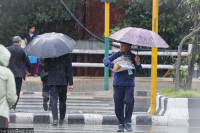
Sun, Jul 26, 2026
Weather
Light rain forecast for western and central Nepal from Friday
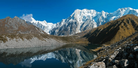
Mountains to retain snow cover. Weather likely to be unfavourable on election day.
bookmark
Post Report
Published at : January 20, 2026
Updated at : January 20, 2026 20:59
Kathmandu
Districts of Sudurpaschim, Karnali, Lumbini, Gandaki, and parts of Bagmati province are most likely to see light rainfall from Friday, as western disturbances originating in the Mediterranean Sea are affecting the ongoing weather system.
According to the Meteorological Forecasting Division under the Department of Hydrology and Meteorology, the rainfall will bring some relief from dust pollution.
“We are still monitoring the situation and will issue a statement on weather developments,” said David Dhakal, a meteorologist at the division. “Light rainfall will occur in the western parts of Kathmandu from Friday.”
The department had earlier forecast a hot and dry winter (from December 1 to February 28), with both maximum and minimum temperatures expected to remain above average. No rainfall has occurred since the start of the winter season, and this has caused a dry spell across most parts of the country and worsened air pollution.
For the past several days, day temperatures have also been rising. The air quality in several parts of the Kathmandu Valley has reached very unhealthy levels every day, worsening respiratory problems.
Nepal is one of the world’s most vulnerable countries to the climate crisis and has witnessed extreme weather events in the past decade and a half.
Evidence indicates that the maximum temperature in Nepal is rising at a greater rate (0.05 degrees Celsius per year) than the minimum temperature (0.03 degrees Celsius per year).
Experts say the impact of the dry spell will intensify in the coming days, as a strong weather system has yet to develop over the Mediterranean and Arabian Seas. However, they said that the mountains will not turn black this year, as sufficient snowfall occurred during the post-monsoon season and the snow is still present. Two weather systems—a cyclone in the Bay of Bengal and a low-pressure area in the Arabian Sea—caused medium to heavy rainfall in the last week of October.
The met department also said that weather conditions in mountainous regions, including Humla, Dolpa, Manang, and Mustang, will not be favourable on election day, March 5.
“Mountainous parts in the western region will again witness snowfall from Friday,” said Madan Sigdel, associate professor at the Central Department of Hydrology and Meteorology under the Tribhuvan University. “But half of the country will remain dry, and the effects of the prolonged dry spell will start to emerge in the coming days.”
Despite the prolonged dry spell, its effects have not been widely felt, as post-monsoon rains and snowfall have provided sufficient moisture. Experts say if no new weather system develops in the Arabian Sea and the Mediterranean Sea, the dry spell will be prolonged until the premonsoon season, exacerbating forest fire incidents, worsening air quality, and causing adverse impacts on agriculture and animal husbandry, as well as increasing water woes.
Nepal has been experiencing a hot, dry winter for the past four years. Experts say extreme weather events—excess rainfall in short periods, continuous rains for several days after the monsoon, dry spells, droughts, below-average precipitation, and above-normal winter temperatures—have become more frequent in recent years.
Despite the early onset of the monsoon last year, many places, especially the plains of the Tarai, which is also the food basket of the country, witnessed mid-monsoon droughts, which prevented farmers from cultivating their land. The government had declared Madhesh a crisis zone.
Numerous studies over the past decade and, more recently, the IPCC report, have warned that since Nepal is one of the most vulnerable countries to the climate crisis, business-as-usual approach will not be sufficient to tackle the impacts of the disasters.


Editor's Picks
Proposed ‘Romeo and Juliet’ law may spare boys, but what about girls?

Three prime ministers, 10 premierships. Why is Sudurpaschim still Nepal’s poorest province?

Inside the strange, disciplined, unreachable world of Nepal’s Prime Minister

Three credit booms in three decades ended in economic downturn

How Nepal could lose a generation of footballers due to FIFA’s suspension
E-PAPER | July 26, 2026
×