 25.91°C Kathmandu
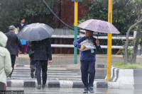
Mon, Jul 27, 2026
Weather
Hill and mountain regions to receive moderate rain Tuesday
Met office issues yellow warning, meaning people need to stay alert to changing weather conditions.
bookmark
Post Report
Published at : March 30, 2026
Updated at : March 30, 2026 17:45
Kathmandu
Most places in the hilly and mountainous regions will witness moderate rainfall on Tuesday, as three weather systems—the western low-pressure system, a local system, and east-south winds—have become active simultaneously.
The Meteorological Forecasting Division under the Department of Hydrology and Meteorology has issued a yellow warning, which means people need to stay updated on weather developments.
“Most places in the hilly and mountainous region, including the districts of Kathmandu Valley, will witness moderate rainfall on Tuesday,” said Min Kumar Aryal, a senior meteorologist at the division. “The ongoing weather system that has been causing rainfall for the last several days will start improving from Wednesday.”
According to the weather bulletin issued by the division on Monday, a yellow warning has been issued for 56 districts. A yellow warning signifies that serious consequences are possible, though the likelihood is low. Bad weather conditions could still disrupt daily life.
No warning has been issued for 21 districts in the Tarai region bordering India.
Aryal said that some places in the Tarai region could also witness light to moderate rainfall with thunder on Tuesday. On Monday, some places in the Bagmati province, including districts of the Kathmandu Valley, and parts of Koshi and Gandaki provinces, will witness light to moderate rainfall.
The division classifies moderate rainfall as 10 to 50 mm, heavy as 50 to 100 mm, very heavy as 100 to 200 mm, and extremely heavy as 200 to 300 mm.
Since the start of the pre-monsoon season, most parts of the country have witnessed strong winds, thunder, hail, and lightning, coupled with moderate rain. Some districts, including Jhapa, Chitwan, and Gorkha, among others, witnessed heavy rainfall, triggering floods and landslides.
With premonsoon activities becoming more pronounced, Nepal’s air quality, which had remained toxic for the past several months, has improved significantly in recent days. Rainfall also brings relief to farmers, as rice and maize cultivation has started.
This year, incidents of forest fire have not increased compared to previous years, thanks to pre-monsoon rainfall.
“Drought conditions have not yet started, but we can anticipate severe forest fires in the coming days," said Aryal. “April and May is peak forest fire season. Those residing near forests or who have to go to forests should be cautious about the risks.”
Meanwhile, the National Disaster Risk Reduction and Management Authority said that five districts witnessed thunderstorms on Monday and three people were injured. Two districts witnessed landslides in which one person was injured, and one person was killed by a flood. On Sunday, nine people were injured when lightning struck them. As many as 11 people who were stuck in the flooding were rescued.
Since the start of the Nepali year 2082 (or mid-April last year), 416 incidents of thunder strikes were recorded in which 47 people died, and 307 were injured.
Nepal is one of the world’s most vulnerable countries to the climate crisis and has witnessed extreme weather events over the past decade and a half. The weather has turned more unusual and destructive in the past couple of years.
Evidence suggests that the maximum temperature in Nepal is rising at a faster rate (0.056 degrees Celsius per year) than the global average of 0.03 degrees Celsius per year.
Experts say extreme weather events—excessive rainfall in a short period, continuous rains for several days after the monsoon, dry spells, droughts, below-average precipitation, and above-normal winter temperatures—have become more frequent in recent years.


Editor's Picks

Proposed ‘Romeo and Juliet’ law may spare boys, but what about girls?

Three prime ministers, 10 premierships. Why is Sudurpaschim still Nepal’s poorest province?

Inside the strange, disciplined, unreachable world of Nepal’s Prime Minister

Three credit booms in three decades ended in economic downturn

How Nepal could lose a generation of footballers due to FIFA’s suspension
E-PAPER | July 27, 2026
×