Overexploited for years, the Chure hills are weakening, and water stress is rising across the Tarai
Groundwater that once lay at 20 to 25 feet is now sinking beyond 110 feet in several parts of the Tarai. The Chure is geologically fragile, composed of loosely consolidated sedimentary rocks that erode easily. Post file photo
The fragile Chure range, long recognised as the principal recharge zone for groundwater in the Tarai, is steadily losing its ecological function, pushing vast stretches of fertile plains towards an unprecedented water crisis.
A recent study shows that increasing soil erosion, landslides and excessive extraction of riverbed materials such as sand and gravel in the Chure have sharply raised the risk of declining groundwater levels. According to a 2023 research brief published by the President Chure-Tarai Madhesh Conservation Development Committee, the weak geological structure of the Chure, compounded by intense human activity, has significantly reduced the land’s natural ability to absorb and store water. This has intensified water scarcity in areas south of the Chure-Bhawar belt.
Erratic rainfall patterns have further worsened the situation. Reduced precipitation, combined with short bursts of intense rain that fail to percolate into the ground, along with rapid settlement expansion along the foothills, have disrupted natural water storage systems.
Last year, cities such as Birgunj and Janakpur faced acute drinking water shortages even in June, as borewells failed to recharge despite the onset of the monsoon season. Following a prolonged drought, the government led by then prime minister KP Sharma Oli declared Madhesh province a disaster-hit zone on July 23 last year.
In the Tarai-Madhesh region, most households rely on hand pumps (shallow tube wells) for drinking water. With traditional wells falling into disuse and tube wells drying up, communities are increasingly facing severe water shortages. Premnath Paudel, a geologist with the President Chure-Tarai Madhesh Conservation Development Committee, said falling groundwater levels have already rendered many shallow pumps ineffective. “Last year, many Tarai districts faced an acute shortage of water. For water to reach the plains, the Chure must recharge. But recharge has declined, and the situation is likely to deteriorate further,” said Paudel.
The Nepali part of the Chure, also known as the Siwalik hills, stretches approximately 800 kilometres from Ilam in the east to Kanchanpur in the west, covering parts of 37 districts and accounting for 12.78 percent of Nepal’s total land area. In the Lumbini province, it extends from Bardaghat of Nawalparasi to the Chisapani bridge in Bardiya, with a north-south width ranging from 10 to 50 kilometres.
Geologist Paudel said failure to conserve the Chure’s complex terrain—comprising low hills, plains, valleys and the Bhawar (the area between Chure and the Tarai)zone—has accelerated environmental degradation. Expansion of roads and urban areas, along with unregulated extraction activities, has worsened water shortages year after year.
The roots of the crisis date back decades. Following malaria eradication in the 1960s, resettlement programmes opened the Tarai for habitation, marking the beginning of large-scale environmental degradation in the Chure. Subsequent construction of the East-West Highway led to further deforestation, while the rapid spread of crusher plants and uncontrolled use of heavy machinery intensified damage. Widespread drilling of boreholes for irrigation and drinking water has also pushed groundwater levels deeper.
Environmental expert Bijay Singh Danuwar said these cumulative factors have dried up natural water sources. “Resettlement, deforestation during highway construction, and unregulated industrial activity have all contributed to the decline of water sources,” he asserted.
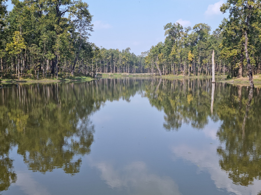
Wetland in Chitwan. Photo: Courtesy of Mahesh Dhakal
According to the President Chure-Tarai Madhesh Conservation Development Committee, indiscriminate limestone mining has further increased erosion in the Chure hills. Meanwhile, expanding urban settlements with concrete structures and paved roads prevent water from infiltrating the ground, instead directing it into rivers. This reduces soil moisture and groundwater recharge. “This has created a dual crisis. Water is not being replenished underground, while surface runoff is increasing floods and landslides,” said Danuwar.
Local residents have witnessed dramatic changes. In the past, groundwater could be accessed at depths of 20 to 25 feet. Now, in many areas, it has fallen to more than 110 feet. Arjun Upadhyaya of ward 6 of Tilottama Municipality in Rupandehi said the water table has been dropping by 10 to 15 feet annually. “Earlier, we could get water at 30 feet. Now we need to drill up to 70 feet or more,” he said. “The Tarai is being pushed towards desertification.”
Namraj Bhattarai, a senior hydrogeologist at the Groundwater Resources and Irrigation Development Division Office in Dang, said degradation of the Chure and fragmentation of agricultural land have severely affected groundwater recharge. “Until a decade ago, water flowing from the Chure spread across large tracts of land and seeped underground over weeks. Now forests are gone, and flat land has been covered with concrete. Water flows directly into drains and rivers,” he said. He added that districts such as Rupandehi, Kapilvastu and Dang are already facing serious challenges in sustaining agriculture.
The Chure is geologically fragile, composed of loosely consolidated sedimentary rocks that erode easily. Environmental researcher Yubaraj Kandel warned that ignoring this sensitivity could lead to serious disasters. “Afforestation is essential to stabilise slopes and prevent soil erosion. Without immediate action, the consequences could be severe,” he warned.
Conservation efforts are currently under way in the Chure region spanning nine districts of Lumbini province, covering the jurisdiction of 52 local units. However, exploitation of the Chure, rapid settlement expansion and infrastructure development have disrupted its natural groundwater recharge system.
“The Chure hills are becoming increasingly barren due to unchecked extraction. Green cover has disappeared, and urbanisation and infrastructure expansion have prevented water from being absorbed within the Chure itself,” said Ananath Baral, chief of the Programme Implementation Unit under the President Chure-Tarai Madhesh Conservation Development Committee in Butwal. “This has had a direct impact on the adjoining fertile plains of the Tarai, where groundwater levels are now declining.”
Rising siltation, vanishing rivers
Rivers and streams that once flowed perennially along the East-West Highway have now been reduced to mounds of sand and gravel, reflecting a deepening environmental crisis in the Tarai.
From Saptari to Bara in Madhesh Province, there are around a hundred rivers and rivulets. Until a decade ago, many of them maintained a steady flow throughout the year. Now, several have run completely dry. Rivers such as Dudhaura, Pasaha and Bakaiya in Bara, along with Dhansar, Chadi and Paurai in Rautahat, no longer carry water except during heavy rainfall. Similarly, rivers like Kamala in Dhanusha and Ghurmi and Bataha in Siraha have begun to dry up over the past decade.
Locals say these rivers once never ran dry. Their sources—springs and seepage from the Chure hills—have now disappeared. At present, not a single drop of water can be seen in many of them unless there is heavy rainfall in the upper Chure region. Areas that once held water throughout the year have turned barren.
Durga Waiba of Piluwa in Bara recalled that water used to flow continuously near the Dudhaura bridge, attracting wildlife in large numbers. “Now that the springs in the Chure have dried up, the river no longer has water. A decade ago, it flowed all year round. Now there is nothing but sand,” he said.
Experts attribute this change to a combination of human activities. Encroachment and unplanned settlements have led to widespread deforestation, reducing the land’s ability to absorb water. Excessive and unregulated extraction of sand, gravel and stones has caused riverbeds to sink and natural springs to become buried. Conservationists say construction activities, tree felling and destruction of water sources in the Chure have all contributed to the drying up of rivers.
Shaligram Upadhyaya of Rautahat criticised the lack of effective state intervention. “We are now seeing rivers that once never ran dry turn barren,” he said. “The primary reason is the mindless extraction of the Chure. Running bulldozers there is like strangling the Tarai.”
The consequences are being felt most acutely in agriculture, the backbone of the Tarai’s economy. Butu Mahato, a 70-year-old farmer from ward 1 of Brindaban Municipality in Rautahat, said water shortages have left fields uncultivated. “We could not plant paddy on time last year due to lack of water. Rainfall was unreliable, and bore wells failed because the groundwater had dried up. As a result, production declined,” he lamented. Mahato, who owns two bigha (1.35 hectares) of land, said nearly four kattha (0.14 hectares) remained fallow. He added that delayed planting reduced yields significantly.
The ecological impact has also been severe. Aquatic life and riverbank ecosystems are deteriorating rapidly. Despite this, the government continues to allocate substantial funds for Chure conservation.
The President Chure Conservation Programme, launched in the fiscal year 2009-10 under the initiative of Nepal’s first president, Ram Baran Yadav, is a national pride project aimed at preventing desertification in the Tarai. According to Sharadbabu Pageni, an information officer at the committee, millions of rupees have been allocated annually for conservation efforts in Madhesh province. However, activists argue that the results remain largely invisible.
Division Forest Officer Hemant Sah in Rautahat linked the crisis to broader environmental degradation, noting that Chure destruction has triggered floods, shifting river courses, declining agricultural productivity and falling groundwater levels.
Vanishing springs, mounting woes
As water sources in the Chure hills begin to dry up, wildlife is facing an acute shortage of water. From February to May, scarcity has become routine. Hydrogeologist Paudel said that although the crisis appears to affect humans most, its impacts on the environment are severe. “We tend to look at it from a human perspective, but both aquatic and terrestrial species are suffering. Springs and ponds have dried up, leaving animals distressed during the dry season,” he said.
To address this, recharge ponds are being built in coordination with local, provincial and federal authorities, said Paudel. Such water bodies help retain moisture, but their disappearance has increased the risk of forest fires in March, April and May. “Ponds maintain humidity, but once they dry, fire incidents rise,” he added.
Karan Bhatta, programme coordinator of a Chure conservation network in Kanchanpur, said springs have been buried or blocked by landslides and erosion. “Rivers and streams are also drying,” he said, stating that the Khanya and Kamikate streams now run dry in winter.
In Jhapa and Ilam, the Chure faces a dual crisis: rampant illegal extraction of riverbed materials and growing human pressure.
According to the President Chure-Terai Madhes Conservation Development Committee, about 20 to 25 percent of Jhapa’s 1,606 square kilometres lies in the Chure. The 2021 census recorded a population of 994,090, many of whom now live in fragile northern belts. Around 39,154 households, or nearly 169,909 people, depend directly on this vulnerable zone, where drying sources continue to threaten livelihoods and ecosystems alike.
Chitwan’s Devital in crisis
Devital, a major wetland inside Chitwan National Park, is facing a growing conservation challenge as sedimentation and invasive plants steadily degrade the lake. Located at the foothills of the Chure range, the lake is increasingly clogged with gravel washed down from the hills, while aggressive aquatic weeds have spread across its surface, reducing visible open water.
According to Hemraj Acharya, conservation officer at the park, sediment from two streams along the eastern and western boundaries has worsened the problem. Of the lake’s roughly 42 hectares, only about five hectares remain visibly open. “Around 17 hectares still hold water, but the surface is covered by invasive plants, making it look like grassland,” he said.
Past clean-up efforts in 2020 and 2021 temporarily improved water levels, but the lake has since deteriorated again. Former chief conservation officer Kamaljung Kunwar said the lake, vital for rhinos and other wildlife, has been gradually silting up despite periodic maintenance over the past two decades.
Officials cite budget constraints as a major hurdle. Chief conservation officer Ganesh Pant said Rs998,000 was spent this year on cleaning, while no funds were allocated last year. Strengthening embankments along feeder streams could help protect the lake, he added.
Chitwan National Park is the main habitat of rare wildlife such as the one-horned rhino, tiger, and many other carnivorous and herbivorous animals, aquatic animals, crocodiles, and birds. Preservation of lakes, ponds, and wetlands is crucial for the survival of these flora and fauna.
 20.91°C Kathmandu


1.jpg)