 20.99°C Kathmandu

Thu, Jul 30, 2026
Culture & Lifestyle
Mapping a nation into being
At Kathmandu Art Gallery, ‘Imaging South Asia: Népal in the Making’ traces how maps shaped Nepal’s political imagination.
bookmark![]()
The maps on display demonstrate that cartography exceeds technical measurement.
Sushan Bhattarai
Published at : March 2, 2026
Updated at : March 2, 2026 07:02
‘Imaging South Asia: Népal in the Making’ at the Kathmandu Art Gallery is a rare exhibition that offers a sweeping account of Nepal’s cartographic historiography from the 18th to the 20th century.
Maps are often defined as a scaled representation of terrain. It reduces distance, converts relief into symbol, and renders spatial relationships legible at a glance. Yet the maps on display at the exhibit demonstrate that cartography exceeds technical measurement. It constitutes a structured way of imagining space, one that evolved over time. Through successive generations of mapping, South Asia, and Nepal in particular, were transformed into a legible and bounded region, with political borders increasingly represented as rigid lines rather than fluid zones shaped by local interaction and exchange.
The history of Nepal’s first modern national map, from 1950, illustrates this dynamic. An account from Satya Mohan Joshi recounts that the initiative emerged from administrative necessity. The newly reorganised state sought to conduct a modern census in line with international statistical standards. Existing territorial categories, such as district, praganna, and tappa lacked standardised spatial definition. In response, officials assembled fragments of a British Indian map discovered in the Munshikhana. Twenty-seven or twenty-eight sheets were pasted together and enlarged using pantographs before being systematically redrawn.
Conducting a census required that territory be conceptualised as continuous, internally ordered, and divisible into discrete administrative units. Villages, rivers, and districts had to be fixed relationally within a unified spatial framework. Dil Bahadur Chitrakar was commissioned to render the map on canvas, inscribing major settlements and outlining district boundaries. When the completed map was displayed in Tripureshwor, viewers encountered a novel spatial visualisation of the nation.
Earlier 19th-century maps reveal a related, though differently situated, cartographic imagination. Produced under the authority of the East India Company and later the Survey of India, they incorporated the Himalaya into an imperial geographic framework. The 1816 Improved Map of India by Aaron Arrowsmith, for example, marked ‘Territories of NEPAUL’ extending from Kangra to the Tista. Major rivers such as the Karnali, Gandaki, and Koshi were delineated with care, and routes from Patna and Darbhanga toward Lhasa were traced across the hills. In these representations, the Himalayan region was not peripheral. It appeared as a connective corridor linking the Gangetic plains with Tibet.
Trade and mobility feature prominently in these maps. Caravan routes from Kathmandu to Kerung and onward to Shigatse were charted with notable precision. Passes, monasteries, and halting points were identified. In certain editions, army movements during the Sino-Nepal conflict were also recorded. The Himalaya thus appears not as an empty barrier but as a terrain structured by circulation.
Commodities such as salt, wool, grain, and textiles traversed these pathways, alongside pilgrims, soldiers, and surveyors. Simultaneously, developments in survey science transformed visual conventions. The 1819 Map of the Province of Kumaon prepared by Captain W J Webb, following the Treaty of Sugauli, employed systematic field measurements. Techniques such as hachuring conveyed relief, while latitude and longitude were carefully plotted. Rivers were labelled repeatedly to ensure clarity. These conventions enhanced empirical accuracy, producing an epistemic claim to objectivity. The Himalaya started to emerge as a measurable mountain chain rather than solely a culturally embedded landscape.
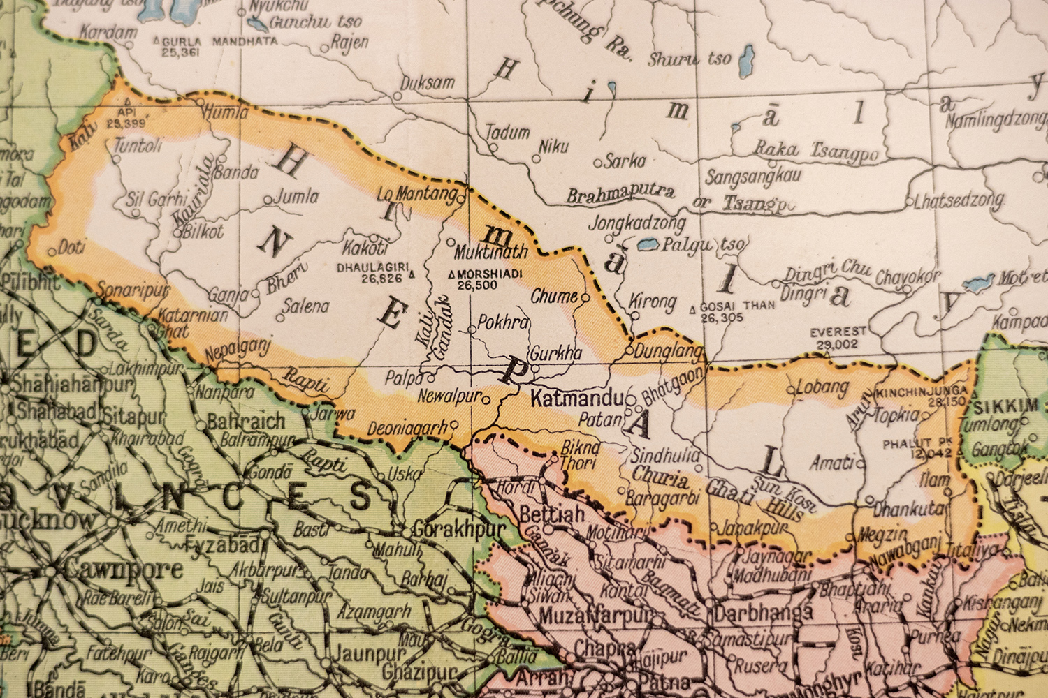
Yet the circulation of spatial knowledge was not unidirectional. The 1856 ‘Preliminary Sketch of Nipal’ incorporated a hand-drawn map transmitted by Jung Bahadur Rana in Devanagari script, which the Surveyor General’s office acknowledged as a source. Local territorial knowledge entered the imperial archive, albeit reframed within British surveying methodologies. By the late 19th century, cartographic revisions further underscore the contingent nature of mapped space.
In the 1879 sheet titled ‘Nepal Tibet & United Provinces’, the naming of certain rivers shifted in comparison to earlier editions. A channel previously labeled Kalee was re-identified, while another tributary assumed the earlier designation.
Taken together, these examples demonstrate that cartographic representation has been central to the production of South Asia as a spatial entity, and that the imagining of Nepal itself evolved across time. The visual grammar of mapping, including colour-coded territories, thick boundary lines, and standardised projections, reinforced the notion of discrete, bounded states. This abstraction contrasts with historical patterns of mobility. Transhumant communities such as the Byansis or Bhote Khampa once moved seasonally across high passes, and trade linked Mustang with Tibet and Gorakhpur with Kathmandu along routes that older maps carefully recorded. In these earlier representations, the Himalaya was understood as a space of circulation, its valleys and passes marked as corridors rather than borders.
Over time, however, cartography transformed. Newer maps increasingly enclosed the same landscape within the lines of the nation-state, erasing much of the mobility that had once defined it. The Himalaya, once a patchwork of seasonal routes and interconnected valleys, came to be imagined as a singular, bounded arc, a frontier dividing states rather than connecting them.
Now, digital technologies such as GPS and GIS have altered methods of data acquisition and visualisation, but not the underlying logic. Satellite imagery and geospatial databases promise unprecedented precision. Nevertheless, decisions regarding scale, projection, classification, and symbology continue to structure interpretation. A boundary line rendered on a digital interface carries the same conceptual force as the coloured demarcations of 19th-century atlases.
The maps in this exhibition thus invite reconsideration of cartography as an epistemic practice. Maps are not passive reflections of territory. They articulate arguments about spatial order. They define centres and margins, stabilise borders, and reconfigure mountains as systems. In the Nepali context, the first national map facilitated administrative consolidation. In the imperial context, survey maps integrated the Himalaya into a broader territorial vision.
In both cases, cartographic practice shaped political imagination. To analyse these materials is therefore to examine the historical construction of South Asia as a bounded and legible space. It was composed through scale, projection, inscription, and line. Through cartographic processes, geography was transformed into geopolitics, and landscapes into state space.
____________________________________
Imaging South Asia: Népal in the Making
Where: Kathmandu Art Gallery, Baber Mahal Revisited, Kathmandu
When: Until March 17
Time: 11:00 am to 5:00 pm
Entry: Free
Sushan Bhattarai
Bhattarai is an early-career researcher working on the history of the Central Himalayas.


Most Read from Culture & Lifestyle


Editor's Picks

Proposed ‘Romeo and Juliet’ law may spare boys, but what about girls?

Three prime ministers, 10 premierships. Why is Sudurpaschim still Nepal’s poorest province?

Inside the strange, disciplined, unreachable world of Nepal’s Prime Minister

Three credit booms in three decades ended in economic downturn

How Nepal could lose a generation of footballers due to FIFA’s suspension
E-PAPER | July 30, 2026
×