Eight of Kalikot’s nine local units face high landslide risk
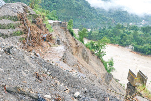
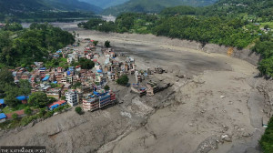
A district disaster assessment identifies most of the district as highly vulnerable, with authorities blaming fragile terrain and poorly built rural roads for worsening the threat. A settlement in Rupsa, ward 5 of Naraharinath Rural Municipality, Kalikot, identified as being at high risk of landslides. Tularam Pandey/TKP
A district disaster preparedness assessment has identified eight of Kalikot’s nine local units as being at high risk of landslides, with only Raskot Municipality classified as facing a moderate risk.
Authorities say the threat is being driven not only by the district’s fragile geology but also by the rapid expansion of poorly engineered rural roads, which have destabilised hillsides and increased the likelihood of slope failures.
Chief District Officer Jhabilal Bhattarai said landslides occur across the district because of its weak geological formation, but unplanned road construction by local units has significantly worsened the risk.
The Karnali Highway and the Karnali Corridor, two of the region’s key transport routes, are repeatedly blocked by landslides whenever heavy rain falls, disrupting travel and the movement of essential supplies.
To improve disaster preparedness, the district has prepared theDistrict Disaster Preparedness and Response Plan 2026, covering a wide range of hazards including floods, landslides, fires, epidemics, drought, lightning, windstorms, falls from cliffs and rockfalls.
The plan, prepared under the leadership of the District Disaster Management Committee, has secured commitments from government agencies, local units and development organisations for its implementation, Bhattarai said.
Assistant chief district officer Janak Sharma said the district has identified landslides, floods, fires, drought, windstorms, hailstorms, epidemics, lightning, falls from cliffs, rockfalls, road accidents and attacks by wild animals as its major disaster risks.
He said authorities have mapped settlements facing the greatest landslide threat and are working through local governments to raise public awareness and strengthen community preparedness.
Kalikot is also highly vulnerable to earthquakes because of its fragile terrain, said Bal Prasad Sanjyal, a member of the District Disaster Management Committee and president of the Kalikot chapter of the Nepal Red Cross Society.
He said strict enforcement of Nepal’s National Building Code is essential for all new construction, arguing that compliance with building standards could significantly reduce casualties and property damage during future disasters.
The district administration, working with the Nepal Police, the Nepali Army and the Armed Police Force, has also expanded search-and-rescue training, emergency information management and disaster response capacity.
The preparedness plan includes stockpiling rescue equipment and strengthening one-door emergency operation centres operated by local units.
Authorities have identified 33 safe evacuation sitesacross all nine local units to facilitate rescue operations during disasters. Potential helicopter landing sites have also been designated to support emergency evacuations and relief operations if roads become impassable.
The district disaster preparedness and response plan has been distributed to the Ministry of Home Affairs, all local units and other relevant agencies.
Deputy Superintendent of Police Him Bahadur Khatri, chief of the District Police Office, said the plan is intended to ensure that available resources can be mobilised quickly and effectively during emergencies.
The District Disaster Management Committee has identified several settlements as among the district’s most landslide-prone areas. These include Rupsa and Malkot in Naraharinath Rural Municipality; Poriban, Palata and Khardu in Sanni Tribeni Rural Municipality; Garuwa and Siyala in Khandachakra Municipality; and Dahachaur and Samalagaun in Shubha Kalika Rural Municipality.
Settlements along the Tila and Karnali rivers, as well as those near the Rahagad, Sannigad, Phugad, Tibgad, Damrigad, Simlagad, Baligad, Padamgad, Takulla, Bali and Khallagad streams, have also been listed as areas vulnerable to flooding and landslides.




 21.05°C Kathmandu