National
Government unveils new political map including Kalapani, Lipulekh and Limpiyadhura inside Nepal borders
The new map has added 335 square kilometres of land in Nepal, taking the total area from 147,181 to 147,516.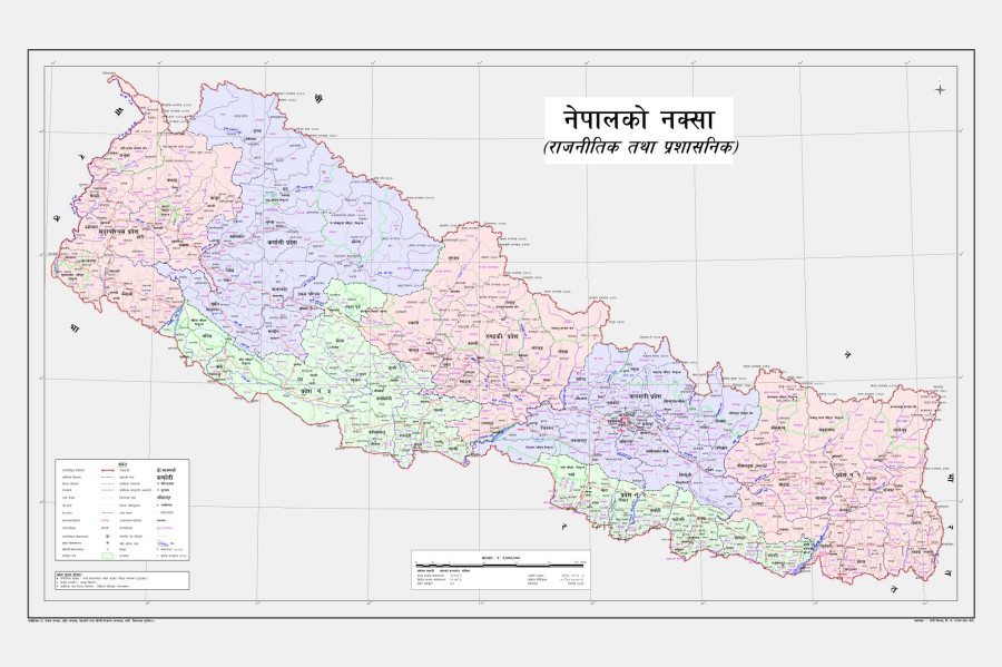
Post Report
Six months after India unveiled its new political map placing Kalapani within its borders, Nepal on Wednesday unveiled its new political map by including the region within its territory.
Padma Kumari Aryal, the minister for Land Management, Cooperatives and Poverty Alleviation, unveiled the map.
The new map showing Kalapani, Limpiyadhura and Lipulekh as Nepali territories was approved by the Cabinet on Monday.
The territories have been shown in Byas Rural Municipality in Darchula district of Sudurpaschim Province.
With adding the disputed land that is currently occupied by India, the total area of Nepal has increased from 147,181 square kilometres to 147,516 square kilometres, according to officials.
“The map will come into use immediately,” said Aryal. “The areas including Gunji, Navi and Kuti near Kalapani, which had been left out in earlier maps, are also included in the new map.”
Minister Aryal said she hoped India will take Nepal’s decision [of publishing a new map] in a positive way.
The government move to publish a new political map was prompted by India’s May 8 announcement that it had opened a road link via Lipulekh to Kailash Mansarovar in the Tibetan Autonomous Region.
As protests erupted, Prime Minister KP Sharama came under pressure from leaders of the ruling and opposition parties to act.
The Oli government, which had sought a date for talks after the Kalpani controversy, on May 9 had issued a statement, objecting to India’s opening of the road via Lipulekh. Delhi swiftly responded, saying the territory belonged to India.
Then again, on May 11, it handed over a diplomatic note to Indian Ambassador Vinay Mohan Kwatra, making its position clear on Lipulekh.
Oli on Tuesday said in his parliament address that the map would be made public by Wednesday. “The decision to include the territories inside the map of Nepal was made after India inaugurated a road link through Nepali territory,” Oli said.
The border dispute in the region, on the northwestern edge of Nepal, has been a perennial irritant in Nepal-India relations.


 18.12°C Kathmandu