 21.67°C Kathmandu
.png&w=200&height=120)
Sun, Jul 26, 2026
Columns
Kathmandu’s man-made flood crisis
It calls for a change in how the city grows, manages water and reconnects with its natural systems.
bookmark
Bishwadeep Paudel
Published at : April 1, 2026
Updated at : April 2, 2026 07:27
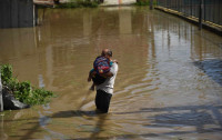
Every monsoon, roads in Teku, Balkhu, Tripureshwor and Anamnagar turn into temporary canals after a short but intense rainfall. Traffic stalls, drains overflow, and residents wander through waterlogged pavements. While heavy rain is often blamed, Kathmandu’s recurring floods are increasingly the result of a series of interconnected problems: Decades of urban expansion, floodplain encroachment and neglected drainage systems. The floods that paralyse the city each monsoon are no longer merely natural events, but rather they are rampantly man-made.
Kathmandu’s geography
Kathmandu lies in a bowl-shaped basin, surrounded by hills. Rain naturally flows down towards the Bagmati, Bishnumati, Hanumante and Dhobikhola Rivers. In the past, the Valley was filled with open fields, ponds and wetlands that allowed rain a place to rest and slowly infiltrate. These spaces acted like cushions, holding water and letting it replenish wells, springs and aquifers. The landscape was naturally shaped to allow water to flow gently and safely, reducing the risk of large floods.
But over the past three decades, Kathmandu Valley has expanded rapidly. The built-up area has increased by nearly four to four-and-a-half times, while population density has risen sharply. These have placed growing pressure on land and existing infrastructure. Agricultural land, wetlands and open spaces have gradually been replaced by dense clusters of buildings, paved roads and commercial complexes.
At the same time, traditional permeable surfaces within the city have declined. Brick-paved courtyards and paths and traditional walkways that once allowed rainwater to seep into the ground have been replaced by concrete and asphalt roads, resulting in excessive runoff. In highly concretised areas, more than half of the rainfall can turn into direct runoff, which is rapidly channelled through drains into rivers. This reduces groundwater recharge and adds tremendous pressure to our rivers, resulting in flash flooding during intense rain showers.
Floodplain encroachment and river constriction
Kathmandu’s rivers once flowed through wide corridors, and their floodplains acted as crucial buffers during heavy rains. Today, much of its protective space has vanished, replaced by residential and commercial settlements. Alarmingly, the city’s own governing authorities have listed portions of these floodplains as residential land, formally demarcating areas along the rivers for construction.
Illegal encroachment has compounded the problem, with informal settlements creeping into the floodplain zone. As a result, rivers that once meandered freely are now confined, and their natural flow is obstructed by unwanted infrastructure. Ultimately, during monsoon rain, water spills into streets and neighbourhoods at a dramatic speed. Thus, Kathmandu’s flood crisis is no longer just a product of heavy rainfall; it is a visible consequence of governance failures, short-sighted planning and decades of wilful ignorance along the city’s most vital natural defence.
Decline of traditional water systems
Kathmandu’s historic network of hitis, canals and ponds once regulated the city’s water flow and recharged groundwater. The network acted as a buffer during monsoon rains. Over time, negligence and rapid urban development have damaged and erased many of these systems, leaving the city more vulnerable to flooding.
Modern drainage struggles to keep pace. Stormwater networks designed decades ago for a smaller city are often blocked or mixed with sewage, overflowing into streets and rivers during heavy rainfall. Residents frequently pave over infiltrating spaces in their homes and directly connect rooftop drains to the municipal drainage system, pushing rainwater into rivers. These practices, combined with the loss of traditional water systems, turn even moderate rainfall into floods that halt traffic, inundate neighbourhoods and expose the limits of the Valley’s infrastructure.
Sustainable solutions
Fixing Kathmandu’s flood crisis requires more than just quick drainage repairs. It calls for a change in how the city grows, manages water and reconnects with its natural systems. One of the most effective steps is to protect and restore the city’s rivers and its floodplains. Green buffers along rivers, strict zoning and preventing further construction in these areas can give the rivers the space they need to carry heavy rain safely.
Rainwater harvesting offers households a simple yet powerful tool. Based on simple hydrological calculation, a moderate rooftop of 100 square metres can capture over 150,000 litres of rain annually. If collected and stored, this water can reduce the amount rushing directly into drains and rivers, slowing floods while recharging groundwater. Lost traditional systems such as hitis, rajkulos, ponds and wetlands should also be revived and connected to modern storage wherever possible. This gives water a place to pause rather than rush through the city.
Blue-green infrastructure such as rain gardens, bio-swales, permeable pavements, green roofs and small urban wetlands can recharge groundwater where concrete currently dominates. These sponge city techniques allow water to seep gradually, reducing pressure on drains and ultimately rivers while creating greener and cooler urban spaces.
Community participation is essential. Residents can audit local drains, manage small ponds, adopt rooftop rainwater harvesting systems and report blockages in drains. Schools, municipalities and local organisations can run workshops to teach these simple yet effective practices.
Combining traditional water wisdom, modern infrastructure and everyday citizen action offers Kathmandu a real chance to tame its floods, recharge its aquifers and reclaim a safer and more sustainable city.Bishwadeep Paudel
Paudel is a civil engineering graduate researching disaster risk reduction and urban water planning.


Most Read from Columns


Editor's Picks
Proposed ‘Romeo and Juliet’ law may spare boys, but what about girls?

Three prime ministers, 10 premierships. Why is Sudurpaschim still Nepal’s poorest province?

Inside the strange, disciplined, unreachable world of Nepal’s Prime Minister

Three credit booms in three decades ended in economic downturn

How Nepal could lose a generation of footballers due to FIFA’s suspension
E-PAPER | July 26, 2026
×