 19.12°C Kathmandu
Sat, Mar 28, 2026
Miscellaneous
GPS way to monitor quake risks
After the Great Earthquake, 24 Global Positioning Systems have been installed along the stretch extending from south of Kathmandu Valley all the way to Churia range to assess the future earthquake risks. The project was a joint initiative of various national and international universities, research institutions and government agencies.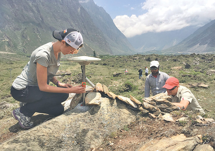
bookmark
Published at : August 21, 2015
Kathmandu
After the Great Earthquake, 24 Global Positioning Systems have been installed along the stretch extending from south of Kathmandu Valley all the way to Churia range to assess the future earthquake risks. The project was a joint initiative of various national and international universities, research institutions and government agencies.
The National Seismological Centre (NSC) had already installed 29 GPS units stretching from Darchula in the west to Taplejung in the east. The data collected from these stations had offered crucial insight into the 7.8-magnitude April 25 earthquake whose epicentre was in Gorkha district.
Bishal Nath Uprety, a geologist at the Tribhuvan University, hopes the data from the newly installed GPS units will offer better
understanding about the nature of earthquakes and their impact zones. The readings from the GPS could also provide the information like which areas moved and where the stress is building that could trigger another earthquake, Uprety added.
GPS technology has been widely used since the late 1990s when the magnitude 7.1 Loma Prieta earthquake struck San Francisco. The system includes a constellation of more than 30 satellites orbiting Earth with each satellite broadcasting information about their position and precise time. A GPS receiver is set up for a period of time to make observation ranging between one millisecond to one second. The measurements obtained from the system can track tectonic movements. The same technology was put to use to study the Gorkha earthquake which revealed that a 140 km long faultlines, stretching eastward from Gorkha to Dolakha and moving underneath Kathmandu Valley, had slipped as a result of the tremor.
Geoscientists who are closely monitoring the seismic activities in Nepal after the Gorkha earthquake say it is crucial to study the ground movement and built-up tension along Churia region in the coming days. According to them, the energy that was built-up in the April earthquake the region south of Kathmandu is likely to be the next seismic risk zone in the future.
Moreover, a latest study published in the journal Nature Geoscience this month mentions that the earthquake released only a fraction of seismic energy of the underlying fault and there still exists the chance of another huge earthquake.


Editor's Picks

Nepal risks losing up to 132,000 jobs, $1 billion after LDC exit

Raped and left to die, teenager’s family wants answers

Bengal tigers move to mid-hills. Sighted in Palpa, Arghakhanchi

Escaping poverty at home, Nepali women fall into the Gulf trap
Once the heartbeat of Nepali democracy, now a ghostly shell
E-PAPER | March 28, 2026
×