 28.38°C Kathmandu
Wed, Jun 24, 2026
Weather
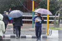
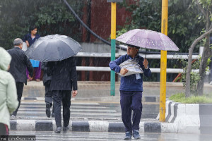
Cyclone Montha’s effects hit Nepal today
High chances of heavy rainfall in Madhesh and Koshi Friday. Improvement expected from Saturday.
bookmark
Arjun Poudel
Published at : October 30, 2025
Updated at : October 30, 2025 07:05
Kathmandu
Nepal is already under cloudy skies, with snowfall in the mountains and light rain in some districts due to a depression in the Arabian Sea. Meteorologists say Cyclone Montha, which originated in the Bay of Bengal and made landfall in India’s Andhra Pradesh on Tuesday night, is set to begin affecting Nepal from Thursday.
Weather is expected to remain cloudy on Thursday morning, with moderate rainfall in the afternoon in Madhesh, Bagmati, Gandaki and Lumbini provinces, met officials say.
They have warned of a high chance of heavy rainfall in Madhesh and Koshi provinces on Friday.
“The entire day will be disturbed on Friday and the chance of heavy rainfall in Madhesh and Koshi provinces is very high,” said Barun Paudel, a senior divisional meteorologist at the Meteorological Forecasting Division of the Department of Hydrology and Meteorology.
“Although Cyclone Montha is gradually weakening, it still carries enough moisture to trigger significant rainfall, when it gains altitude.”
Montha has caused heavy rain in various parts of India. Schools have been shut down, train and road transports affected, and authorities are relocating vulnerable populations to safe zones in the coastal areas, according to media reports.
Paudel added that high mountainous areas could witness heavy rainfall on Thursday and Friday. Rain and snowfall triggered on Monday by the Arabian Sea low-pressure system are expected to subside by Wednesday night in most places. However, districts of Karnali Province could witness light rainfall due to the same system.
Met experts have warned that the heavy rainfall seen in the first week of October is likely to repeat starting Thursday, with Koshi and Madhesh provinces expected to be hit the hardest.
They have advised commuters, trekkers and those planning mountaineering trips to take weather warnings seriously. Farmers have been urged to postpone crop harvest until Saturday.
With the peak rice harvesting season underway, farmers in most places across the country are busy collecting crops. Many farmers have already been affected by rain since Monday evening.
The met office, in its special bulletin issued on Tuesday evening, warned that water flow in Bagmati, Koshi, Kamala, and Kankai rivers, and their tributaries, could increase significantly and reach alert thresholds. Likewise, there is a chance of sudden rises in small rivers that run through the Mahabharat and Chure ranges in Koshi, Bagmati and Madhesh provinces.
There is also a high chance of sudden increases in water levels of small rivers in Kathmandu Valley, Kavrepalanchok, Sindhupalchok, Dolakha, Makawanpur, Chitwan and Sindhuli of Bagmati province; Bara, Parsa, Sarlahi, Rautahat, Mahottari, Dhanusha, and Saptari of Madhesh province; and Sankhuwasabha, Taplejung, Panchthar, Terhathum, Bhojpur, Dhankuta, Ilam, Jhapa, Morang and Sunsari of the Koshi province.
Nepal is one of the world’s most vulnerable countries to the climate crisis and has witnessed extreme weather events over the past decade and a half. The weather has turned more unusual and destructive in the past couple of years.
Evidence suggests that the maximum temperature in Nepal is rising at a faster rate (0.056 degrees Celsius per year) than the global average of 0.03 degrees Celsius per year.
Experts say extreme weather events—excessive rainfall in a short period, continuous rains for several days after the monsoon, dry spells, droughts, below-average precipitation, and above-normal winter temperatures—have become more frequent in recent years.
Arjun Poudel
Arjun Poudel is a health reporter for The Kathmandu Post. Before joining the Post, he worked for Sagarmatha Television, Naya Patrika, Republica and The Himalayan Times.


Most Read from Weather
Editor's Picks

Inside the mission of Everest’s first mountain rangers
Weak arbitration defence costs government billions

Nepalis making treacherous trip to Europe through the Balkan route

Women are often at the centre of Nepali films. Why are men still telling most of their stories?
What old newspapers reveal about Kathmandu’s World Cup fever in the 80s and 90s
E-PAPER | June 24, 2026
×