 23.04°C Kathmandu


Sun, Jul 26, 2026
National
Eviction drive exposes decades of settlement expansion on public land
From highway towns to market centres, settlements built on public and forest land across Nepal face growing uncertainty as authorities intensify anti-encroachment campaigns.
bookmark![]()
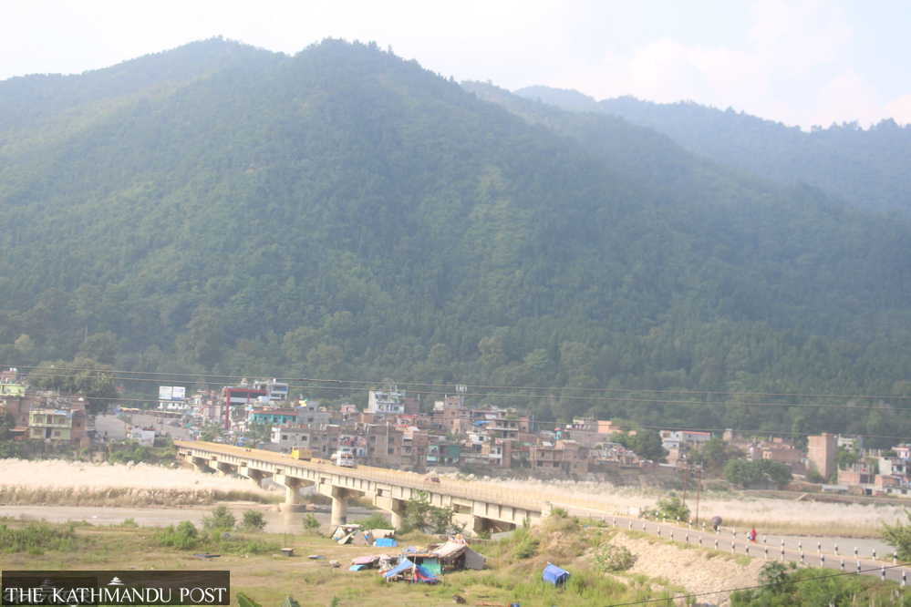
Bhalubang bazaar in Ward 1 of Rapti Rural Municipality, Dang, the capital of Lumbini Province. Durga Lal KC/TKP ![]()
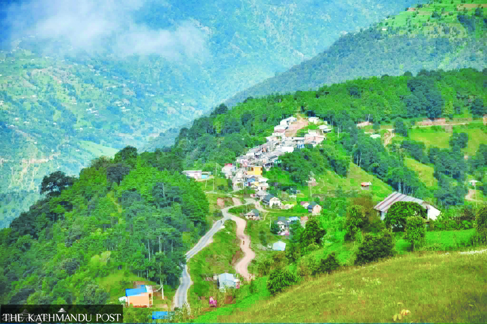
Dandabas bazaar in Thaha Municipality, Makwanpur district, built on public land. Post file photo
Kamal Panthi, Madhav Aryal, Pratap Bista & Ghana Shyam Gautam
Published at : May 7, 2026
Updated at : May 7, 2026 14:49
Bardiya/palpa/hetauda/butwal
As authorities intensify demolition of squatter settlements and structures built on public land, the eviction drive has expanded across Nepal.
Under directives from the federal government, local authorities across the country have begun issuing notices ordering residents to vacate squatter settlements, encroached public land and illegally occupied areas.
In Kathmandu and several major towns, bulldozers operating under tight security have already demolished settlements and structures built on public land.
Following federal directives, local governments, industrial corridors, protected areas and district forest offices have continued issuing public notices ordering residents to clear occupied land.
Yet many of Nepal’s major urban centres themselves have developed on ailani and parti land, Nepali terms used for unregistered or uncultivated public land, over decades, exposing the scale of unmanaged urbanisation and the challenge now facing authorities.
Large settlements along the East-West Highway have been built on public land. Although local governments are legally responsible for protecting such land, settlements have steadily expanded over the years.
As authorities now attempt to reclaim public land, long-settled residents are increasingly protesting against possible eviction.
Most residents of Deukhuri in Dang, the capital of Lumbini Province, still do not possess land ownership certificates.
Spread across 31 bigha (one bigha equals 0.25 hectares), 7 kattha and 13 dhur, nearly 1,300 houses in Bhalubang in Rapti Rural Municipality fall within the national forest and Chure areas.
Settlement in the area began around 1970, according to Jagat Pokharel, former president of the Rapti Chamber of Commerce and Industry in Bhalubang.
“There are now at least 450 businesses operating in Bhalubang market, but nobody has land ownership certificates,” he said.
In the northern Kapilvastu district too, most settlements stand on government land.
Three major urban areas in Rupandehi district have also developed on unregistered land. Large sections north of the Mahendra Highway in Devdaha Municipality, the Tinau riverbank area in Butwal and much of Murgiya in Sainamaina Municipality are located on public land.
Large private homes and commercial buildings now stand on land officially owned by the government. Despite the absence of ownership documents, land and houses are routinely bought and sold for millions of rupees, depriving the state of potential revenue.
At the same time, local governments have extended electricity, drinking water, telephone connections and other public services to these settlements.
Roads have been blacktopped with investments worth millions of rupees. In the three major urban areas of Rupandehi alone, an estimated 2,000 to 2,500 new houses are added every year. Local governments continue collecting revenue through building permits and map approvals.
Dense settlements in Devdaha Municipality, including Khaireni, Charange, Bhawanipur, Sheetalnagar, Madangram, Keuli, Sarantari and Satakkhola, all stand on government land.
Settlements north of the highway have expanded across public land and the Chure region. Around 40 percent of Devdaha’s 136 square kilometres consists of forest and Chure areas.
Encroachment along riverbanks, forests and Chure foothills continues even now. Forest encroachment and settlement expansion in the area began in 1982 under a forest strengthening programme.
Siddhicharan Bhattarai, who researches forest areas and unmanaged settlements in Devdaha, said the northern highway belt is increasingly being occupied by unmanaged settlers.
“There is no alternative except proper management,” he said. “The government must regulate settlements while protecting unregistered land.”
Sainamaina Municipality has also expanded along the Chure foothills. More than 45 percent of settlements there stand on public land and Chure foothills. Settlement in Sainamaina began around 62 years ago.
Population density in the Murgiya market area under wards 3 and 4 increased sharply after 1983. Every year, between 600 and 700 new houses are reportedly built on unregistered land.
Market areas including Murgiya, Parroha, Jharbaira, Dudharaksha, Sorauli, Kalauni and Saljhandi all stand on public land.
Around 45 percent of households in Sainamaina’s market area still do not possess land ownership certificates, according to Ram Bali Chaudhary, a former elected representative from the Panchayat era through the multiparty period.
On Chaudhary’s initiative, then King Birendra Shah supported the construction of government structures centred around Murgiya in 1983. Development in Murgiya and the surrounding areas accelerated after that.
“About 100 bigha of unregistered land has been developed into settlements,” he said. “Now encroachment has expanded into the Chure foothills.”
He said the government may eventually be forced to distribute ownership certificates even if forest areas have to be reduced.
A large settlement has also emerged on reclaimed land along the Tinau riverbank in Butwal-11.
Locals refer to the area as a “sukumbasi city”, using the Nepali term for landless settlers. Dense settlements, including Devinagar, Buddhanagar, Majuwa and Sundarnagar stand along the Tinau corridor, while the state has provided all basic services there. The municipality approves building plans and collects revenue, but residents still do not possess land ownership certificates.
Large buildings and infrastructure have been constructed there under the category of landless settlements.
“Many people living on public land in Tinau own rental houses elsewhere, educate their children and send them abroad,” a resident of Butwal-11 said.
Locals say political parties previously encouraged settlement expansion there to build vote banks, making it difficult to remove encroachers from the Tinau area.
Most public and Chure land in Rupandehi has been encroached upon under categories such as displaced settlements, landless settlements, Block Number 8, forest land and reclaimed riverbank land.
According to Kumar Thapa, chairperson of the Rupandehi Land Issue Resolution Commission, authorities have identified 76,646 landless and unmanaged settler households across the district.
These households have been categorised as landless Dalits, landless squatters and unmanaged settlers.
“There are a large number of unmanaged settlers,” Thapa said. “They have been living on government land and reclaimed riverbank land.”
He said local governments across the district have already completed the first phase of data collection.
According to commission records, Rupandehi has 2,997 landless Dalit households, 6,658 landless squatter households and 66,400 unmanaged settler households.
Butwal Sub-metropolitan City alone has 333 landless Dalit households, 943 landless squatter households and 15,598 unmanaged settler households. Sainamaina has 325 landless Dalit households, 404 landless squatter households and more than 15,400 unmanaged settler households. Devdaha has 160 landless Dalit households, 265 landless squatter households and 13,605 unmanaged settler households.
In Palpa district, towns have expanded onto public land in Rampur Municipality, Kaseni of Mathagadhi Rural Municipality, Damkada of Tansen Municipality, Phek of Ribdikot and Prabhas in Tansen.
Land ownership certificates were distributed in Bejhad, Rampur’s main market area, only last year, even though 854 families had lived there for decades without ownership documents. Of them, 702 families received ownership certificates for the plots they occupied.
Since around 1978 and 1979, schools and the former Rampur Village Development Committee had distributed residential plots there through political consensus. Residents subsequently occupied and used the land.
Political leaders and senior government officials had lobbied to transfer land registered in schools’ names into private ownership. Houses had already been constructed on unregistered land before ownership certificates were eventually distributed.
Kaseni Sarai in Mathagadhi Rural Municipality-3 is another unmanaged settlement area. Divyajyoti Secondary School distributed nearby plots in exchange for support for school operations.
Landholders have applied to the Land Issue Resolution Commission seeking ownership certificates as unmanaged settlers. Land transactions in the area are conducted using receipts.
Fifty-two landless settler households are currently living in Panityanki, about one kilometre south of Tansen Tudikhel. More than 400 people are affected by disputes involving guthi land.
Public land has also been encroached upon in Prabhas, a historic and religious area. Local officials say land mafias have increasingly targeted the area over the past 15 years.
Despite this, local authorities failed to protect the land. People have built houses using various receipts and supporting documents. Land Revenue Office officials say nearly 70 ropani of government land in the Prabhas area has gradually disappeared.
Encroachment accelerated after the establishment of Lumbini Medical College and Teaching Hospital nearby.
In around 1993, Gyanmala Secondary School in Phek, Ribdikot Rural Municipality-8, sold 24 plots of public land as residential plots.
School authorities defended the move, saying the school lacked funds to operate grade 8 classes. According to them, the school at the time could not raise Rs50,000 and sold plots measuring 20 hands in frontage for Rs2,000 each.
Concrete houses have since been built there and the area has developed into a market centre.
According to official records, Palpa district has 7,670 households categorised as unmanaged settlers, landless Dalits and landless squatters.
Rampur Municipality has 1,218 unmanaged settler households, 65 landless Dalit households and 71 other squatter households. Tansen Municipality has 1,227 unmanaged settler households, 174 landless Dalit households and 325 other squatter households.
Purwakhola has 26 unmanaged settler households. Mathagadhi has 663 unmanaged settler households and seven other squatter households. Tinau has 1,613 unmanaged settler households, 45 landless Dalit households and 245 other squatter households.
Rainadevi Chhahara has 1,063 unmanaged settler households, six landless Dalit households and 24 others. Baganaskali has 102 unmanaged settler households, 10 Dalit households and 15 others. Ribdikot has 62 unmanaged settler households, 10 Dalit households and 15 others.
Rambha has 27 unmanaged settler households, four Dalit households and six others. Nisdi has applications from 680 unmanaged settler households, seven Dalit households and 15 others.
Authorities said processes have moved forward for 5,932 applicants whose documents are complete.
In Makwanpur district, residents of two settlements in Thaha Municipality say they are increasingly worried about losing their homes due to the eviction drive.
Residents have lived for 50 years in Simbhanjyang and Daman in ward 4, and in Dadabas market in ward 7.
Settlement in Simbhanjyang and Daman began during the construction of the Tribhuvan Highway. Residents who have lived there for more than five decades still do not possess land ownership certificates.
“We have lived here since our grandfathers’ time,” said Lal Bahadur Bhujel of Simbhanjyang. “The government repeatedly promised to conduct land surveys and distribute ownership certificates, but it still has not done so.”
Bhujel said residents now live in fear because the state and land commissions failed to distribute ownership certificates.
“We developed Simbhanjyang and Daman. We did not encroach on them,” he said.
There are around 100 households in Simbhanjyang and Daman.
Dadabas in Ward 7 of Thaha Municipality has also developed into a tourist destination. Located 10 kilometres from Shikharkot market, Dadabas once served as the old market centre of the former Agra Village Development Committee.
The market has remained active for five decades. A blacktopped road runs through the settlement. Dadabas is now an organised market despite residents lacking ownership certificates. More than 100 concrete houses stand there.
“If settlements are removed in the name of anti-encroachment, around 50,000 houses in Makwanpur would need to be demolished,” said Bishnu Bista, mayor of Thaha Municipality.
He said residents of Chepang and Bankariya settlements, as well as most residents in Bakaiya and Bagmati rural municipalities, still lack ownership certificates because the state failed to distribute them in time.
During the Maoist insurgency in 2004, Shreeram Chaudhary moved with his family from Satti in Kailali district to the Krishnasar area in Gulariya-2 of Bardiya district. He has lived there in a temporary shelter ever since.
Similarly, the family of Sukha Lal Tharu moved there from the former Kachanapur area. Lautan Tharu of Gulariya-1 has also been living in the Krishnasar area since 2005.
According to Bhoj Raj Pant, chief of the Krishnasar Conservation Committee in Khairapur, the area now contains 142 households.
“About 79 bigha, 1 kattha and 1 dhur of land in this area has been encroached upon,” he said.
In 1996, the government paid compensation and relocated settlements from 245 bigha of land there, but some families continued living inside the conservation area.
Ninety-three households accepted compensation, but many did not leave. After 2006, more people from districts including Jumla and Kalikot also settled there.
Residents now fear eviction.
“We will be left helpless if the government removes us because we do not own land,” said local resident Sabitri Tharu.
Deependra Yadav, chairperson of the Krishnasar Conservation Area Committee, said many people left ancestral homes under relatives’ care and built temporary shelters inside the protected area.
He said the government should identify and properly manage genuine landless settlers.
On April 27, Division Forest Office chief Bijaya Raj Subedi issued a 15-day notice ordering residents to vacate encroached areas.
He said authorities would first clear encroachment in Kothiyaghat, Machad and Orali market areas before expanding the campaign elsewhere. A total of 88 houses — 27 in Kothiyaghat, 42 in Machad and 19 in Orali — are set to be removed.
According to official records, 63 community forests under the office have been encroached upon. Earlier records had identified encroachment in 258 community forests.
Although official records show encroachment of 290.98 hectares of forest land, forest officials say the actual figure is far higher.
Subedi said at least 1,000 hectares of forest land may currently be under encroachment.
What is ailani land?
Ailani land refers to public land without registered ownership. Such land exists extensively across Nepal.
According to Gyan Nath Dhakal, chief of the Butwal Land Revenue Office, the term generally refers to riverbanks, forests, roadsides, lakes, ponds, cliffs and surrounding areas classified as public or barren land.
“Ailani land refers to land without private ownership rights but under state protection,” he said. “In many cases, even the government itself does not possess ownership certificates or proper records for such land.”
Assistant Chief District Officer Meghnath Upadhyaya of Rupandehi said authorities are currently compiling records of public land and squatter settlements with support from local governments and state agencies.
“We are collecting details of public and barren land,” he said. “Conservation work will begin after the study is completed.”
Under the Land Revenue Act 1977, public land includes roads, pavements, railways, government buildings and offices. The law also classifies forests, rivers, streams, reclaimed riverbanks, lakes, ponds, canals, cliffs and barren land as public land.
Madhav Aryal
Madhav Aryal is the Palpa correspondent for Kantipur Publications.
Pratap Bista
Pratap Bista is the Bagmati Province Bureau Chief for Kantipur Publications.


Most Read from National

Chinese envoy voices concerns over upcoming Tibetan studies seminar in Kathmandu
Twenty-one Pulchowk graduates join Airbus this year
PM Shah to break self-imposed rule with separate meetings with Indian, Chinese envoys

Kathmandu steps up Susta security, Delhi seeks details

Ambassadorial selection in final stretch
Editor's Picks

Proposed ‘Romeo and Juliet’ law may spare boys, but what about girls?

Three prime ministers, 10 premierships. Why is Sudurpaschim still Nepal’s poorest province?

Inside the strange, disciplined, unreachable world of Nepal’s Prime Minister

Three credit booms in three decades ended in economic downturn

How Nepal could lose a generation of footballers due to FIFA’s suspension
E-PAPER | July 26, 2026
×