Nepal sent its disaster alert 38 minutes after the glacier collapse. It wasn’t enough
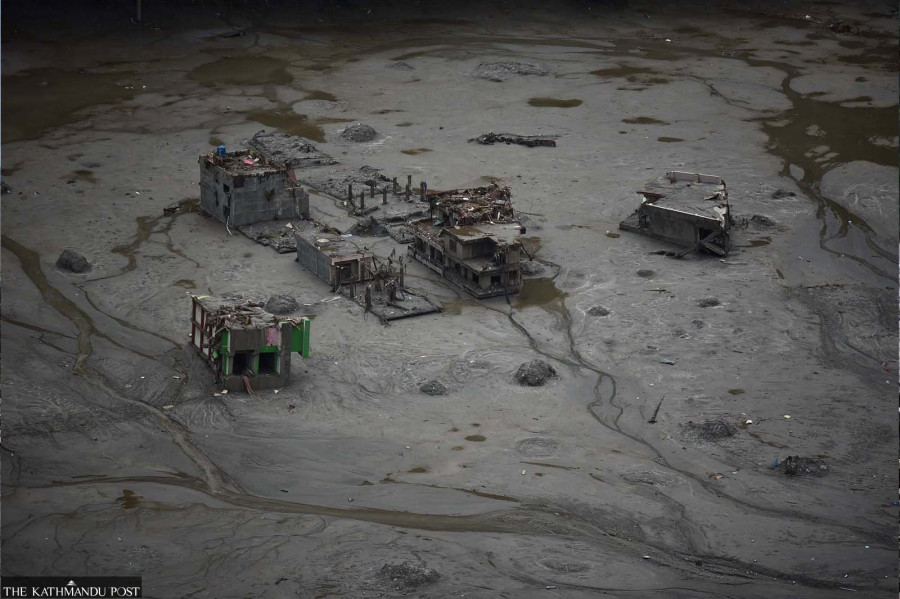
Some Nepalis survived the Bhotekoshi and Rasuwa flood by luck, not by warning. Their story, and interviews with the officials who built Nepal’s flood alert system, exposes their limits and shows how a knowable risk went unmonitored for years. An aerial view reveals severely damaged and collapsed structures submerged in thick, grey mud following a catastrophic flash flood in Bhotekoshi river. The heavy mudflows swept through the area, leaving buildings partially buried and destroying local infrastructure. Post Photo
Nima Dorje Tamang was in Hakubesi, a hamlet south of Syafrubesi in Rasuwa, when the flood struck. Before Tamang could prepare, he heard a thunderous roar and saw the flood gushing toward him, its waves taller than him.
Tamang and his family ran uphill for their lives but the waves caught him and a rock struck his leg, fracturing it. Swept into the river, he managed to grab a tree near the bank and clung to it for what felt like two hours until his father and his brother came to rescue him. For the next 24 hours, he said he slipped in and out of consciousness before a helicopter brought him to Kathmandu.
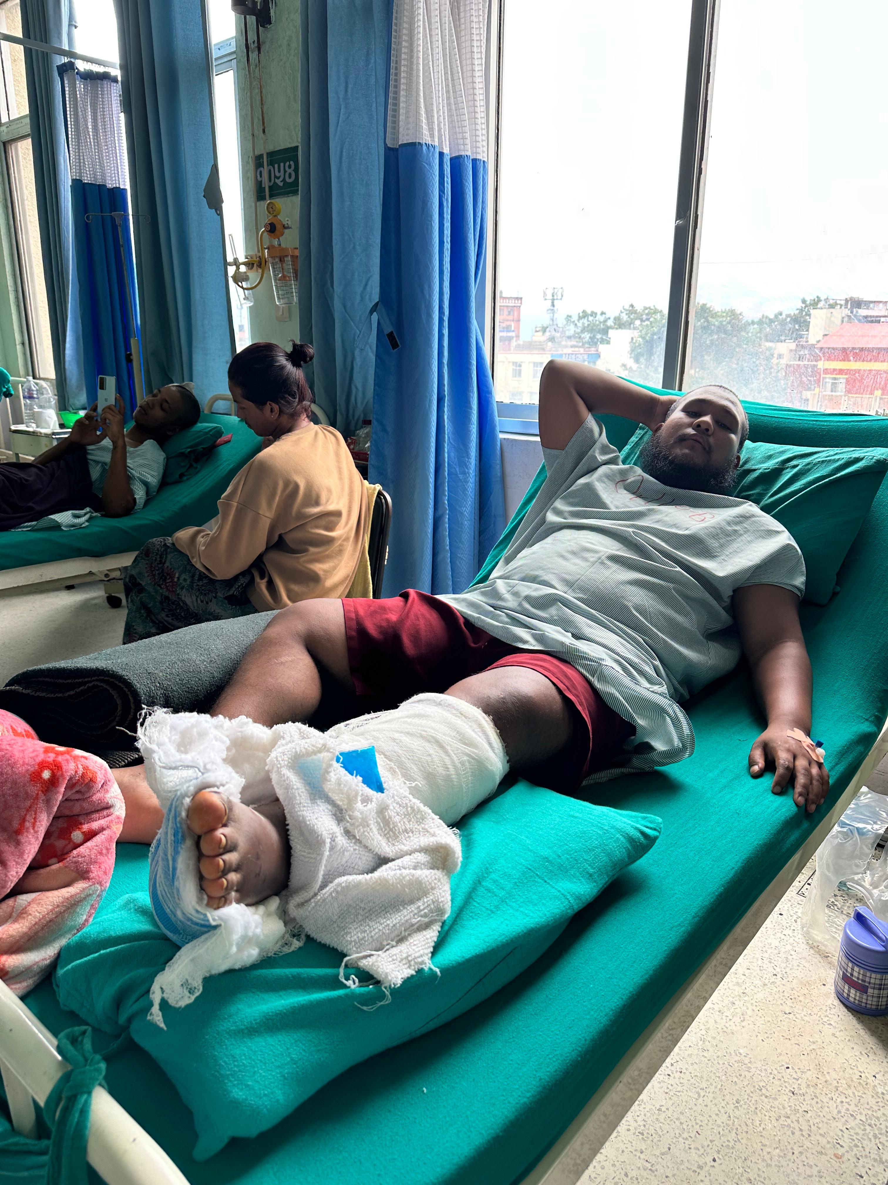
At the orthopedic inpatient ward of Tribhuvan University Teaching Hospital, Tamang told the doctors, “Even the air makes it hurt,” when they pressed his left foot. It was still swollen after the surgery. But from his hospital bed, Tamang worried about his family back home. “We lost our uncle, aunt, sister, and brother-in-law,” he said. “And everyone says there will be a massive flood again.”
Like Tamang, communities and authorities were caught off guard when the glacier collapsed at 8:37 AM on August 26. Scientists say the likelihood of predicting this particular type of disaster was minimal, and the resulting flash flood surged so rapidly through the steep mountain terrain that there was little time to warn communities downstream. But the disaster exposed a deeper problem: Nepal’s warning systems remain largely designed around individual hazards, while disasters in the Hindu Kush Himalaya are becoming increasingly complex, cascading and transboundary. “There is no such thing as an early warning system in Nepal. Simply having sensors does not mean it’s a system; it has to be much more comprehensive,” said Anil Pokhrel, former chief executive of National Disaster Risk Reduction & Management Authority (NDRRMA), stressing the word “system.” For it to be a system, it needed to have a proper assessment of who and what is at risk, he said, then an observation system to anticipate hazards in real time, a comprehensive communications plan for timely alerts, and preparedness for emergencies.
“If the Chinese sensors detect something upstream, a series of sirens should automatically go off all at once. Text messages should go off with a loud buzzer even if it is on silent mode,” he added.
Over the last decade, Pokhrel said Nepal had invested a lot on the observation side, installing sensors. Without multiple sets of sensors monitoring different hazards across different locations, as we saw with Rasuwa floods, it is inadequate to save lives.
When the massive glacial collapse hit the Lhende valley, near the Nepal-Tibet border, Nepal’s Department of Mines and Geology recorded seismic activity. “Our records showed a 4.4 magnitude. But the frequency of the seismic activity did not match that of an earthquake, which is the department’s monitoring mandate, so we did not alert the public like we usually do,” said Lok Vijay Adhikari, chief of National Earthquake Monitoring and Research Center in the Department of Mines and Geology. The US Geological Survey also initially recorded the event at magnitude 4.4, but later revised its assessment, attributing the seismic activity to the glacial collapse.
In the minutes that followed, rising water levels in Bhotekoshi in Rasuwa could potentially have provided another opportunity to alert the public. It was the same Lhende Khola, a transboundary high-altitude river that originates in Gyirong County in Tibet and flows toward the Nepal border, feeding into Bhotekoshi as well as Trishuli downstream. But at 8:50 AM, the flash flood swept away the gauge in the Bhotekoshi river in Rasuwa, at the Syabrubesi hydrological station. Designed to detect gradual rises in the rivers, the gauges were ill-equipped to detect the high-speed flood.
Who knows what to do with the warnings
Twenty-three minutes later, the District Administrative Officer in Rasuwa informed the Department of Hydrology and Meteorology (DHM) about the flash flood. “We informed DHM at nine. We could not do much in Rasuwa because the flood had destroyed the [communications] towers, yet local authorities informed communities, and people went from door to door warning each other,” said Shanti Mahat, spokesperson of NDRRMA.
“But for people downstream we used every means to inform them—through text alerts, caller tune, media broadcasts, and police miking,” she added.
Within 15 minutes of receiving the information, at 9:15 AM — 38 minutes after the ice-rock avalanche — people in Rasuwa, Nuwakot, Dhading, and Chitwan got text alerts that advised them to immediately move to safe, higher ground as water levels in the Bhotekoshi river in Rasuwa had crossed the danger threshold. It also listed hotlines for rescue assistance.
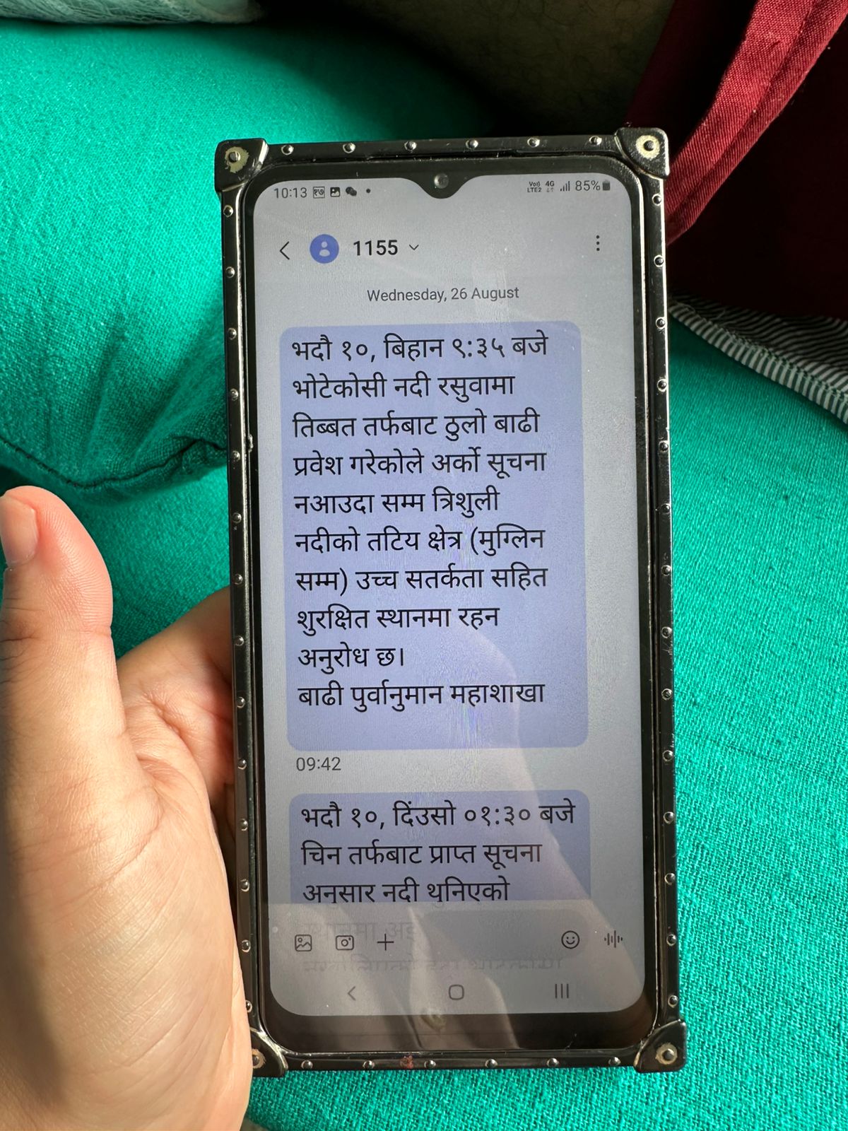
Nima Dorje Tamang’s mobile phone showing the warning text message he received.
Such alerts are critical in a crisis. Over 95 percent of Nepali adults have mobile phones with data, and it is an effective method even if language and literacy levels may hinder access.
Early warning mechanisms can also be basic, where people are vigilant, spot a danger, inform on time, and those at risk know how to act.
Himanshu Thakkar, coordinator of the South Asia Network on Dams, Rivers & People recalled an incident from the 2021 glacier collapse in Chamoli of Uttarakhand in India, part of the Hindu Kush Himalayan region. “A woman who was on top of a hill saw the flood [in Rishi Ganga] ravaging from a distance and immediately informed her husband, who was working at the hydropower project downstream,” Thakkar said. Her husband initially did not believe her because he could not see the flood. When he finally caught sight of it, he alerted his colleagues, and a group of them ran uphill and survived.
He juxtaposed that with having information about a risk and not knowing how to act on it, referring to the tour guide Ziha Yitie and other mountaineers in Tibet who videographed the slab of glacier falling off of Langtang Lirung Peak. But they did not immediately understand what they were seeing and realized the magnitude of the disaster only after descending down.
Where does accountability lie?
Ultimately, the responsibility for timely warning lies with the state. Nepal already has a bilateral flood-forecasting mechanism with India where the two countries exchange rainfall and river level data. But Nepal is mainly the provider of information, as most of the monitoring stations are in Nepal’s upstream rivers. On the other hand, despite agreements between the two presidents—Xi Jinping and Bidya Devi Bhandari—in 2019, committing to promote cooperation in different fields, including addressing climate change and protecting the environment, seven years on, the countries still do not have even a rudimentary early warning plan.
“There is no protocol. The practice that we have right now is that we cooperate with the Ministry of Foreign Affairs to share information,” said Prakash Pokhrel, Geologist at NDRRMA. “Whenever a foreign country is involved, we have to go through the ministry.”
The danger of not having a mandatory protocol, former NDRRMA chief executive Anil Pokhrel warned, is that, “It comes down to the subjective judgement of individuals in authority who may or may not choose to inform.”
After last year’s catastrophic supraglacial flood in the same Bhotekoshi river in Rasuwa, Nepal’s monitoring of that area remained limited. The northern side of Nepal’s mountain range, however, happened to be in a “blind spot” that no one, including Nepal, China, and international geologists, was monitoring.
Asked if the area was a low priority for Nepal, government officials suggested it was easier said than done.
“The terrain above the settlement in Timure is extremely remote and difficult to access,” said Mahat. “While we have monitoring stations at the Bhotekoshi river, setting up stations that provide real-time data farther out has been very challenging. Even now we’re struggling to get images using drones.”
Dinkar Kayastha, information officer at the DHM, says that looking at the resources at their disposal, it is impossible to monitor everything, especially when 20 to 25 percent of Nepal is mountains.
Pointing to the Thame flood of 2024 in the Everest region, Kayastha said, “We saw that even such small glacier lakes, that were not considered threatening, can become devastating.”
As of now, according to him, Nepal has monitored major “high-risk” glacial lakes including Imja Tsho in the Khumbu, Everest region, and Tsho Rolpa in Rolwaling valley of Dolakha.
After last year’s flood in Bhotekoshi, Pokhrel, the geologist at NDRRMA, said they were monitoring potentially dangerous glacial lakes every day using satellite images to identify the risk of glacial lake outburst floods. International Centre for Integrated Mountain Development (ICIMOD) has identified 21 potentially dangerous glacier lakes in Nepal across Gandaki, Koshi, and Karnali river basins and mapped 2070 lakes. Their numbers and their size are not absolute; ICIMOD’s research found that as temperatures rise, both the number and size of the lakes are increasing in Nepal.
Earlier this year in March 2026, ICIMOD also warned that glaciers in the Hindu Kush Himalaya were melting at double the rate since 2000. They warned that catastrophic floods and water uncertainty were testament to the fact that it was a critical decade for the cryosphere, where retreats in certain parts could be irreversible. Yet, out of the 38 glaciers ICIMOD monitored, only seven met the global benchmark, and many in the region remained largely unmonitored.
But Prakash Pokhrel said the same satellite images are far less useful for anticipating a glacier collapse. “Many places look stable. We can’t know from the images how fractures have developed or if weathering has occurred,” he said.
The Asian Development Bank, the Asian Infrastructure Investment Bank, and International Finance Corporation were among the major financiers of the Upper Trishuli-1 hydropower project, while China’s state-owned Exim Bank funded the Upper Trishuli 3A project. The projects also included financing from British International Investment, Korea Development Bank, and Exim Bank of Korea, as well as the Netherlands FMO, OPEC Fund and Canadian Climate Fund.
The Asian Development Bank’s panel of independent experts overseeing the Upper Trishuli-1 project had recommended strengthening the warning system and emergency plan, coordinating alerts with hydropower projects upstream and downstream, and putting evacuation protocols in place for dangerous floods.
Nima Dorje Tamang receiving treatment at Tribhuvan University Teaching Hospital.
“But they don’t do it. It’s complete callousness. There is no accountability in South Asian countries,” said Thakkar. “They [funders] know nobody is going to be held accountable so they just get away with it.”
Thakkar said that hydropower projects can aggravate disaster risks by creating additional vulnerabilities in already fragile Himalayan landscapes through deforestation, tunnelling, blasting, excavation and muck dumping. Dams can also worsen downstream flooding, while reservoirs accumulate silt that can create additional risks. When multiple hydropower projects are built in a cascade, he said, these impacts accumulate and multiply.
Climate change is adding another layer of risk through more intense rainfall, warmer winters, melting glaciers and thawing permafrost.
“Our dishonest EIAs, lack of accountability in governance and non-implementation of basic monitoring, forecasting and implementable disaster management plans is worsening the disaster impacts in river valleys with multiple hydropower projects,” said Thakkar. “By not doing independent post-disaster impact assessments, we have shut the doors for learning any lessons for the future.”
Nepal’s Trishuli river basin alone, which originates in Rasuwa, has 36 hydropower projects in various stages of construction and planning. In Tamang’s village in Hakubesi, he said about eighty percent of the population worked at the Upper Trishuli-1 hydropower plant, and the rest of them were children or the elderly.
“We have no choice but to go to Kathmandu or to the Dhunche [headquarters of Rasuwa] for work. But with the hydropower people stayed back. Now all of them are trapped in it, the hydropower is gone, we have nothing,” he said. The government’s latest data shows 639 people remained trapped in Upper Trishuli-1 and Trishuli 3A.
What next?
For Dr. Saswata Sanyal, who is a disaster risk reduction specialist at ICIMOD, people need to understand the changing realities of living in the Hindu Kush region, where the risks we were familiar with yesterday are no longer the same today.
The Rasuwa flood was a testament to the complex interactions of hazards. “Something triggered an ice avalanche that led to flash floods, debris, sediments and boulders,” he said. Relief efforts since the disaster have also been affected by monsoon rains and flood alerts.
“The risks can be further exacerbated by earthquakes or climate change, so we need to understand the complex nature of hazards in the mountains,” he added.
Flood sensors, even if some of them were washed away in the flash floods in the Trishuli river in Galchchi, continued to be critical in monitoring the drastic increase in water levels and warning people. Sanyal suggested that it’s imperative for Nepal to increase those sensors upstream, not just in its own territory, but other countries in the Hindu Kush region should collaborate to do the same.
Pokhrel, the former chief executive of NDRRMA, added that Nepal needs to set up multiple sensors in diverse locations. Even for floods, he suggested, it’s not enough to install sensors in the bridges, and recommended setting them up on top of hills that can detect seismic waves or the rumble of boulders and floods to alert people using sirens.
Sanyal says people need to comprehend the scale of the Hindu Kush region.
“It has around 54,000 glaciers and more than 2000 glacier lakes, and permafrost covering an even larger area,” he said. While it is not possible to track every inch of the region, he suggested prioritizing the monitoring of areas with settlements downstream, with the countries not only sharing data but also working closely with each other.
Similarly, to identify risks in remote mountain areas that are difficult for scientists and government officials to routinely access, Anoop Nautiyal, climate advocate based in Dehradun, Uttarakhand, recommended training local communities on basic glaciology and hazard monitoring. “They are on the frontline dealing with the climate crisis and need to play a central role in prevention and disaster risk reduction.”
But monitoring cannot stop at national borders when the hazards themselves do not. Many disasters across the Hindu Kush Himalaya are transboundary, making regional cooperation critical. Climate activists, scientists, as well as researchers emphasised the importance of tripartite agreements between Nepal, China, and India, as well as bilateral agreements that go beyond non-bindingcommitments and include mandatory protocols and action plans for timely communication and response. “Every sensor, siren, drill is ultimately to ensure next time more people get a chance to reach safety,” said Sanyal.
Meanwhile, Tamang is worried about his grandparents back at home in Hakubesi. He said they are staying on higher grounds right now, but is concerned that they will soon run out of the limited food they have.
“Rescue, relief, everything reaches very late in our village. I don’t know why. There are still 100 to 200 people waiting with no rescue,” he said, showing his mobile phone, which showed that he received the warning text message at 9:42 AM. “I wish they would take them to Dhunche, because I hear there will be another massive flood; perhaps the water won’t reach as high.”




 15.28°C Kathmandu