 20.64°C Kathmandu
.png&w=200&height=120)
Wed, Jul 15, 2026
Columns
When Ilam wept
The intense rainfall earlier this month illustrated how diverse its impacts can be.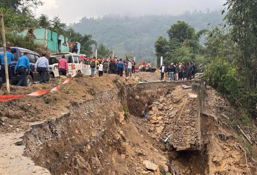
bookmark
Madhukar Upadhya
Published at : October 20, 2025
Updated at : October 20, 2025 07:10
Reeling from last year’s deadly debris flows at Simaltal and Jhyaple khola that killed nearly a hundred people, and heeding the Department of Hydrology and Meteorology (DHM)’s forecast of heavy rain for October 3 through 6 earlier this month, the government took stringent precautionary measures ahead of time. Major highways were shut down, and a two-day public holiday was declared to avert risks to travellers. A prelude to what might happen with heavy rain had already been witnessed near Muglin, where a landslide at Tuin Khola blocked the highway for 45 hours and a subsequent 53 hours within the span of five days (September 19–23), affecting thousands of people travelling home for the Dashain festivities. As predicted, the rain began on the night of October 3 and continued relentlessly into the evening on the 5, dumping over 300 mm of rain in the Tarai and about 200 mm in the Valley.
The government’s prompt decision to close highways, a well-measured step, undoubtedly prevented the substantial loss of lives across the country. However, the stunning and unprecedented devastation in Ilam marked the biggest disaster event the district has seen in recent years. The same rainfall event triggered landslides and debris flow, burying houses and killing 37 people, as well as floods that claimed two more lives.
The rainfall was reportedly so intense that it caused a significant section of the Mechi Highway to collapse and subside. It left cracks in the road; surrounding slopes continued to widen for days, indicating ongoing landslips and slope deformation. The Ilam District Disaster Management Committee (DDMC), in response to the DHM’s forecast, had identified over 20 high-risk locations. However, disturbingly, except for areas around Rajduwali, which suffered particular damage, none of the other rain-battered areas were listed as high-risk. This begs the question: What was lacking in our understanding of the risks in Ilam?
Surging debris flow
Despite the DDMC adopting timely precautionary measures and putting contingency plans in place, the devastation and loss of lives in Ilam were severe because of the widespread debris flow resulting from localised high-intensity rain. This suggests changing rainfall patterns in the mountains. The intense rainfall earlier this month illustrated how diverse these impacts can be. In addition to early warning, several other location-specific measures must be part of the response, especially in the mountains, where orographic elements add to growing complexities.
In recent years, debris flows in the mountains have risen due to localised high-intensity rains, which meteorological stations do not capture. The problem is compounded when micro-channels, conveying runoff along the slopes, are frequently altered by both human and natural factors. Local people generally recognise where risky runoffs are likely to develop and often make diversion channels in and around their houses to mitigate the risk beforehand. Unfortunately, development workers, particularly road builders, predominantly non-locals, do not understand these location-specific realities and unintentionally alter runoff channels during infrastructure development, often without foreseeing the consequences. Local communities are left to face the ensuing loss of lives and property when additional runoff flows through unsafe slopes.
A debris flow survivor in Ilam recalled how debris from the road, resulting from a similar disregard for local understanding of risks, destroyed her property. During road construction above her home some years ago, she urged workers to remove a threatening boulder, but her plea was ignored. On the fatal night of October 4, the boulder rolled down the hill, along with debris from the road, flattening two houses and killing at least four visiting relatives. Such incidents have become pervasive with changing rainfall patterns. In 2018, a similar incident occurred in Jajarkot, where debris from a newly constructed road uphill buried a house and killed eight children inside the home, including the owner.
The year 2020 serves as a baseline to appreciate the increasing severity of debris flow-dominated landslides. That year, more than 400 landslides, several of them quite deadly, killed over 300 people and damaged vital infrastructure across the country. Many were caused by localised high-intensity rain, triggering damaging debris flow in the least expected areas, from Sankhuwasabha in the east to Bajura in the west.
Prolonged heavy rain
Understanding the causes for October’s prolonged heavy rain would help recognise the underlying triggers and the likelihood of similar events occurring, possibly worse in severity, in the future and effectively prepare for the eventuality. The October rain was caused by a cyclonic weather system when the monsoon was retreating. The weather system originated as a cyclonic circulation over the Bay of Bengal, rapidly intensifying into a deep depression primarily driven by elevated sea surface temperatures. Meanwhile, the retreating monsoon had left a residual trough of low pressure over southern Nepal. The interaction between the retreating monsoon and the deep depression was further amplified by orographic lift as it reached the Himalayas, unleashing heavy rains in the central Tarai plains and eastern hill districts. With soils already saturated from delayed monsoon withdrawal, the extreme rainfall resulted in widespread damage.
The rainfall, though not a typical monsoon event, behaved like a monsoon, marked by heavy rainfall, intense convective activity and moisture-laden winds. These traits, driven by warm sea surface temperatures and cyclonic circulation, highlight how post-monsoon systems can extend the wet season’s risks, amplified by climate-driven intensification of rainfall extremes—a lesson for the coming years.
Reaching the vulnerable
Debris flows in hilly regions aren’t anomalies, rather they’re inevitable. They impact rural communities and critical infrastructure like roads, reservoirs, irrigation canals, water intake sites and power plants, vital for both rural and urban populations. Damage to these assets affects a large portion of urban populations, heightening the need for instant mitigation; therefore, the approach often relies in reactive, paramedic-like responses.
The damage assessment, rescue, relief and reconstruction primarily target road corridors. Villages and farms in roadless, remote areas face significant risks, too. Yet, because these areas are mostly unreached, unattended and far from service centres, communities are quite vulnerable to such disasters and consequent neglect. Their capacity to recover and re-establish remains extremely weak. If and when help arrives, it’s often too little, too late.
In sum, addressing debris flow risks requires addressing the cyclical water extremes—monsoon-triggered landslides/debris flow followed by water scarcity—by adopting year-round planning, budgeting, programming and monitoring which prioritise not only urban interests but also other vulnerable populations. Planners must foreground the risks facing people to make disaster responses vastly more effective. Without this, we won’t build the required capacity to address the scale and complexities of this omnipresent hazard in a warmer world.
Madhukar Upadhya
Upadhya is a senior watershed expert.


.PNG&w=200&height=120)
Most Read from Columns
.PNG&w=300&height=200)


Editor's Picks

Proposed ‘Romeo and Juliet’ law may spare boys, but what about girls?

Three prime ministers, 10 premierships. Why is Sudurpaschim still Nepal’s poorest province?

Inside the strange, disciplined, unreachable world of Nepal’s Prime Minister

Three credit booms in three decades ended in economic downturn

How Nepal could lose a generation of footballers due to FIFA’s suspension
E-PAPER | July 15, 2026
×