 20.13°C Kathmandu
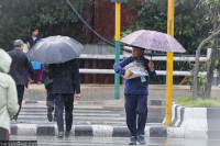
Sun, Jul 26, 2026
Weather
Early monsoon likely this year as rainfall picks up
Meteorologists say there is no chance of heatwave conditions in the Tarai in the next few days.
bookmark
Post Report
Published at : May 19, 2025
Updated at : May 19, 2025 06:32
Kathmandu
As the onset of the monsoon season draws closer, the frequency of rainfall has increased throughout the country.
The Meteorological Forecasting Division under the Department of Hydrology and Meteorology said that most places in Koshi, Madhesh, Bagmati, Gandaki, and Lumbini provinces witnessed light to moderate rainfall on Sunday afternoon.
According to officials, the weather system that caused rainfall in Kathmandu Valley and surrounding districts is now shifting eastwards, bringing an end to rain in places that witnessed afternoon showers. Districts of Koshi Province were expected to witness rainfall later in the day.
However, the system causing rainfall in Gandaki Province is also moving east, which could bring rain to Kathmandu Valley during the night.
“As the monsoon onset date approaches, the frequency of rainfall has increased and will likely continue in the coming days,” said Pratibha Manandhar, a senior meteorologist at the division. “We also do not expect heat wave conditions in Tarai districts for the next few days.”
On Sunday, the Kathmandu valley saw moderate rainfall. The meteorological data shows Kathmandu recorded 30.4 mm of rainfall. The Panipokhari weather station recorded 32.6 mm of rain, Bauddha recorded 21.2 mm, and Panauti of Kavrepalanchok recorded 13.6 mm. Pokhara recorded 50.2 mm rainfall, Biratnagar 23.2 mm, Janakpur 18.4, and Lumle 29.9mm rainfall.
The Indian Meteorological Department had announced the onset of monsoon over some areas of the south Bay of Bengal, the south Andaman Sea, the Nicobar Islands, and some areas of the north Andaman Sea on May 13, one week ahead of the usual schedule.
Nepali meteorologists also anticipate an early start to the monsoon this year.
“Monsoon usually enters Nepal around a week after it begins in Kerala, India,” said Manandhar. “This year, we expect it to arrive earlier than normal.”
Normally, the monsoon reaches Kerala by June 1, and enters Nepal around June 13. It typically lasts until September 23.
In 2025, Nepal is likely to witness above-normal monsoon rains for the second consecutive year, according to a regional consensus among South Asian meteorologists. This has sparked optimism for better crop yields and provided a much-needed lift for the country’s struggling economy.
But the forecast also comes with a warning. Above-normal rains could spell more disasters, including flash floods and landslides.
However, some parts in the north, south, east, and northeast of South Asia may experience normal to below-normal rainfall.
The regional climate outlook was jointly prepared by all nine National Meteorological and Hydrological Services of South Asia, with the assistance of international experts, during the Pune, India session.
Nepal is one of the world’s most vulnerable countries to the climate crisis and has witnessed extreme weather events over the past decade and a half. The weather has turned more unusual and destructive in the past couple of years.
Evidence suggests that the maximum temperature in Nepal is rising at a greater rate (0.056 degrees Celsius per year) than the global average of 0.03 degrees Celsius per year.
Experts say extreme weather events—excess rainfall in a short period, continuous rains for several days after the monsoon, dry spells, droughts, below-average precipitation, and above-normal winter temperatures—have become more frequent in Nepal.


Editor's Picks

Proposed ‘Romeo and Juliet’ law may spare boys, but what about girls?

Three prime ministers, 10 premierships. Why is Sudurpaschim still Nepal’s poorest province?

Inside the strange, disciplined, unreachable world of Nepal’s Prime Minister

Three credit booms in three decades ended in economic downturn

How Nepal could lose a generation of footballers due to FIFA’s suspension
E-PAPER | July 26, 2026
×