Nepal to expand flood warning systems across six river basins
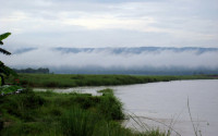
A new white paper outlines plans to lower water levels in four high-risk glacial lakes and strengthen disaster preparedness as climate change intensifies risks in the Himalayas. East Rapti river at Sauraha. Wikimedia Commons
The Hydrology and Water Resources Research Centre has published its 2026-27 white paper, outlining plans to strengthen flood early-warning systems, improve scientific research, and promote sustainable management of Nepal’s water resources.
The centre, established in July under the Ministry of Energy, Water Resources and Irrigation, has outlined priorities for sustainable water use, climate-resilient infrastructure, aviation safety and disaster risk reduction. The white paper emphasises modern technology, open-data systems, and scientific research to protect lives and property.
The centre was formed by bringing together hydrology divisions, sections and functions previously housed within the Department of Hydrology and Meteorology. It operates under the Water and Energy Commission Secretariat and aims to become South Asia’s leading scientific institution by 2031, according to its long-term strategy.
A key priority is the expansion of flood early-warning systems across six major river basins, alongside plans to lower water levels in four high-risk glacial lakes. Rising temperatures in the Himalayas are accelerating glacier melt and increasing the risk of avalanches and glacial lake outburst floods (GLOFs), prompting the government to adopt a technology-driven approach through the centre’s five-year strategic plan and a separate white paper from the Department of Hydrology and Meteorology.
The flood warning systems will be installed in the Mawa-Ratuwa, Bakraha, Lakhandehi, East Rapti, West Rapti and Mohana-Khutiya river basins under the Priority River Basins Flood Risk Management Project. Launched in 2022, the project will run until 2028, with a budget of $7.54 million. The centre’s white paper also notes that the Bagmati Improvement Project is under way.
The government has also prioritised the GLOF Sanjibani Project, which aims to lower water levels in four high-risk glacial lakes: Thulagi in Manang, Lower Barun in Sankhuwasabha, and Lumding Tsho and Hongu-2 in Solukhumbu. The project will run from 2026 to 2033, with a total budget of about $49.9 million, including a $20 million allocation for the centre.
The initiative builds on earlier efforts to reduce the water levels of Tsho Rolpa in the Rolwaling Valley of Dolakha district and Imja Lake in Solukhumbu. The government plans to apply similar risk-reduction measures at the four newly targeted lakes, according to the Ministry of Energy, Water Resources and Irrigation.
To improve technical and administrative services, the centre has opened four regional offices in Dharan, Pokhara, Kohalpur and Attariya. It has also established two field project offices: the Sunkoshi-Bagmati-Kamala Hydrology and Flood Forecasting Project in Sindhuli, and the Upper Karnali Hydrology and Cryosphere Project in Jumla.
The centre has three main technical divisions covering hydrology and cryosphere science, flood forecasting, and water resources research and capacity development. The National Water Resources Laboratory in Godawari is also being upgraded to strengthen its capabilities in hydraulic physical modelling, sediment analysis and testing.
The white paper says the country has established a network of more than 250 monitoring stations to collect real-time hydrological and meteorological data. The network includes 250 river-level monitoring stations, 230 of them automated; 15 glacial-lake monitoring stations; 13 glacier and water monitoring stations; 50 automatic rainfall monitoring stations; and 33 stations each for sediment and water-quality monitoring.




 16.94°C Kathmandu