Nepal, India to finish boundary work in three years, barring Kalapani and Susta
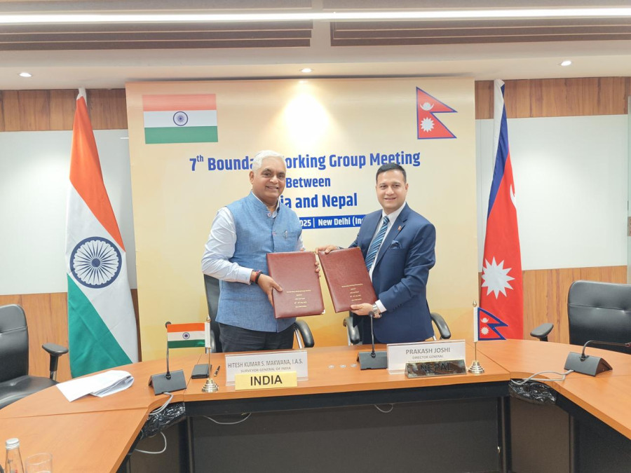
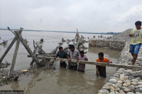
As agreed in the Boundary Working Group meeting in Delhi, joint teams will fix boundary pillars, encroachments, and wrap up work by 2027. Director General of Nepal’s Survey Department Prakash Joshi (right) and his Indian counterpart S Makawana exchange signed minutes at the end of the BWG meeting in Delhi, Tuesday. Photo: courtesy of Mofa Nepal/x
In a major development, senior officials from Nepal and India have agreed to complete the bilateral boundary work within three years and approved the new timeline. The decision was made in New Delhi during the 7th meeting of Nepal-India Boundary Working Group (BWG) on Tuesday. Earlier, the two sides had set two deadlines—in 2015 and 2017—but officials could not meet them.
“We have decided to complete the technical tasks of the Nepal-India border, besides Susta and Kalapani, within three years,” Prakash Joshi, director general at the Department of Survey, told the Post. “As per the mandate given to the BWG, we set a new deadline and decided to resume the field work as soon as possible.”
Joshi led the Nepali delegation in the meeting, which included senior officials from the ministries of foreign affairs, defense, and home, and security agencies, among others.
In 2015, the two sides had set a deadline of three years and later, in 2017, they had set a renewed deadline of 2022 to complete the boundary work at technical levels.
But both deadlines were missed due to various reasons including lack of funds, the Covid pandemic, erratic boundary disputes, and climatic conditions, among others.
Due to Covid and boundary dispute between Nepal and India, even the meeting of BWG was pushed back for six years after 2019.
In order to prepare the timeline and roadmap to conclude the boundary works, the two sides have agreed to convene the 12th meeting of Survey Officials’ Committee (SOC) in Nepal in August.
To meet the three-year timeline, both sides have agreed to resume the joint fieldwork immediately.
Within three years, survey officials from Nepal and India will construct the new boundary pillars and repair the damaged ones. Likewise, according to Joshi, both sides will prepare the inventory of encroachments carried out by both sides in ‘no–man’s land’ and will prepare the inventory of cross holdings of properties by citizens of both sides.
There are documented cases of Nepali nationals cultivating land on the Indian side and Indian nationals occupying and cultivating land within Nepali territory. These cross holdings of properties need to be documented so that higher authorities could resolve the issue later.
Besides these, in the meeting, the two sides have agreed to upgrade and update the global positioning system (GPS) base station.
Nepal and India are using an internationally accepted positioning system—Nepal-India Boundary Global Navigation Satellite System (NIB GNSS)—while mapping the Nepal-India boundary pillars.
The latest map between Nepal and India, besides Susta and Kalapani, was prepared on the basis of GPS which was agreed in 2007. Based on these 182 sheets of maps, the BWG is constructing the new pillars in place of missing ones, repairing boundary pillars, clearing the no-man’s land, and preparing the inventory of cross holdings of properties, among others.
In the last six years, after the BWG meeting was not able to meet, both sides had entrusted the Armed Police Force (APF) and Sashastra Seema Bal (SSB) to carry out the field survey, maintenance of the damaged pillars and some other small technical works. So the upcoming Survey Officials’ Committee (SOC) meeting will seek support from APF and SSB to prepare the timeline, said Joshi. “We have decided to provide some concrete results within this year, and in that spirit, we will resume the technical work on the boundary,” Joshi added.
Besides BWG and SOC, there is another bilateral mechanism, called Joint Field Survey Teams (FSTs).
All three teams had the task of constructing, restoring and repairing boundary pillars, clearing the no-man’s land, GPS mapping of boundary pillars, collecting data of property holdings across the border and resolving any other boundary dispute.
Data from Nepal’s Department of Survey shows that 8,554 boundary pillars have been installed along the border. Of these, 1,325 are missing and 1,956 are either partially or fully damaged.
Under the BWG, two supporting mechanisms—the Survey Officials’ Committee and Joint Field Survey Teams—provide technical inputs and are mobilised on the ground.
“The meeting was held in a very conducive atmosphere and the Indian side was very positive towards resuming the technical works,” Joshi told the Post. “It has been six years that we have not met. Now we have decided to resume the field work and after taking the report from APF and SSB, we will hold the meeting of SOC in Nepal.”
Joshi had led the Nepali delegation and the Indian delegation was led by Shri Hitesh Kumar S Makwana, the surveyor general of India.
The meeting reviewed the implementation of the outcomes of the 6th BWG Meeting held in August 2019 in Dehradun as well as the progress of works from the 11th Survey Officials’ Committee (SOC) Meeting held in September 2019 in Dehradun, said the Ministry of Foreign Affairs.
“The meeting adopted updated modalities for the inspection, repair and maintenance of boundary pillars along the Nepal and India Boundary and agreed on the need to adopt new technologies in the domain of survey and mapping in order to make the work of the BWG and its associated mechanisms more efficient,” the foreign ministry said in a statement on Tuesday.
The meeting concluded with the signing of agreed minutes.
Both sides agreed to hold the next meeting of the Survey Officials’ Committee (SOC) in Nepal next month and the next meeting of the BWG in Nepal at a mutually convenient date, said the foreign ministry.
The BWG is a joint body constituted by the governments of Nepal and India in 2014 to carry out work in constructing, restorating and repairing boundary pillars and other technical tasks.
Both sides reviewed the progress of work done subsequent to the last (6th) BWG meeting held in August 2019, said a statement issued by Survey of India. The two sides jointly adopted “Updated Modalities for Inspection, Repair and Maintenance of Boundary Pillars along the India-Nepal Boundary” and agreed to expedite work in this regard.
The BWG meeting also finalised the work plan for the next three years, the Indian statement added.
Finally, it was agreed that the next Survey Officials Committee (SOC) meeting would be held soon in Nepal on mutually agreed dates, said the Indian statement further.
Nepal and India share a 1,880 km long border spanning over 27 districts. Before the Covid pandemic, boundary work in Jhapa, Sunsari, Kailali and Parsa districts was completed.
Primarily, the BWG meeting has to prepare a blueprint to complete the remaining boundary work, data of properties held by citizens on either side of the border, installing and repairing 8,554 boundary pillars, installing GPS facilities and resolving the boundary dispute where the river changed the course. Some boundary pillars were renovated and repaired jointly by the APF and SSB whose data will be forwarded to the SOC in August and there will be new data that needs to be erected and need to be repaired and maintained.
“Most property holdings problems on both sides are due to changes in river courses,” another Nepali participant said. “The major issue is collecting complete data on citizens’ property holdings on both sides of the border.”
Due to the changes in the courses of hundreds of rivers, thousands of hectares of land have shifted to either side of the border, and this data is being collected by the SOC and FSTs.
Anil Giri is a Chief Sub Editor covering diplomacy, international relations and national politics for The Kathmandu Post. Giri has been working as a journalist for more than two decades, contributing to numerous national and international media outlets.
 22.75°C Kathmandu