Sudurpaschim Province
Floods, landslides plague people living on banks of Budhiganga
Local residents living in disaster-risk zones have been requesting relocation to safer areas but authorities are yet to come forward with a plan.
Arjun Shah & Basant Pratap Singh
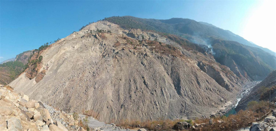
A massive landslide occurred in Paima, Bajura, nine years ago. Around the same time, another landslide struck Amkot.
Around 14 hectares of land has been swept away by landslides and floods in the last decade and both the settlements, home to more than 300 families, are still at high risk.
The Budhiganga flows between Paima of Tribeni Municipality and Amkot of Badimalika Rural Municipality. Land in the two villages has developed cracks due to recurring landslides, and the river gets flooded every monsoon as landslides dam its flow.
Local residents of the two villages are still coming to terms with disasters of the past that have threatened to displace the population time and again.
Netraraj Padhya, a priest in Paima, said landslides carry mud, boulders, and other debris into the river blocking its natural flow. “Last year a section of the river was blocked by a landslide. Three months later, the dam burst and the current swept away roads and bridges downstream,” said Padhya.
Last year, floodwaters from the river entered settlements in Bajura and wreaked havoc.
Jadanga, Taprisera, Sera Bagar and Barjugad in Bajura are prone to landslides every year. Similarly, Budha Bagar, Thanti Bazaar, Sanfebagar and Baidyanath—settlements in downstream Achham—are also at the risk of disasters. Budhi Ganga Hydropower Project is also at risk of being affected.
“The airport and settlement in Sanfebagar and Kalimati settlement in Baidhyanath will be completely washed away if precautions are not taken right away,” said Kul Bahadur Kunwar, mayor of Sanfebagar Municipality.
The Budhiganga joins the Seti at Lode, which falls on the district’s border with Achham. The river then flows through several settlements of Achham, Kailali and Surkhet before joining the Karnali.
The mid-hill region of the Karnali province is fragile and prone to landslides, say experts. According to Deepak Rijal, a specialist in Disaster Risk Management, floods in Budhiganga have a domino effect on the ecosystem of the region. “Budhiganga gets blocked every year by landslides. If this continues, the lives and properties of those living in settlements near the riverbanks will be at peril.”
He suggests conducting a geological study to identify the risk in those areas. “On the basis of the study, a disaster preparedness and management system can be formed and permanent flood control strategies can be adopted,” he said.
During last year’s monsoon, around a five kilometre section of the tarmacked Sanfe-Maratdi road section was swept away by floods and landslides in Taprisera-Amkot area in Bajura. Likewise, a Bailey bridge over Budhiganga and a suspension bridge over Taprisera were also swept away.
Over 40 houses were swept away by landslides. Since then, many settlements are at risk of floods and landslides. Many families have also lost their fertile fields to rapid flooding.
A team led by Home Minister Ram Bahadur Thapa, Chief Minister of Sudurpaschim Province Trilochan Bhatta and others had also inspected the flood and landslide-affected area following the disasters.
But their visit did not bear any fruits, say local residents. Prakash Shah, a resident of Sanfebagar, said, “Authorities talk about the destruction caused by floods and landslides only after disasters occur. They never come up with prevention strategies.”
Anil Pokhrel, chief executive officer with National Disaster Risk Reduction and Management Authority (NDRRMA), the central authority overseeing disasters incidents and minimising risks, said the disaster-struck area faces multiple challenges.
“As the area sees massive landslides every year and debris has been falling into the river for several years, addressing an imminent disaster is not an easy task. The mudslide into the river has continued for several years and the situation is turning into a potential disaster,” Pokhrel told the Post. “The immediate implications will be on road networks in the area. The Department of Roads has been looking at several options to minimise damages.”
For a long time now, local residents of Bajedi in Ward No. 2 of Budhiganga Municipality have been demanding relocation to a safer place. Every monsoon, residents of 126 households take shelter in local forests or the Bajedi Basic School due to threats of landslides.
Janga Nepali, a local resident of Bajedi, said, “During the last monsoon, we leave our houses for a month in view of the landslide threat. We have been demanding relocation for the last two and a half decades.
“Authorities do not pay attention to our plight unless people get killed,” Rangalal Jaishi, another local of Bajedi, told the Post. “We have asked the ward officials to relocate our settlement to a safer place, but nobody listens to our pain.”
Gumlagaun in Khaptad Chhededaha Rural Municipality is also affected by the Guigad landslide. “Forty-seven families in our village stay awake every rainy season. The government does not listen to us,” said Bir Bahadur Rawat of Gumlagaun.
Khagendra Rawat, ward chairman of Khaptad Chhededaha Rural Municipality-7, says relocating Gumlagaun is not possible without the help of the higher authorities whose support he is currently seeking. “The landslide can sweep away the village any time. There is no alternative but to move the villagers. We have informed all the authorities concerned but we have not heard from them,” said Khagendra. “The federal and provincial government should help us relocate the settlement since we can’t cover the expenses of such a huge exercise with the rural municipality’s budget.”
According to the District Administration Office, 60 houses were completely destroyed by floods and landslides in Bajura in the last fiscal year. A geological study conducted six years ago had suggested shifting several settlements of six erstwhile VDCs in Bajura.
A team of technicians from the National Planning Commission, Survey Department and ICIMOD, among others, had carried out a geological study in Bajura. Stating that the settlements are at high risk of landslides, the team had recommended relocating settlements of Bichchhaya, Rugin, Gotri, Sappata and Dahakot VDCs.
In its report, the team said that around 51 percent of the total land of Bajura was uninhabitable. The technicians hinted that only 5,029 of the total 24,888 houses were safe from landslides and floods.
The study showed that the 90 square kilometres area was already affected by the landslides in the district. The population of the district was 134,912 when the study was conducted and 24,979 people lived in those six then VDCs which are prone to landslides.
Local residents of Guiban village in Khaptad Chhededaha say they don’t have any arable land left given the recurring floods and landslides the village experiences. “All our farmlands were swept away. The landslides never stop, not even in the dry season,” said Birkha Rawal, a local.
There are around 100 families in Guiban village seeking resettlement.
The National Disaster Risk Reduction and Management Authority official said it has focused its attention on the landslide site, which can unleash devastation if the river is dammed.
“The authority is working on the Monsoon Emergency Response Preparedness Plan 2021. The plan will specifically mention interventions required for dealing with the Bajura landslide,” said Pokhrel. “The area will get special attention so that potential damage can be be minimised.”


 17.12°C Kathmandu


