



 16.49°C Kathmandu
Mon, Oct 12, 2026
Columns
Bhotekoshi flood wasn’t a freak event. It’s the Himalaya doing what it does
From the 51,000-year-old Tsergo Ri collapse to the 2015 Langtang landslide, rockfalls are part of the Himalayan ecosystem, and global warming is making them more dangerous.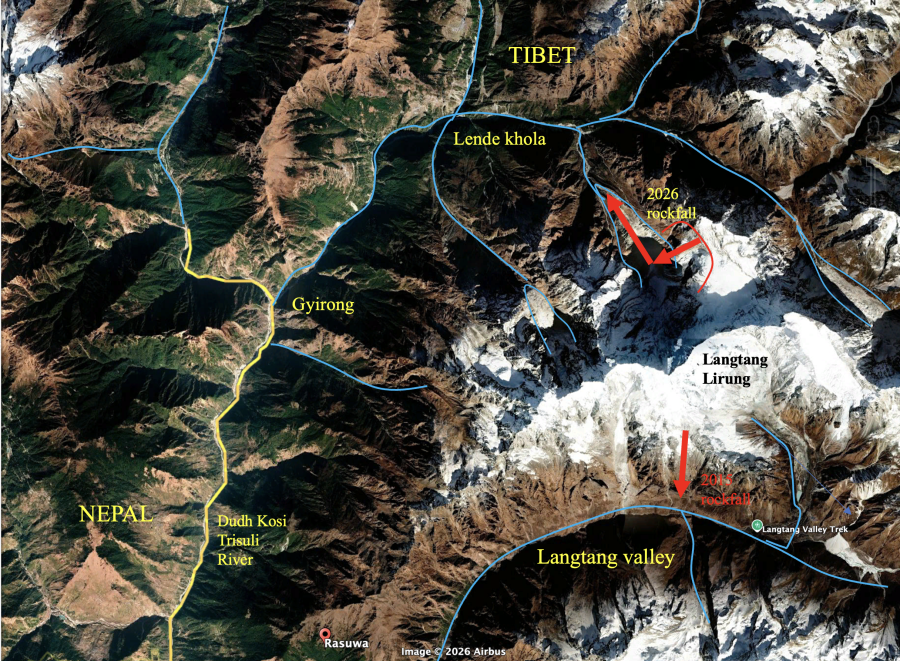
bookmark
Mike Searle
Published at : October 11, 2026
Updated at : October 12, 2026 06:45
The peak of Langtang Lirung (7,234 metres) has been the scene of several major disasters, the latest of which was the August 26 floods that rampaged along the Lhende and Bhotekoshi–Trishuli rivers. At 8:37am, a massive rockfall and glacier collapse from roughly 5,200 meters elevation occurred on the north flank of Langtang Lirung on the Nepal–Tibet border. The rockfall fell around 1,400 meters onto a lower glacier, the force of which pulverised the ice and caused an earthquake, initially registered by the US Geological Survey (USGS) at magnitude 4.4, later upgraded to 5.2.
The floods resulted in almost 1,500 deaths, and at least 5,000 people are still missing.
It was the worst natural disaster in Nepal since the April 2015 Gorkha earthquake, but it was not unprecedented. In 2025, the Miteri bridge across the Bhotekoshi River at Kerung, upstream from Rasuwa, linking the border post to Nepal, was washed away by a flash flood. The bridge was rebuilt in January 2026, only to be completely destroyed in the August 2026 flood.
2015 Gorkha earthquake
The Gorkha earthquake (magnitude 7.8) ruptured 150 km of the Main Himalayan Thrust, the basal detachment along which the Indian plate is presently underthrusting the Himalaya. Approximately 5-6 metres of horizontal shortening occurred during the earthquake, with around 1.1–1.5 metres of uplift of the mountains north of the Kathmandu Valley. On May 12, 2015, 17 days after the major earthquake, a large aftershock of magnitude 7.3 occurred at the eastern end of the rupture. This earthquake triggered hundreds of landslides, including the largest, catastrophic landslide on the south face of Langtang Lirung. The rock and ice debris descended 2,000 metres and completely buried the village of Langtang, killing over 300 people. There were no survivors.
Tsergo Ri landslide
The 2015 Langtang landslide was also not unprecedented. At the eastern end of Langtang Lirung, an entire mountain collapsed, resulting in one of the largest known landslides on Earth. The Tsergo Ri landslide was a huge rock collapse that occurred approximately 51,000 years ago. The mass of rock that collapsed has been estimated at 10-15 km3, more than five times larger than the slab of rock that collapsed on the north side of Langtang Lirung on August 26. The cause was probably an earthquake, but it could also have been a simple gravitational collapse of an unstable mountain. The remnants of this landslide, approximately 3 km3, remain around Yala peak, east of Kyanjin Gompa in the Langtang Valley.
Geological causes and consequences
The ultimate causes are both geological and climate-related. Rapid mountain uplift along the Greater Himalayas, yielding an increased local uplift of the mountain combined with rapid incision of the rivers along both flanks, resulted in over-steepened slopes which were prone to undercutting by the river. The peak of Langtang Lirung lies along the main Himalayan watershed and the axis of highest elevation along the Himalaya. To the east of Langtang Lirung lie the peaks of the Jugal Himal, Gaurishankar, Cho Oyu, Everest and Makalu. To its west lie the peaks of the Ganesh Himal, Manaslu, and the Lamjung–Annapurna range. Several large rivers cut through the axis of maximum elevation, including the Kali Gandaki, Marsyandi, Budhi Gandaki, Trishuli and Arun rivers.
Langtang Lirung has major river valleys to the north (Lhende) and south (Langtang valley) of the mountain. These rivers drain into the Bhotekoshi-Trishuli River, which drains south from the high plateau of Tibet and cuts right through the axis of high relief along the Himalaya. Mountain uplift is accompanied by river incision—the faster the rocks are uplifting, the faster the incision rates and downcutting of the river. Many rivers have kept pace with the uplift of the Himalaya and have incised back into the hinterland in southern Tibet, cutting right through the axis of high uplift. These rivers include the Bhotekooshi and Trishuli rivers, which rise on the high plateau of Tibet at ca. 5200 metres and flow south, cutting through the Greater Himalaya. River profiles show a steepening as the river cuts across the Himalaya. It is also possible that these rivers are antecedent, having formed prior to the rise of the Himalaya.
Global warming
Global warming has resulted in the recent rapid retreat of all Himalayan glaciers, and the melting of permafrost, which holds the loose rocks together at high altitude. The increasingly erratic monsoon rains have also had a major role in these disasters. In many cases, increased run-off from melting glaciers and snowfields has resulted in the formation of high mountain glacier lakes. Landslides can trap the river outflow, and a lake can build up. When eventually the lake bursts, it can result in a catastrophic, sudden release of water. This is exactly what happened in 2012, when a huge landslide occurred following the collapse of the west face of Annapurna IV. The landslide dammed a lake which burst three days later, causing a flood that cascaded down the Seti River, all the way to Pokhara. These glacial lake outburst floods (GLOFs) have occurred many times in the past, both on the Tibetan side of the Himalaya and in Nepal, emphasising the need for cross-border cooperation and information sharing.
Mitigation and future planning
Rockfalls, glacier collapse, earthquakes and floods are all part of the Himalayan ecosystem. Neither geological forces nor global warming can be altered in the short term, so instead Himalayan countries should mitigate these disasters with clear policies.
Seismic networks and GPS stations are now present across most of Nepal. Monsoon flood warning gauges were in place and working, bolted onto bridges along the Trishuli, but the flood took away the instruments and the bridges instantly on impact. More precise mapping of the major glaciers and river systems is required to monitor changes.
First, no houses or roads should be built on floodplains of any major rivers in the Himalayan region. Most deaths on August 26 were the result of people living along the river banks; this could have been easily prevented. Second, a major rethink on the energy policy, particularly large hydroelectric plants, like that being constructed at Rasuwa, needs urgent attention. Far better to build smaller-scale hydro schemes that serve individual towns and villages than major projects that will get wiped out by future landslides and floods. This has major implications for large-scale hydro schemes along the Arun River in Nepal and along the Yarlung Tsangpo River in Tibet. Thirdly, some sort of early warning system could be installed along the major break points such as the Trisuli River.
Finally, more detailed mapping of geological and glacial features along the highest peaks of the Himalayas is required to make an inventory of rivers, towns, and road systems that are in danger of future floods. A greater understanding of the links between mountain uplift, river incision, gravitational unloading, and the dynamics of glacial and fluvial processes is also needed. Most importantly, wealthy countries need to increase the amount of aid to Nepal to help relieve these frequent disasters. Coupled with the awesome beauty of the Nepali mountains come terrible natural disasters.
Mike Searle
Searle is a professor (emeritus) of earth sciences at the University of Oxford, UK.




Most Read from Columns
Before you take credit for Khula Manch, read its history
Shah went to the UN to speak for Nepal, then left before he could make the most of it
Why Nepal’s latest disaster needs a local name—not just a scientific label
Lesson learned after the death of Ronaldo
What Lubra can teach Nepal about climate-induced migration and resettlement
Editor's Picks
Constitutional Bench caught in seniority, ‘pick and choose’ dispute

A Dom boy’s long road to becoming a doctor

From blankets to handmade dolls, two foreign women bring comfort to flood survivors
News Analysis: When institutional defence exposes institutional fault lines

It’s a bird … it’s a plane … it’s the Indian ambassador’s farewell tweets
E-PAPER | October 12, 2026

×