How Nepal can take the global lead on Himalayan climate strategy
By championing predictive monitoring, resilient engineering and managed retreat instead of mere compensation, the country can reshape international climate policy for vulnerable mountainous nations. Reuters
Nepal’s upcoming high-level delegation to the United Nations General Assembly presents a critical opportunity to convert the destruction of the vital Lhende Khola–Bhotekoshi–Trishuli corridor into a sustained international framework for resilient mountain development. The government has clear moral and physical grounds to demand immediate financial mobilisation and global accountability. Domestic discourse has predictably coalesced around a familiar narrative: demanding climate justice based on Nepal's negligible contribution to global carbon emissions, paired with urgent appeals for post-disaster humanitarian aid. The state has explicitly framed its emergency interventions as a matter of global legal and moral liability—climate justice—rather than international charity. Because Nepal’s greenhouse gas footprint is minimal while it bears disproportionate, structural economic shocks from climate-driven glacial collapses, the nation is justly seeking accountability from global emission funds.
However, appealing exclusively to reactive compensation keeps Nepal trapped in a cycle of vulnerability. To lead effectively on the global stage, Prime Minister Balen Shah must present a proactive, structural roadmap that shifts the international paradigm from reactive aid to predictive hazard evaluation, climate-resilient engineering overhauls, and managed retreat from intolerable risk zones. Nepal must leverage the General Assembly floor, high-level bilateral sessions, and engagements with multilateral development banks to secure a dedicated, operational program for transboundary Himalayan resilience.
The scale of the catastrophe
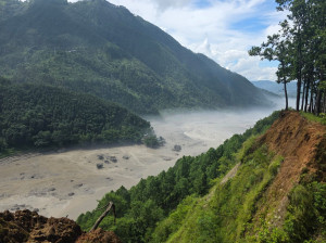
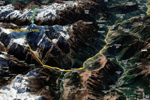
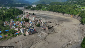
The debris surge caused an exceptional concentration of infrastructure losses. Approximately 60 kilometres of vital national highways, 37 motorable bridges, and over 50 suspension bridges were completely washed out. The primary overland trade artery between Nepal and China—the Rasuwagadhi border checkpoint and its foundational Miteri (Friendship) Bridge—was entirely wiped out, instantly paralysing cross-border commerce. The cascading hydrologic energy extended over 100 kilometres downstream to the Prithvi Highway, where severe toe-cutting along the Trishuli River caused a chronic, previously stabilised hotspot at Krishna Bhir to fail, causing a 100-metre segment of the highway to fracture and sink directly into the torrent.
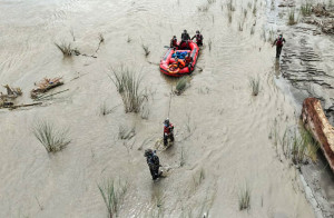
The economic shock was equally severe in the energy sector, damaging 13 major hydropower projects (10 operational plants and three under construction) representing a combined installed capacity of 783 MW, alongside the total destruction of a 25 MW solar power installation. The flood pulse obliterated critical transmission networks and a vital 220 kV substation at Trishuli, fracturing the central grid. The crisis left a large number of infrastructure workers trapped, missing, or cut off inside underground facilities, exposing severe vulnerabilities in subsurface communications, life-safety refuges, and emergency response protocols within narrow river corridors. Concurrently, the regional tourism, trekking and rafting sectors face massive cancellations due to destroyed trail networks, while localised public water utilities remain broken. Consequently, the Joint Rapid Damage and Needs Assessment (JRDNA), led by the National Planning Commission (NPC), has quantified the total recovery and reconstruction bill at a staggering $4.78 billion (approximately Rs723.31 billion).
A legacy of cascading mountain risks
Nepal’s history is defined by these destructive, cascading mountain hazards. The earthquake-induced Langtang avalanche in 2015 and the Thame Glacial Lake Outburst Flood (GLOF) in 2024 vividly illustrate how high-altitude physical failures propagate downstream into populated valleys. Similarly, the 1981 GLOF originating from the Zhangzangbu-Cho (Cirenmaco) lake in Tibet, China, devastated the Bhote Koshi–Sun Koshi corridor, wrecking international transport links. The 1985 Namche GLOF and the 2021 Melamchi debris flood—driven by thawing permafrost, degraded upper catchments, and intense precipitation—further demonstrate how changing temperature regimes alter alpine risk profiles.
Remarkably, this identical corridor was breached just last year, on July 8, 2025, when a supraglacial lake on the Purepu Glacier in Tibet suddenly burst, causing significant casualties and washing away the previous border bridge at the same crossing. Looking further back, geological research indicates that a monumental structural collapse within the Annapurna massif around 1200 AD released 23,000 million cubic meters of rock; this mega-avalanche travelled over 60 kilometres downstream, burying and reshaping the floor of the Pokhara Valley into the landscape that supports the city today.
The collective lesson of these historical events is clear: downstream safety depends entirely on environmental conditions situated far beyond the geographic boundaries of any single settlement, infrastructure project, or nation-state. While the distinct triggering mechanisms—whether earthquakes, extreme rainfall, or thermal shifts—must be explicitly mapped, our planning priorities must shift toward tracing how upstream failures propagate through whole river basins to minimise systemic vulnerability.
Proactive priorities for Nepal’s global agenda
Instead of focusing solely on post-disaster recovery and standard climate rhetoric, Prime Minister Shah's address at the UN should outline three concrete, proactive initiatives focused on predictive science, resilient infrastructure design, and risk-informed planned relocation.
First, Nepal must call for the creation of an international, UN-backed scientific consortium tasked with the continuous monitoring of high-altitude snow and glacier cover, bedrock stability, permafrost degradation, and expanding glacial lakes across the entire Himalayan arc. This body will oversee predictive modelling and institute mandatory transboundary data integration to relay early warnings across international borders to vulnerable downriver communities. Equipped with modern Interferometric Synthetic Aperture Radar (InSAR), high-resolution satellite remote sensing, and ground-based seismic arrays, this consortium will track active slope deformations and bedrock displacements before structural failure occurs. These predictive capabilities must link directly with national hydrometeorological stations, mapping unstable source areas, projected debris pathways, and exposed public assets while actively training and integrating Nepali personnel to ensure operational sustainability. For transboundary hazards along international borders, the delegation must establish protocols with China and India for round-the-clock data exchange and immediate, automated emergency alerts.
Second, critical infrastructure must be structurally designed to anticipate, absorb, recover from, and adapt to catastrophic alpine disruptions. Nepal should champion the global adoption of updated international engineering standards and rigorous, multi-hazard stress testing for high-mountain infrastructure, shifting away from outdated single-hazard design paradigms. Engineering criteria must explicitly incorporate worst-case scenarios, including extreme debris flows, landslide-dam outburst floods (LDOFs), intense sediment loading, cascading grid collapses, and total physical isolation. Given that highways, transmission lines, and powerhouses are often unsustainably clustered within narrow valley floors, Nepal should request bilateral partners and development banks to finance an immediate, joint vulnerability assessment of these co-dependencies, using the Bhote Koshi–Trishuli corridor as a global pilot. Future project appraisals must mandate strict spatial buffers, river setbacks, and structural redundancies—including alternative access routes, independent emergency communications, and secure underground worker refuges.
Third, reconstruction frameworks require difficult, data-driven decisions regarding where and when communities can safely return. Thorough scientific hazard assessments must precede permanent rebuilding in high-exposure locations, even as temporary shelter and essential medical services are deployed. When engineering interventions cannot reduce localised hazards to a manageable level, the state must implement managed retreat—the planned, dignified relocation of communities and infrastructure out of high-hazard active floodways. This must be framed globally as a core, eligible component of climate adaptation finance. Moving a community away from a hazardous river channel without providing secure land tenure, basic public services, and viable alternative livelihoods results in an incomplete recovery. Where risks are manageable and clearly understood, infrastructure investments should proceed only with enhanced safeguards; conversely, where climate risks remain intolerable, the project's location and design must be fundamentally changed.
Nepal cannot alter the intense geological forces shaping the Himalayas, but it can reshape its international climate strategy. By transitioning from reactive aid appeals to predictive hazard evaluation and risk-informed strategy, Prime Minister Shah can offer the international community a clear, credible framework for mountainous climate adaptation.




 16.67°C Kathmandu