National
India ‘notes’ passage of constitution amendment bill and continues to assert its territorial claim
The constitution amendment bill, which updates Nepal’s new map on the national emblem, was passed unanimously by the House of Representatives on Saturday.
Post Report
India said on Saturday that it has “noted” the passage of a constitution amendment bill to update the map in the national emblem by Nepal’s House of Representatives.
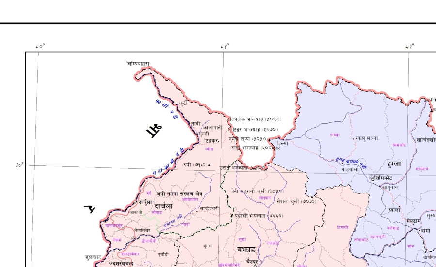
The Indian response follows the unanimous endorsement of the second amendment to the constitution of Nepal to update the country’s new political map, which includes Kalapani, Lipulekh and Limpiyadhura within Nepali territory, in the national emblem.
All 258 lawmakers present at Saturday’s House meeting voted for the bill. There was no vote against it.
"We have noted that the House of Representatives of Nepal has passed a constitution amendment bill for changing the map of Nepal to include parts of Indian territory,” said Anurag Srivastava, spokesperson for India’s Ministry of External Affairs. “We have already made our position clear on this matter.”
The territories are claimed by India as its own.
“This artificial enlargement of claims is not based on historical fact or evidence and is not tenable. It is also violative of our current understanding to hold talks on outstanding boundary issues," said Srivastava.
The Nepal government on Tuesday had presented the bill in the Lower House for theoretical discussion. The House then unanimously endorsed a proposal to consider a second amendment to the constitution the same day.
The Cabinet, on May 20, had issued a new administrative map of the country incorporating Limpiyadhura, Lipulekh and Kalapani, all territories disputed with India, into Nepali territory. The government, two days later, registered a bill in Parliament, seeking to amend Schedule 3 of the constitution to update Nepal’s new political map in the national emblem.
Nepal decided to release its new political map after India earlier last month opened a link road via Lipulekh to Kailash Mansarovar in the Tibet Autonomous Region.
The Nepal government has based the new map on the Sugauli Treaty signed between Nepal and British India in 1816, which states that all lands east of the Kali River belong to Nepal. While Nepal has argued that Limpiyadhura is the origin of the river, India has claimed Kalapani as the source.
In 2015 too, when Nepal’s Constituent Assembly promulgated the constitution, New Delhi had “noted” the event, in what was indicative of India’s displeasure with Nepal’s adoption of a new charter.
India subsequently imposed a more than five-month-long blockade, resulting in shortages of supplies in Nepal, including essentials like medicines.
Nepal-India relations saw a historic low.
The two countries were trying to reset ties by enhancing high-level exchanges, but back in November, the publication of a new political map by India after New Delhi repealed Jammu & Kashmir’s special status prompted protests in Nepal, as it placed Kalapani within its own borders.
Nepal has time and again sought dates for talks to resolve the issue, but Delhi has ignored all calls.
The recent tensions in Nepal-India relations flared up after India announced a road link via Lipulekh on May 8.


 9.12°C Kathmandu


