National
Even as pressure mounts, Oli administration remains silent over Kalapani
A new map released by the Indian government has placed Kalapani inside Indian borders, drawing widespread condemnation on social media.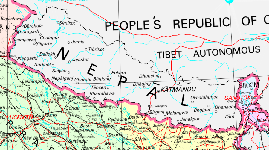
Anil Giri
The KP Sharma Oli administration has remained silent over a new political map released by India that places Kalapani, a disputed tract of land between Nepal and India, within Indian borders.
The Post first reported on Monday about the Indian government’s new map, released by the Indian Ministry of Home Affairs, which has since ignited a social media storm. But the ruling Nepali Communist Party, which had contested the 2017 elections as a nationalist force in the wake of the 2015 Indian blockade, and the Ministry of Foreign Affairs has yet to take a public position, although discussions were ongoing late into Tuesday.
The Parliament’s State Affairs and Good Governance Committee has taken note of map and will summon concerned officials to discuss the matter, said committee member Pampha Bhusal.
A Tuesday meeting of the committee decided to summon officials from the Ministry of Foreign Affairs, the Home Ministry, Ministry of Land Reform and Management, and the Survey Department on Thursday.
“We’ve learned that the new Indian map has placed Kalapani in its territory, but we want to know the government’s position and what it is doing,” Bhusal told the Post.
A number of political parties and elected representatives from Darchula district, which includes Kalapani have sought the government’s official position on the issue.
Ganesh Singh Thagunna, a Member of Parliament from Darchula from the ruling Nepal Communist Party, said he was opposed to the Indian move but that it is the job of the government to raise the issue with New Delhi.
“I am concerned as the elected people’s representative. I came to know that our land has been placed in Indian territory,” said Thagunna. “The government should take immediate steps with India and raise the issue through diplomatic channels. We have to put pressure on the government to tell India to correct the map.”
The Post repeatedly reached out to Foreign Minister Pradeep Gyawali, Foreign Secretary Shankar Das Bairagi, Spokesperson at Foreign Ministry Bharat Raj Paudyal, and ruling party Spokesperson Narayan Kaji Shrestha but they were unavailable for comment. Shrestha told the Post that he was travelling outside Kathmandu and was not aware of the new Indian map.
One Foreign Ministry official, who did not wish to be named as he was not authorised to speak to the media, said that the ministry was trying to verify the new Indian map—it was released after India formally split up the disputed Jammu and Kashmir state into two federal territories—before taking an official position.
“Since this is a serious diplomatic issue related to our boundary, there is a mechanism at the foreign secretary-level to look into the matter, so it will deal with the issue accordingly,” the official said.
Senior officials at the Survey Department examined the new political map of India on Monday and Tuesday and reconfirmed to the Post that Kalapani has been placed inside Indian territory. Although Kalapani was once comfortably in Nepali territory, since 1962, it has been occupied by the Indian armed forces, according to historians and surveyors.
The Survey Department was supposed to brief higher authorities, including the Ministry of Land Reform and Management, and the Ministry of Foreign Affairs on Tuesday but officials were unable to get time with ministry officials, they said.
“We hope we will get time for a briefing soon as there is a lot of pressure on us and other government entities,” said a senior Survey Department official who requested anonymity, citing sensitivity of the issue.
Bishwa Prakash Sharma, spokesperson for the primary opposition Nepali Congress, said that the party’s attention has been drawn to the new map released by New Delhi.
“Kalapani and Lipu Lekh are our inalienable parts. The Nepal government should take immediate steps and make its position public. Questions being raised about our soil from anywhere are objectionable and unacceptable,” he said on Twitter, addressing the prime minister.
Two political parties—the Rastriya Prajatantra Party and the Nepal Majdoor Kisan Party—also issued press statements on Tuesday condemning the Indian map and seeking an official explanation from the government and Prime Minister KP Sharma Oli.
Dinesh Bhattarai, who served as foreign affairs advisor to the late Sushil Koirala, told the Post that the Koirala government, in 2015, had protested with India and China after the two countries decided to develop a bilateral trade route through Lipu Lekh, a tri-juncture between Nepal, India and China, and closed off the Kalapani area.
“The decision was made in May 2015 and in June, we protested to both India and China,” said Bhattarai. “But none of the so-called nationalist governments formed after the Koirala government has taken up the issue with India and China.”
Bhattarai said the government first has to to make its position public and then the ruling and opposition parties should both raise the issue.
“What we are waiting to see now is if they have the guts to raise the issue,” he said.


 18.12°C Kathmandu
