National
Avalanche caused Seti flash flood: NASA
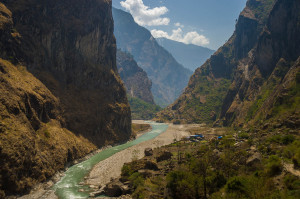
The disastrous Seti flash flood that claimed 72 lives and left dozens homeless less than two years ago was the result of a rockslide in the Seti-River gorge
The disastrous Seti flash flood that claimed 72 lives and left dozens homeless less than two years ago was the result of a rockslide in the Seti-River gorge which created an artificial reservoir, according to the latest field research by the US-based National Aeronautical System Administration (NASA).
The deadly event that happened on the morning of May 5, 2012 in Pokhara Valley’s Seti River was the result of an ‘artificial reservoir’ formed due to the damming of snow and ice melt which was later aggravated by a mighty avalanche on Annapurna IV. The Seti River originates from the Seti Gorge situated between Mount Annapurna and Dhaulagiri ranges in Kaski district.
The article, written by University of Arizona hydrologist Jeffrey Kargel and published on Friday in the Earth Observatory, a NASA affiliated publication, reaffirmed what many believed to be the case.
Before and after satellite images have revealed that the Seti Gorge, the origin of the Seti River in the foothills of the Annapurna IV mountain range, had experienced smaller rockfalls and other erosion events over the previous decade, though the larger instance, occurring on May 5, was almost certainly responsible for the disaster.
Soon after the occurrence of the Seti flash flood, experts representing national and international scientific communities expressed their views regarding the likely cause of the catastrophic incident, with some categorising it as a Glacial Lake Outburst Flood.
According to the latest findings shared by Kargel and based on information gathered from frequent field visits, satellite images and local interviews, the research team observed direct evidence of avalanche-boulders and streams of debris emanating from the base of Annapurna IV to the head of the enormous Seti River Gorge. Kargel, who is also a hydrologist with Global Land Ice Measurements From Space, a project designed to monitor the world’s glaciers using data from optical satellite instruments such as ASTER (Advanced Spaceborne Thermal Emission and Reflection Radiometer) has indicated that although the incident was terrifying and deadly, by geologic standards its magnitude was modest. The high death toll was due to residential dwellings along the vulnerable areas of the lowest terrace and on the floodplains along the river. Kargel further mentioned that the findings do not bode well for the future of small settlements scattered along the riverside, arguing that there is a strong case for the resettlement of these communities.


 9.12°C Kathmandu


