



 17.28°C Kathmandu


Tue, Oct 27, 2026
Columns
Why Kathmandu is drinking blind
A technique that maps aquifers from the air is changing how countries protect their drinking water. Nepal needs to adopt this method.
bookmark
Kapil Karki
Published at : October 27, 2026
Updated at : October 27, 2026 01:51
In February 2023, all three deep borewells at Tribhuvan University Teaching Hospital in Maharajgunj ran dry. More than 300 feet deep, one had supplied the hospital for nearly 40 years. Today, despite treating thousands of patients daily, the hospital relies on water tankers and a pilot rainwater-harvesting initiative to meet its needs.
When a well runs dry, we often blame over-extraction. But a more fundamental question remains unanswered: What lies beneath the Valley? Where are the water-bearing sand and gravel layers? Where does clay restrict groundwater flow? And where does rainwater seep back in? Without understanding this underground landscape, every new borewell is a gamble, and groundwater policy is built on incomplete knowledge.
Nepal understands the importance of studying the ground before building on it, yet we have invested far less effort in understanding the groundwater we drink and what it contains. Beyond arsenic, nitrates and faecal bacteria, groundwater is increasingly investigated worldwide for PFAS (forever chemicals), pharmaceutical residues, pesticides, microplastics and industrial solvents. We know little about the presence and distribution of many of these pollutants in Nepal.
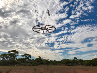
Airborne electromagnetic (AEM) surveying could help close this knowledge gap. The method is remarkably simple in principle. An aircraft carries a large loop of wire that generates electromagnetic pulses, inducing electrical currents in the ground. A receiver records the magnetic response as these currents decay. Because clay conducts electricity better than clean sand and gravel, the resulting signals help distinguish between subsurface layers. By analysing these responses, we can map the clay cover, identify where it thins and trace faults hundreds of meters below the surface.
By mapping subsurface electrical properties, AEM can reveal aquifers, sand and gravel deposits, clay barriers and potential recharge pathways. While it cannot directly detect individual pollutants, it can identify vulnerable zones, trace potential contamination pathways and guide targeted groundwater sampling. Combined with borehole investigations and laboratory testing, AEM can help us understand not just how much groundwater the Valley holds, but where it moves and what it contains.
Memphis, Tennessee, in the US, offers an interesting contrast to Kathmandu: almost all its drinking water comes from underground, from a sandy formation known as the Memphis aquifer. A thick clay layer above it acts as a natural protective barrier, separating the aquifer from shallow groundwater and surface contamination. But this protection is not uniform. Where the clay thins, breaks or is displaced by faults, water from above can seep through, potentially carrying contaminants with it. Mapping these weaknesses through individual boreholes would take years, if not decades. Instead, an AEM survey was conducted across the region in 2021 and 2022.
Kathmandu Valley is, geologically, a close cousin of Memphis. Both sit in ancient sedimentary basins, where layers of sand, gravel and clay shape how groundwater is stored and moves. Hydrogeologists describe Kathmandu’s groundwater system as having two main levels. Near the surface, particularly in the northern and central Valley, a shallow sand aquifer receives water from rainfall and rivers. Beneath it lies a thick layer of lake clay, known locally as kalimati, which separates the shallow system from a deeper aquifer of sand and gravel. Most deep borewells tap this lower aquifer, which is recharged mainly along its northern margin, where the sediments meet the surrounding hills. Beneath parts of southern Patan, groundwater moves so slowly that studies have identified a largely stagnant zone.
Groundwater depletion is reported to be more severe in the central Valley and less pronounced in the north. This pattern is consistent with geology: the north is an important recharge area, yet its open land is steadily being replaced by roads and buildings. An AEM survey could help establish how continuous the clay layer is, where the deeper aquifer extends and which recharge areas are most vulnerable to urban development.
The Tarai belt faces a similar challenge on a much larger scale. Its aquifers receive substantial recharge through the coarse sediments of the Bhabar belt, along the foothills of the Chure range. Yet this critical recharge zone is under pressure from quarrying, deforestation and expanding settlements. Active faults also cross parts of this region, but their influence on groundwater movement remains poorly understood. Meanwhile, farmers across Madhesh are increasingly dependent on groundwater, particularly during the dry season.
India’s National Geophysical Research Institute has developed helicopter-borne AEM surveys for groundwater investigations, and similar methods are used internationally. A regional survey requires investment, but so does repeatedly drilling failed borewells, supplying hospitals and municipalities with tanker water, and bringing water from distant sources through projects such as Melamchi. Understanding the resources beneath our feet is a worthwhile investment, not an additional expense.
Four practical steps could move this forward. First is conducting a pilot AEM survey of the Valley. The Groundwater Resources Development Board and Kathmandu Valley Water Supply Management Board could lead the effort, using existing borehole records and the recent geotechnical model to validate the results. Similarly, it is important to create an open national borehole archive. Drilling companies, consultants and government agencies hold thousands of borehole logs. Valuable subsurface information remains scattered across individual projects. Digitising and sharing these records would create an invaluable national resource.
Third, Nepal must protect its groundwater recharge zones by using geological and geophysical maps to identify vulnerable areas in the northern Valley and along the Bhabar belt before further urbanisation and land degradation compromise them. Finally, building national expertise in airborne geophysics is vital. Nepali universities and government agencies should develop the capacity to acquire, process and interpret these datasets locally.
Nepal still has much to learn about the ground beneath it. Earthquakes, landslides and floods have taught us, often painfully, to see that ground as a hazard. Hydropower and roads have taught us to study it as an asset. Yet the geology that holds our drinking water remains largely unmapped. Groundwater is critical infrastructure, even if we cannot see it. We should understand and protect it before the wells run dry, not scramble to investigate it afterwards.
Kapil Karki
Karki is a PhD candidate in Earth Sciences at the University of Memphis, USA, where he studies groundwater systems and fault structures using airborne geophysics.

Most Read from Columns




Editor's Picks

What to know about the US trial over Mamta Kafle’s disappearance
NPL returns with bigger ambitions and global recognition
What’s new in the Nepal Premier League’s third season?
After Nepal’s recent disaster, it wants to test whether COP31 can deliver climate justice
Why does an hour long flight to Dhangadhi cost more than a flight to New Delhi?
E-PAPER | October 27, 2026

×