



 18.6°C Kathmandu

Fri, Oct 23, 2026
Columns
Nepal must turn satellite observations into early warnings
If scientists can detect potentially significant deformation after an event, why is there no operational system routinely monitoring for similar changes before disaster strikes?
bookmark
Chandra Giri
Published at : October 2, 2026
Updated at : October 2, 2026 08:01
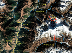
The catastrophe that swept through the Lhende Khola–Bhotekoshi–Trishuli corridor on August 26, 2026, exposed not only the growing instability of a warming Himalaya, but also a dangerous gap between what modern science can observe and what our institutions are prepared to do with that knowledge. Closing that gap must become a national priority for Nepal and a regional priority across the Hindu-Kush Himalaya.
The Himalayas are exceptionally difficult to monitor. Nepal cannot place technicians and instruments on every glacier, unstable slope or high-altitude river. Many locations remain inaccessible for months. Ground instruments are costly to install and maintain, and floods or landslides can destroy the very gauges designed to detect them. The challenge is also transboundary: hazards may originate beyond Nepal’s borders while threatening communities, roads, bridges, hydropower facilities and trade routes inside the country.
For terrain this vast, satellite remote sensing is indispensable. But satellites alone do not save lives. A scientific signal becomes useful only when someone is continuously looking for it, qualified experts can interpret it, authorities know what action to take and exposed communities receive a warning they understand and trust.
In response to the Rasuwa tragedy, a webinar titled “The Himalayan Tsunami: Science, Technology and Innovation for a Safer Nepal” was held on September 18, 2026. The event brought together Nepali and international experts in remote sensing, mountain science, Earth observation, disaster risk reduction, technology and public communication. The discussion was encouraging. It showed that considerable expertise already exists among scientists in Nepal, the Nepali diaspora, international universities and institutions such as ICIMOD.
During the webinar, Virginia Tech geophysicist Professor Manoochehr Shirzaei reported that satellite radar images suggested part of the glacier-rock system had been moving and accelerating in the weeks before its collapse. His preliminary analysis of Sentinel-1 radar data taken from January 8 to August 18 (until a week before the incident) detected movement of roughly 10 millimetres per month near the apparent failure zone. He also cautioned that the precise sequence of events remained uncertain and that such movement, considered in isolation, would not necessarily predict an imminent catastrophe.
Another presenter, Robert Rohde, chief scientist at Berkeley Earth, reported that his team had analysed meteorological conditions surrounding the August 26 collapse and subsequent flash floods in Nepal and Tibet. The analysis indicated exceptional heat at the high-altitude site immediately before the disaster—conditions that may have contributed to the rock-and-ice avalanche.
Average temperatures at the collapse site, located at an altitude of approximately 5,200 metres, reached roughly 5 degrees Celsius between August 21 and 26. This level of heat was unprecedented for that specific time of year; temperatures during this six-day window had never exceeded 4.0 degrees Celsius in more than 55 years of historical records.
This distinction is important. This research does not prove that the August 26 disaster could have been predicted with certainty. It does, however, raise an urgent question: If scientists can detect potentially significant deformation after an event, why is there no operational system routinely monitoring for similar changes before disaster strikes?
Early-warning systems require continuous data acquisition, automated analysis, trained staff working under clear protocols, predefined alert thresholds, rapid human verification and an institution authorised to act.
To achieve this, Nepal needs a multi-scale approach. The country has capable scientists and agencies, but the chain connecting observation, interpretation and public warning remains fragmented. Furthermore, Nepal alone may not be able to achieve this goal. It should connect its national warning system with existing international Earth-observation research and operational monitoring networks.
An effective Earth observation system would integrate radar, optical, thermal, hyperspectral and lidar observations. Synthetic aperture radar can observe through clouds and darkness and measure subtle ground deformation. Optical imagery can reveal changes in glaciers, lakes, river channels and slopes. Thermal data can help identify unusual melt or freeze-thaw conditions. Hyperspectral imagery can distinguish snow, ice, water, vegetation and surface materials in greater detail. Periodic LiDAR surveys can produce precise terrain models and measure changes in unstable valleys. Geostationary satellites provide frequent observations of weather systems, while sun-synchronous satellites provide more detailed repeat coverage.
“Fortunately, much of the necessary satellite data is freely available,” said Barbara Ryan, former Executive Director of the Group on Earth Observations (GEO), during the webinar.
Artificial intelligence (AI) can compare observations from multiple sensors, detect acceleration or unusual change, and rank locations for expert review. It can reduce the impossible task of manually examining thousands of images to the manageable task of investigating a smaller number of anomalies. AI should be used to prioritise anomalies for expert review—not to issue public warnings without human verification.
During the webinar, engineer Abinash Silwal presented preliminary results from reconstructing the disaster using Earth observation data and advanced analytical methods. These findings could help scientists better understand the event and inform future monitoring efforts.
Basanta Shrestha, former Director of Strategic Cooperation and head of the MENRIS program at ICIMOD, noted that “ICIMOD has been using satellite data to monitor glaciers for 30 years, but a new approach is now needed.”
The Nepal government should consolidate, update and operationalise existing inventories of glaciers, unstable rock-ice slopes, moraine-dammed lakes and landslide-prone valleys. High-risk locations should be analysed whenever new radar or optical data become available, daily where suitable imagery exists and as frequently as technically possible elsewhere. Commercial imagery should be purchased selectively when free satellite data reveal concerning changes. Additionally, satellite monitoring must be connected to ground truthing. Automatic weather stations, river gauges, seismic and acoustic sensors, cameras, and GNSS instruments should be installed at the highest-risk sites.
Nepal also needs a 24/7 operational warning desk with legally defined responsibilities. An anomaly in satellite data should automatically open a case, trigger expert review, and, when necessary, place downstream authorities on watch. The country must establish formal partnerships with regional and international scientific institutions to share near-real-time satellite, meteorological, hydrological and seismic information.
Remote sensing cannot prevent glaciers from collapsing or mountains from moving. Nor can it guarantee that every disaster will be predicted. But it can reveal changes in places human observers cannot reach, provide precious time for investigation, and guide warnings before a hazard becomes a catastrophe.
The technologies already exist. The next task is to connect satellites, scientists, authorities and communities into one continuous chain—from observation to decision and from warning to safety.
Chandra Giri
Giri is a Senior Advisor at the US Environmental Protection Agency & Adjunct Professor at Duke University.





Most Read from Columns

Editor's Picks
E-PAPER | October 23, 2026

×