 20.13°C Kathmandu

Sun, Jul 26, 2026
Columns
Prepare for emerging weather challenges
We need response strategies for both the monsoon deluge and the winter drought.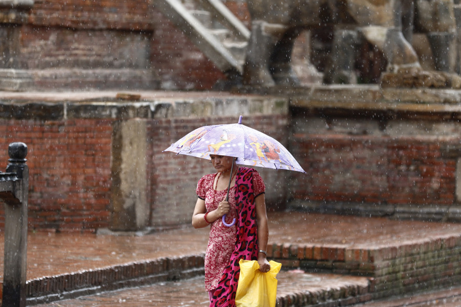
bookmark
Madhukar Upadhya
Published at : May 18, 2025
Updated at : May 18, 2025 20:11
According to a regional climate forecast, this year’s monsoon will likely be above-normal, meaning we will face an increased risk of extreme events. Although the government of Nepal has yet to downscale the prediction, the forecast will, in theory, help national authorities formulate strategies and plan for disaster responses in advance.
Most of our disaster responses in the past focused on rescue and relief operations and not much on reducing the anticipated risks, except for limited early warnings in case of floods to minimise imminent deaths. Emerging weather patterns now require the development of opportunity-leveraging strategies to avert these risks. Given how monsoon-related disasters have intensified in recent years, the above-normal monsoon forecast has come well in advance, primed to motivate decision makers to develop such strategies.
The other side of the story is equally nerve-wracking. We are increasingly facing a slow-onset disaster—the winter drought. The last three winters have been practically rainless. Damage caused by winter droughts isn’t as abrupt or obvious as that of the monsoon floods or landslides, but it’s widespread and lasting and, hence, in no way less serious. Its impact on agriculture, dairy and energy production affects the overall economy. Water shortages lead to poor sanitation, disease outbreaks and pollution caused by rampant wildfires. The combined cost of winter droughts could be severe, yet it hasn’t become part of our disaster preparedness or climate discourse to the extent it deserves.
Uncommon atmospheric phenomenon
There has been a significant shift in the nature of rainfall, with increased frequency of heavy rains even during normal monsoons, let alone during an above-normal one, and new atmospheric phenomena bringing forth
cataclysmic rains. Recall the monsoon of 2017. It rained for three consecutive days in Tarai, causing simultaneous floods from Jhapa to Bardiya—an unusual occurrence. In 2018, the Indian state of Kerala had a similar experience when the clouds disembowelled all their moisture over the southern state for nine consecutive days, causing a ‘flood of the century’. Sadly, these were not isolated events. Now we better understand why this trend of weather systems becoming stuck in confined areas has been on the rise.
We even saw it in Spain last October. Torrential rains, causing one of the deadliest floods in modern Spanish history, were triggered by an isolated low-pressure area, called a cut-off low, which detached from the main upper-level jet stream flow. The weather front in such a situation is essentially fixed in one location, bringing heavy precipitation for days. Another uncommon atmospheric phenomenon called the Omega Block has been known to bring heavy rains in a confined area for several days. In this case, two low-pressure systems become stalled on either side of a high-pressure area, resulting in a stuck weather pattern. The recent floods in northern Mexico on May 9 were linked to this uncommon phenomenon, bringing more than 110 mm of rain over a few hours.
We don’t know if any such uncommon atmospheric phenomena were responsible for the unprecedented rains that deposited massive amounts of debris in the intake area of the Melamchi project in 2021 or the late September rain in central Nepal last year that dumped heavy rain in the Phulchoki area causing colossal floods and debris flow in Roshi river that swept away a large section of the BP Highway. What we know for sure is that the atmosphere is already capable of holding more moisture due to rising temperatures. It’s worth noting that several days in 2024 crossed 1.5 degrees Celsius—the threshold set by the Paris Agreement. There is a good chance that 2025 will have average temperatures of 1.5 degrees Celsius.
Regarding the winter drought, it is believed that the weakening of the jet stream, primarily due to the warming of the Arctic and the subsequent impact on the polar vortex, has suppressed the westerlies that bring winter precipitation to our region. The polar regions will continue to warm, and so will the likelihood of the westerlies being suppressed further. The continued effect of a warming Indian Ocean will also worsen the possibility of more winter droughts. What it means is we are facing disasters in both seasons.
Extreme weather-focused preparedness
While we continue to applaud national efforts of convincing the global community of increasing climate impacts we’ve faced and the issues of the mountains, what matters is our capacity to understand the happenings across the country and how our institutions and communities can prepare for any eventualities. Given the changing atmospheric phenomenon, we need to focus more on, in addition to the retreating glaciers and expanding glacial lakes, how to avert risks in the Tarai if hit by 2017-like floods, in the hills by increasing debris flow, and in the valleys by a sea of mud that affect large numbers of people during the monsoon. Likewise, we must understand how people have coped or failed to cope with drying springs in the hills and the falling groundwater levels in the Tarai before addressing these growing risks.
Ordinarily, our water-related problems could be summarised by the saying ‘too much water’ during the monsoon and ‘too little water’ during the winter. However, this asymmetric distribution of precipitation has skewed acutely in recent years. The above-normal monsoon that we are awaiting could be followed by another long, dry winter in 2025-26 for the same reasons that suppressed the winter precipitation system from moving east of Karnali province in the three preceding years. So, our disaster preparedness now needs to be both monsoon- and winter-focused as the problems are becoming acute in both seasons with progressively increasing economic and social repercussions, leaving a very short period in between for preparation.
In lockstep with the surprising changes
The emerging weather systems aren’t what they used to be. As the uncertainty reaches a boil, conventional ways of approaching disaster preparedness are no longer suitable. Considering the entire year’s climate extremes, the best approach is to have response strategies for both the monsoon deluge and the winter drought. The day we begin addressing the asymmetric distribution of precipitation as a package using an opportunity-leveraging strategy, we will be in a better position to tackle climate change. The purpose of weather forecasts, the reliability of which has increased remarkably in recent years, is to inform decision makers of all relevant sectors, including agriculture, infrastructure, public health and communities, and prepare for threats by taking precautionary measures. Recognising the resource limitations, we still have enough time before the monsoon becomes active to test the effectiveness of this comprehensive approach.
Madhukar Upadhya
Upadhya is a senior watershed expert.


.png&w=200&height=120)
Most Read from Columns


Editor's Picks

Proposed ‘Romeo and Juliet’ law may spare boys, but what about girls?

Three prime ministers, 10 premierships. Why is Sudurpaschim still Nepal’s poorest province?

Inside the strange, disciplined, unreachable world of Nepal’s Prime Minister

Three credit booms in three decades ended in economic downturn

How Nepal could lose a generation of footballers due to FIFA’s suspension
E-PAPER | July 26, 2026
×