 22.13°C Kathmandu
Tue, Mar 17, 2026
Opinion
Cities without addresses
The marked absence of street addresses in Kathmandu points to a persistence of traditional dwellings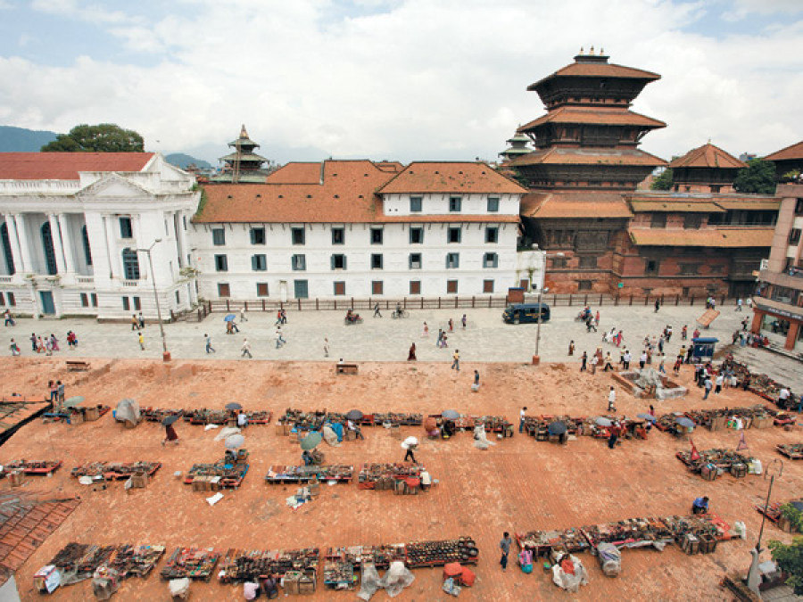
bookmark
Published at : January 26, 2015
Navigating Kathmandu or in any other city of Nepal, both in and outside the Kathmandu Valley, and trying to locate a friend’s house is an unforgettable experience. Contrary to most urban conurbations in the West, but like in many other Asian countries (such as Japan), no address as such exists for any of the houses. There are postal addresses, a number written on the side facing the street, but this is used mainly for postal and tax purposes. This is a mark for Census or cadastral registration purposes, rather than a means of finding your bearings within the city. A friend you are visiting would never give you this information to find his house. Instead, he would provide you with the name of the neighbourhood. Similarly, in new extensions, most of the streets have no names or if they do, these names have mostly never been heard of.
Finding direction
To find somebody’s house, especially in densely populated areas, you have to play detective and be patient. The best solution, of course, is to be able to contact your friend with a mobile phone so that they can guide you step-by-step. They can also communicate in this way with your taxi driver, supposing that you have one. After various attempts and hesitations, you will finally reach your destination. The search is particularly difficult because over the last decades, anarchic urban development has created a multitude of unnamed lanes and alleyways that are difficult to recognise if you yourself do not live in the neighbourhood. Furthermore, a street map, if you are lucky to get one, will be of no real help. The difficulties get worse, of course, at night time when there are no visual landmarks, especially if you disturb some innocent dogs resting in the street that seemingly rule over the territory, hotly defending it against all sorts of unknown visitors.
Your task will no doubt be less difficult in old historic centres. Despite the complicated structure of buildings surrounding a series of inner courtyards, a chowk, linked together by dark narrow passages, there are well-known landmarks to locate your position and your friend’s house. Some lanes may even have names (in Nepa Bhasa) derived from their straight or curved form or other physical appearances. The old pre-modern streetscape is replete with Ganesh and Devi temples, which are there to guide you. Moreover, in old networks of houses, each neighbourhood (and in most cases each courtyard) has a specific name. Besides, once you find yourself in the right neighbourhood, you will be more likely to find somebody who recognises the name of your friend and who can direct you to their house. Local orientation schemes can tell us much of the ways in which urbanites think about urban space.
Structured, unstructured
After all, it is a well-known fact that these old historic cities in the Kathmandu Valley are structured like a mandala, ie, a miniature cosmogram aligned with the cardinal directions and providing a bridge between the macrocosm and the microcosm. The space is theoretically arranged (or, at least, is thought to be arranged) according to this type of cosmological model. Most researchers have convincingly demonstrated that cities such as Lalitpur, Kathmandu, and Bhaktapur are structured according to geometric devices and to the location of temples, like a mirror of the whole cosmos to which the city is supposedly related. In some cases, the main lanes are arranged according to an orthogonal layout with recurrent right angles. This street pattern helps to locate houses much more easily than curved lines and winding streets.
Suburban areas have an entirely different morphology. In these recently built neighbourhoods, you have to make your way through an unstructured no man’s land with few landmarks to help you track down a house. Schools (which do have names), shops, trees (if they have not been cut down), or bridges serve as landmarks. Yet, the suburbs lack the unity that characterises the urban space in the heart of cities, even if at first sight, the latter seems secret and hidden away. Suburban communities are surprisingly less closely knit. People know less about each other and therefore, cannot help you—indeed, they are likely to get you even more lost.
Chaotic ensemble
Many years ago, while working alongside three French architects, I studied how, at the intersection of transport axes, a city (Panauti) had extended beyond the gates of its old town (dhoka) and former boundaries. The ensuing monograph demonstrated that in these new areas, the ancient organic unity of the spatial system and the wall-to-wall corridor structure of traditional dwellings rapidly disappear. Space is disorganised and life’s economic necessities are disconnected from socio-religious functions. The symbolic meaning of the old dwelling, which was structured according to common religious practices, has almost vanished. The purely economic logic (the ability to buy an expensive piece of land to build a house) has engendered a chaotic ensemble that remains outside a pre-ordained traditional social space. Some well-off residential areas with houses (often named) surrounded by a garden are an exception.
The absence of a proper address for houses in pre-modern towns is understandable. In these areas, the quality of space was traditionally subordinated to social units and the various functions of a dwelling—religious, economic, and social—merged. As a matter of fact, people living in these tols do not feel the need to give every street a name. They have a clear mental map of the area and a good network of nearby relatives and neighbours, which compensates for the lack of names for roads or lanes. Such a situation parallels many other former pre-industrial towns throughout the world. Nevertheless, the lack of a proper address is more surprising and—to put it plainly—irritating in the suburbs where ancient spatial features have been lost and where old landmarks have disappeared.
The marked absence of a standard visible system of labelling streets points to two interrelated features. On the one hand, it reveals the persistence of traditional dwellings and native/indigenous modes of space conceptualisation to guide people in their daily lives. Strikingly, in old city centres, urbanites have their own particular perception of the city and their own winding itineraries along narrow snaking paths/alleys beyond the main axes. On the other hand, this dearth reveals the weakness (and the lack of interest) on the part of the state and municipalities in establishing a set nomenclature: at local level, a stateless appropriation of living space still prevails.
Toffin is Research Professor at the National Centre for Scientific Research, France


Most Read from Opinion


Editor's Picks

Can Gagan Thapa convince Nepal that experience still matters?

How Facebook’s algorithm is amplifying one party over all others
Five and half decades of KP Oli in Nepali politics

Nepal’s IT exports near $1 billion. Can the momentum be sustained?

Parties’ lofty pledges on economy collide with hard realities
E-PAPER | March 17, 2026
×