Columns
Map politics in South Asia
The bilateral agreement on the trilateral junction of Lipulekh is a case in point.
Lok Raj Baral
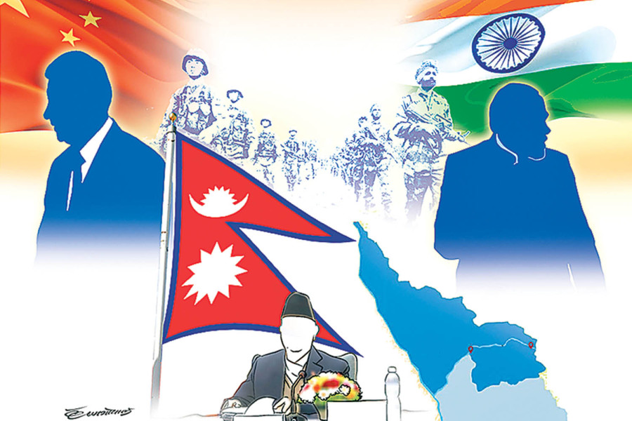
Nepal seems to have fallen into the trap of map politics that also involves China and India. Border disputes involving the three countries had begun since the early 1960s, particularly following the Sino-Indian border war in 1962 and with the knowledge that Indian troops had been stationed in the Kalapani area of Nepal. It has been learned that this was brought to the notice of the then King Mahendra, who was stated to have suggested not raising this issue knowing the drubbing India received at the hands of the Chinese in the 1962 border conflict.
Almost forgotten for a long time, Kalapani came to public discussion in the 1990s when Nepal had urged India to vacate the occupied area whereupon both countries had agreed to settle the issue through diplomatic channels. The foreign secretaries of the two countries were asked to look into the Kalapani issue and other border-related problems. However, no substantive progress has been made as yet. On the contrary, a new dispute has arisen following the Indian government’s decision to issue a map claiming the entire Kashmir and Uttarakhand areas, including the disputed territories of Kalapani, Lipulekh and Limpiadhura. In reaction to the Indian map, the Nepali side also claimed the entire territory east of the Kali River, stretching from Limpiadhura to the Kalapani area. According to the Nepali version, Article IV of the Treaty of Sugauli 1816 clearly states east of the Kali River as the western border of Nepal.
Nepal left out
For Nepal, the existing border demarcated by a small river accepted by India as the border river is neither tenable nor acceptable. In reaction to the Indian map, Nepal has now demanded that India accept the new Nepali map (with a sharply pointed edge called chuche naksa in Nepali). But India has rejected the new Nepali map that extends its border to Limpiadhura where the Kali River originates, calling it a “cartographic assertion” of Nepal.
Prior to these developments, Chinese President Xi Jinping and Indian Prime Minister Narendra Modi excluded Nepal and went on to agree to activate the Lipulekh border point for trade and tourism in 2015 during Modi’s visit to China. Ignoring Nepal that considers Lipulekh as the trijunction between the three countries, the agreement was/is not acceptable to Nepal unless the two neighbours accept Lipulekh as the trijunction, and any future understanding on it should also have Nepal as a participant. Nevertheless, both neighbours have failed to acknowledge the Nepali letters that drew their attention to rectify the mistake.
Meanwhile, China has reiterated its territorial claims on the Arunachal Pradesh and Ladakh areas in its map issued in August 2023 which India has rejected, calling it the Chinese way of putting things despite lack of veracity. Thus, all three countries—Nepal, India and China—are engulfed in map politics, having negative consequences for peace and progress in South Asia. Relations among them, therefore, lack cordiality and trust, notwithstanding the continuity in formal diplomatic and military-level contacts in inter-state relations. Nepal also feels neglected by the Chinese side when its new map does not recognise the new Nepali map that claims the territory lying east of the Kali River originated from Limpiadhura. On the contrary, China has included the old Nepali map that excludes the disputed areas as if it has accepted the Indian version of Nepal’s western border.
Now, some questions relating to the status of such maps that are contentious in countries adjoining their borders arise if they are unilaterally issued or claimed without the concurrence of neighbours that share their borders. If India and China do not recognise the new map of Nepal, will it be valid to regulate them? The neighbours might also question why Nepal continued the old map for more than 200 years and raised the issue of east of the Kali River that originates from Limpiadhura only lately. What would be the validity of national jurisdiction and endorsement of Parliament if the bordering countries (China and India) do not accept it? The Nepal government didn’t send an official note informing China and India about the new map. No other person than the incumbent foreign minister of Nepal has disclosed recently that he did not find any record of such letters sent to China and India. Whether it was deliberate or a diplomatic faux pas, it definitely shows how foreign policy is conducted in Nepal. Even the United Nations has not been informed about the new map and the row over it.
Maps of bordering states should be mutually accepted in order to make them credible. In the given context, the new map (chuche naksa) was passed by an overwhelming majority in the Nepali Parliament as all parties, especially the major ones, seemed to have scrambled to project their nationalist image lest they be misunderstood by the people. They didn’t miss politicising the issue on nationalistic grounds, but at the same time, stated that border issues would be settled through diplomatic negotiations. India has not entertained Nepal’s demand for negotiation on the issue of extended territory straddling Limpiadhura and the existing old border.
Big state, small state
From a realistic point of view and an eye for settling the dispute through quiet diplomacy and bilateral negotiations, Nepal’s position on the map has almost become non-negotiable with India. The other partner is not only reluctant to accept the Nepali map but also rejects it as a unilateral declaration that carries no validity. Moreover, since the map has been approved by Parliament, making it part of the present constitution, it would not be easy for Nepal to compromise on the territorial issue. India too may not negotiate to cede its long-held territory as it needs to confront the pressures of the people of Uttarakhand, security agencies and political opposition. Instead of making it a point-of-no-return kind of situation, Nepal could have used the map as one of the bargaining points for negotiations. Similarly, India also seemed adamant about not addressing the issue of Kalapani despite its previous position of settling the dispute through diplomatic channels.
One lesson learned by Nepal is that big neighbours, despite being hostile, take small states for granted. The bilateral agreement on the trilateral junction of Lipulekh is a case in point. What was the motivating factor for ignoring Nepal on the issue of Lipulekh, where Nepal also shares the border, needs to be probed thoroughly.


 8.26°C Kathmandu


