Columns
Limpiyadhura-Kalapani-Lipulekh dispute
The only option Nepal has is to try and resolve the issue through quiet diplomacy.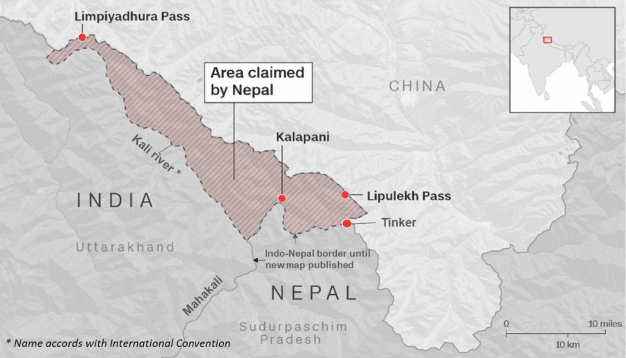
Naresh Koirala
Nepal’s publication of a new map showing the Limpiyadhura-Kalapani-Lipulekh area within its territorial boundary has raised passions here and across the border in India. The area in question, a 370-square-kilometre strip located at the north-western corner of the country, has been under Indian administration for a long time. But Nepal argues that, under the terms of the 1815 Sugauli Treaty, it is her land and should be returned. It looks like the newly unveiled map will bring India to the negotiating table. That is a good thing. History will tell whether the publication of the map was an effective strategy towards resolution of the dispute or a gamble with the potential for a long-term conflict with India.
The territorial boundary of modern Nepal was defined by the Sugauli Treaty signed with the British East India Company in 1815. It said that the course of the Kali River, called the Mahakali downstream, marked Nepal’s western boundary which is the subject of the current row. But there was no map attached to it; and if there was one, it has not been found. The Mahakali has two tributaries—one starting at Lipukekh and the other at Limpiyadhura. The treaty did not specify which of these two tributaries would be considered the Kali for the purpose of delineating the boundary. India says the Kali starts at Lipulekh, and Nepal says Limpiyadhura is the river's source.
A long time ago
India (pre- and post-independence) has held the disputed area for nearly 200 years since the Sugauli Treaty was signed. Nepal’s presence in the area has been sporadic and minimal, if any. India’s active police post at Lipukekh pass, which was established during the British days, continues to date. There is also an Indian military establishment in Kalapani.
In the early 1960s, king Mahendra gave consent to Indian Prime Minister Jawaharlal Nehru to continue the use of the Lipulekh-Kalapani area, according to the then Home Minister Biswabandhu Thapa. In 1961, Mahendra signed a boundary treaty with China, which says, ‘The boundary line starts from the point where the watershed between the Kali River and the Tinkar River meet the watershed between the tributaries of the Mapchu (Karnali) River on the one hand and the Tinkar River on the other hand’. This treaty makes Tinkar, about 10 kilometres south of Lipulekh—the tri-junction where the China-India-Nepal borders meet—and supports India’s current position.
In 1991, Nepal formally raised the border issue with India, and a technical committee was formed to resolve it. The panel identified several areas with contested claims and resolved 90 percent of them. But, according to Nepali sources, India repeatedly baulked at Nepal’s request for talks on Limpiyadhura-Kalapani-Lipulekh. The committee has not been active for the last few years. Since the Sugauli Treaty states that the area east of the Kali is Nepal, fixing the source of the river should resolve the dispute. Under the international convention, the tributary with the largest water volume or with the longest course carries the name of the main river. This would make Limpiyadhura the source of the Kali, but no border issue has been resolved on technical arguments alone. Realpolitik kicks in when solutions based on technicalities do not address the disputants' undeclared agenda.
And there is one more complication. The new map makes the tri-junction at Tinkar invalid. Settling the location of the new tri-junction will require the agreement of all three parties—Nepal, India and China. The long Indian presence in the area, the national security importance India attaches to the area, and the neglect by Nepali rulers for nearly 200 years to claim what rightfully belonged to Nepal has added to the complexity of the problem.
Given the lack of Nepal's presence on the disputed land for over 200 years, and the relative strength of India's economic and military might and international stature, it is doubtful much can be achieved by a confrontational approach or by internationalising the dispute, as some hotheads in Kathmandu are suggesting. Despite accusations by Indian opinion-makers' that Nepal is playing the China hand, China may not support Nepal's position. What China will do in the current dispute will depend on how it fits with Xi Jinping’s global agenda of 'rejuvenation of China’s glory'—China’s ambition to dominate the world. The Chinese Foreign Ministry spokesperson has already given an indication of their position: bilateral matter between Nepal and India.
Those who advocate internationalisation should ask what our fall back position is if India refuses to accept the World Court's ruling. The only option Nepal has is to try and resolve the issue through quiet diplomacy, through dialogue and forming Indian public opinion in our favour. This requires leadership with a very high moral standing; sensitivity, international respect, statesmanship, and an ability to communicate complex issues openly, politely, respectfully, and with firmness.
Shameful rabble-rousing
Prime Minister Oli’s speech in Parliament was contrary to everything called diplomacy, respect, politeness and statesmanship. It was full of bravado and contained little substance. By mocking India's national emblem and declaring that 'the Chinese virus was better than the Indian virus', Oli was insulting 1.4 billion Indians. This is not how we can build Indian public opinion in our favour. What he did was shameful rabble-rousing, impolite and unbecoming of a prime minister, any prime minister.
Our opposition in Parliament and civil society is faced with a difficult problem—simultaneously steering the government away from any major confrontation and towards a diplomatic solution on the border issue, and fighting the government’s incompetence and complicity in pervasive political corruption that has hollowed out the country. A difficult position, but Nepal has been through a lot. It will find a way out of this one too.


 16.12°C Kathmandu

