World
High probability of Uttarakhand-scale flood in Bhutan
The government has identified 17 potentially dangerous lakes in the country.
Asia News Network
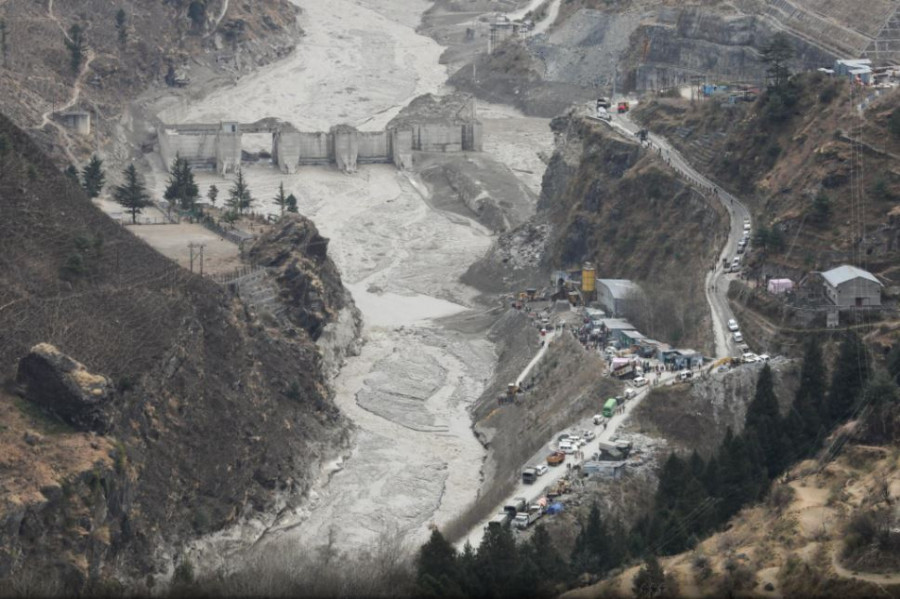
The devastation caused by the Uttarakhand floods earlier this month has once again brought into sharp focus the vulnerability of the fragile mountain ecosystem in the Himalayas. The probability of such climate-induced events, according to experts, is high in Bhutan.
With over 70 percent of the settlements in the valleys and major hydropower projects development along basins, a glaciologist with the National Hydrology and Meteorology Centre (NCHM), Toeb Karma, said that a flood of Uttarakhand-scale was likely to occur in Bhutan.
Although media reports attributed the cause of the Uttarakhand flood, which killed hundreds of people and damaged two hydropower projects, to ice breakage, avalanche, and collapse of a rock’s edge, Toeb Karma said that it could have been caused by rupturing of a lake hidden beneath or within a glacier called in-glacial lakes.
Although the lakes are not visible on the surface, occurrence of in-glacial lakes are common in the Himalayas. Bhutan does not have official records of the in-glacial lakes, but Toeb Karma said that it was prominent in the country. “There is a 13km in-glacial lake at Tshojong in Lunana.”
Rupturing of in-glacial lakes can be triggered by earthquakes, which might cause rockslides and landslides in steep terrain.
Records with NCHM show that the incidence of small-scale Glacial Lake Outburst Floods (GLOFs) has increased since the 1994 flood. “Uttarakhand incidence is a good reminder to Bhutan,” said the director of NCHM, Karma Dupchu.
He said that the Mangdechu project was at a higher risk. Mangdechu has five potentially dangerous glacial lakes upstream. “Mangdechu is a flashy river and the gradient is high.”
In flashy rivers, floods occur and recede suddenly in a short period of time.
NCHM estimates show that, from the monitoring room in Jongthang to Mangdechu dam site, the flood will only take about 50 minutes, and 88 minutes from Jongthang to the power plant.
According to reports, if the moraine dam breaches at Thorthormi lake, there will be 53 million cubic metres of water rushing down.
What can be done?
The government has identified 17 potentially dangerous lakes in the country. Water levels of Thorthormi and Rapstreng lakes have been reduced to safe levels. Hazard zonation maps and early warning systems (EWS) have been installed along Mangdechu, Chamkharchu, and Punatsangchu.
This, however, is not enough, according to Karma Dupchu.
He said that there was a need to upgrade EWS to a flood forecasting system, which needs more funds and government support. “EWS is the future. The casualties in Uttarakhand dam site could have been minimised if they had EWS.”
Most of the victims were power projects’ workers.
Although EWS had a life span of only five years, Karma Dupchu said that the EWS along Punatsanghu was used for over 10 years. They were maintained with the help of the United Nations Development Programme.
He said that the centre and Druk Green Power corporation should enhance partnerships to install and sustain the EWS infrastructure instead of depending on donors. Punatsangchu and Mangdechu projects co-financed the initial installation but not maintenance.
Installation of EWS along Wangchu is underway with support from the Japan International Cooperation Agency. A recent assessment has shown expansion of glacial lakes in the Pachu basin.
He said that to create a vibrant, research- and science-driven centre, there should be a separate office instead of being embedded within the ministry compound. “The science-based organisations should be well-equipped. We don’t even have enough space in the current office.”
He said that, during the lockdowns, it was difficult to maintain data and monitoring activities. Duplication of weather and climate-related projections by individuals, agencies, and institutions impeded the centre’s role in disseminating correct projections.
The centre also faces challenges due to lack of technology and equipment, inaccessibility to glacial lakes, and lesser window of opportunity to carry out surveys and monitoring works.
Bhutan has 700 glaciers in Bhutan that are losing their mass or retreating at an alarming rate. Experts warn that glaciers could disappear in the next 50 years if the trend continues.
The region has about 15,000 glaciers, which are retreating at a rate of 100 to 200 feet per decade. In Nepal, Bhutan, India and Pakistan, a large number of glacial lakes have been deemed imminently dangerous by the International Centre for Integrated Mountain Development.
This news article was obtained from Kuenselonline which is a part of Asia News Network.


 9.12°C Kathmandu


