 20.12°C Kathmandu
Thu, Apr 2, 2026
Opinion
Re-measuring Mount Everest
Survey of India is re-measuring the height of Mount Everest according to an announcement in Hyderabad during the celebration of the 250th anniversary of the institution.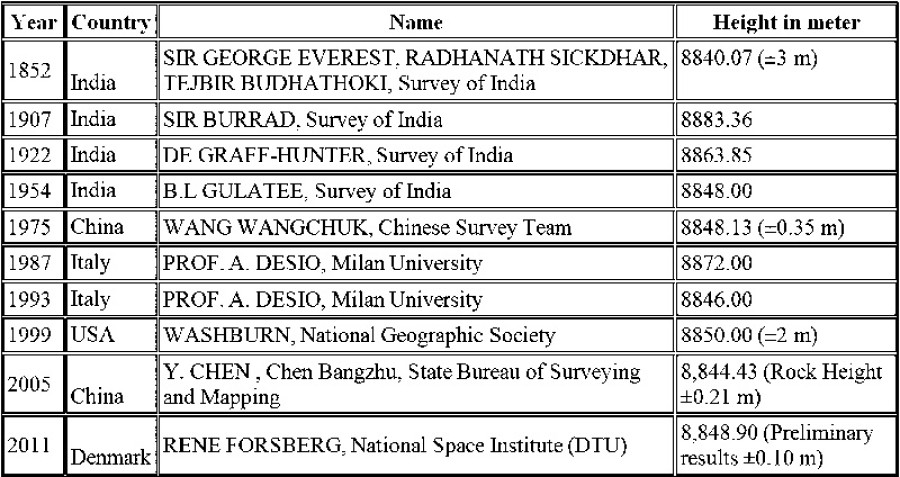
bookmark
Published at : February 21, 2017
Updated at : February 21, 2017 08:30
Survey of India is re-measuring the height of Mount Everest according to an announcement in Hyderabad during the celebration of the 250th anniversary of the institution. This is the fifth time that the height of Everest will be measured by India since 1852. All the necessary approvals have been obtained from the Ministry of External Affairs of India for the expedition. The matter of re-measurement of Everest was discussed on the sidelines of a meeting of the Geospatial World Forum. However, it was not discussed with the Director General of the Survey Department of Nepal, as he did not attend the conference.
Survey of India is planning to send a 30-member expedition team within two months. The endeavour would take about a month for observation and another 15 days for computation and declaration of data.
History of measurement
When measuring different peaks of the Himalayas in 1852, Sir George Everest, Survey Expert Radhanath Sickdhar, and Nepali Corporal Tejbir Budhathoki found Mount Everest to have the highest peak. It was marked as ‘Peak-XV’. Later it was named by the Royal Geographical Society of London as Mount Everest to honour George Everest, the then Surveyor General of India.
In Nepal, the peak was named Sagarmatha in 1938 after rigorous research by eminent historian Baburam Acharya. ‘Sagar’ denotes the heaven or sky in Sanskrit. ‘Matha’ signifies head or crest. In other words, Sagarmatha means ‘the head reaching up to the sky’. In China, it is called Quomolongma, and in the Tibetan language it is revered as a deity with the name Chopulongma.
Everest has been measured by a number of countries. If we look at the history of measurement, there are variations in different periods. The different measurements made by various institutions are shown in the table above.
Reasons for re-measuring
The earthquake in May 2015 changed the landscape of the region. The main reason for re-measurement is to verify claims expressed by some scientists that Everest shrunk (or grew) after the earthquake. Another reason is to help studies that are looking at the tectonic plate movements in the region. Soon after the earthquake, data from Europe’s Sentinel-1A satellite indicated that the quake may have decreased the height of several mountains, including that of Mount Everest.
John Elliott, a geophysicist at the University of Leeds in England, who has used satellite data to try to measure changes in the mountains, told Tia Ghose at Live Science: “I can’t say one way or the other whether Everest was affected. Because Everest is far away from the epicentre, we cannot conclusively say it went down; it is within the error of our measurement.”
The researchers India is sending this spring will measure the mountain using two methods. One is a survey instrument using the satellite system GPS. The second is the triangulation (ground survey) method, a traditional way to calculate the height from ground for better confirmation.
Nepal is the treasurer of Everest. It is our property and our heritage. We have to determine the height of our property ourselves with modern technology in a way that satisfies the researchers of the world. This is our responsibility.
Some people may ask if Nepal is capable of measuring the height of Everest. The answer is yes. A team of experts should be formed consisting of members from the departments of land survey, mines and geology and hydrology meteorology as well as experts from Nepal Academy of Science and Technology, the International Centre for Integrated Mountain Development (ICIMOD), and the computer association.
We have survey and Geographic Information System (GIS) experts and technicians who can handle a GPS system. They were educated abroad and have worked with GPS technology in other countries as well. They can compute and calculate the scientific height of Everest. The problem is that there is a lack of technical equipment, necessary funding, and a difficult working environment. It is estimated that the scientific expedition would cost approximately US$ 700,000.
The Survey Department had estimated the cost of measurement and submitted its findings. But funding has not been allotted because the expenses were considered ‘unproductive’ compared to the present need of rural development of remote areas.
Hasty observation and calculation
Some researchers believe that one and a half months to re-measure the height of Everest is not sufficient, because it is not enough to measure and simply calculate the figure; one has to determine the earth’s geoid using gravity measurements. An aeroplane has to fly back and forth over the mountain in a series of parallel lines to measure how much gravity affects its peak. This measurement should be done together with GPS observations from satellites. Besides this, vertical of deflection, tectonic motion, and atmospheric corrections should be applied. More time is needed to compare the GPS WGS-84 figure to the traditional triangulation data. So the time span that the Survey of India has allotted might have to be re-evaluated and extended.
When the National Geographic of America measured Everest in 1998, it took nearly two years until the final data was published. Researchers suspect that hastily computed measurement data may not be exact and accurate. If the final data computed is wrong and if it shows the height of Everest is now lower than that of the Mount K-2 (Mt Godwin Austin), what will Nepal’s position be? The outcome is of great concern to Nepal.
With a view to re-measure the height of Everest, it would be practical to collaborate with an equal number of experts of various disciplines from India, Nepal, and China. Nepal has to co-ordinate with India and China because Mount Everest is located on the Nepal-China border, and India was the first country to name the Peak-XV (Everest) as the highest peak in the world.
Nepal has to request India not to haste and measure the height alone. If it is measured through collaboration, the scientific community will be more likely to accept the measurement.
Shrestha is a border researcher and former director general of the Survey Department


Editor's Picks

Nepal risks losing up to 132,000 jobs, $1 billion after LDC exit

Raped and left to die, teenager’s family wants answers

Bengal tigers move to mid-hills. Sighted in Palpa, Arghakhanchi

Escaping poverty at home, Nepali women fall into the Gulf trap
Once the heartbeat of Nepali democracy, now a ghostly shell
E-PAPER | April 02, 2026
×