Opinion
Kathmandu rocks
Geologically, the valley, composed of fragile thick sediments, is analogous to a bowl of jelly
Deepak Chamlagain
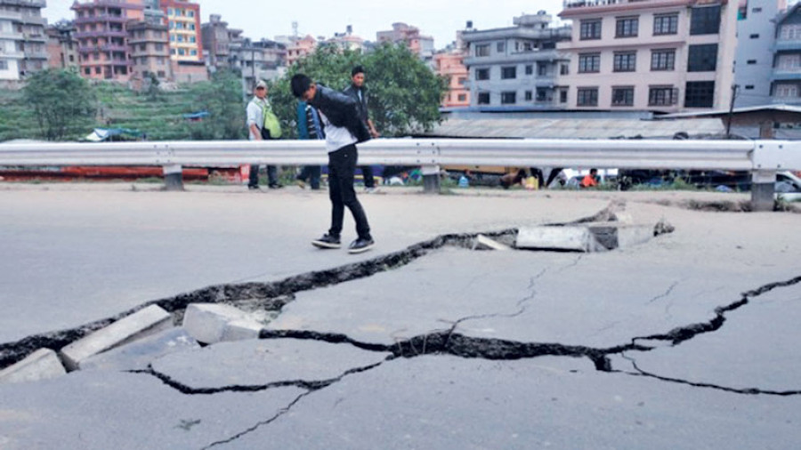
It has been one year since the devastating 7.8 magnitude Gorkha Earthquake which killed 8,977 people in central Nepal and caused economic losses totalling $7 billion. The tremor was unique in terms of seismo-tectonics that puzzled many researchers working in the region. It occurred in the easternmost part of the Himalayan Seismic Gap, a potential region for big overdue events. The intensity of the shaking was enigmatic in that soft soil deposits were less excited than the bedrock. The resulting pattern of damage and loss defied predictions, particularly in the Kathmandu Valley.
The Kathmandu Valley is bowl shaped and surrounded by hills of midland physiography. It is situated on the bedrock of the surrounding lesser Himalaya, and consists of soft sediments, mainly of clay, silt, sand and thin gravel bed. The valley is also characterised by remnant bedrock hillocks randomly distributed in the Pashupati and Swayambhu areas. Geologically, the entire valley is analogous to a bowl of jelly as it is composed of fragile thick sediments that are very sensitive to seismic excitation. The southern part of the valley is dominated by black clay that behaves like a jelly-like material and it can amplify the energy of seismic excitation several-fold. Another dominant soil strata are loose sands susceptible to liquefaction during major seismic events. These sand layers liquefied during the 1934 Bihar-Nepal and 2015 Gorkha earthquakes. Thus geologically, the soil strata are susceptible to liquefaction as well as seismic amplification fuelling earthquake risks.
Cyclic nature
Immediately after the Gorkha Earthquake, there were many blind views in the media from politicians to experts urging rigorous soil tests. But there was not a single call for a test that would help us to understand the seismic behaviour of the soil. We have been testing the soil to understand the static nature like bearing capacity and strength, and have been designing structures accordingly. However, soils behave in different ways during a seismic excitation. I have shipped four samples of soils from the Kathmandu Valley to Rome to understand the cyclic characteristics through a cyclic test for the first time in Nepal.
The soft black clay and silty clay have shown a unique characteristic with clear non-linear behaviour with a sharp decrease in strength with increasing seismic excitation. It has been also understood that the soil is very susceptible to liquefaction. Further, a one dimensional modelling of the soils of Kathmandu using the Gorkha earthquake has exhibited considerable reduction of ground acceleration in the valley soils. The non-linear nature of the soils has greatly reduced the acceleration of the Gorkha Earthquake on the soils of the Kathmandu Valley, inhibiting further amplification of the lethal waves.
Microtremor probing
A direct determination of dynamic soil properties at deep levels is often expensive. However, ambient vibration of the ground caused by manmade or atmospheric disturbances can be used to probe deep soil deposits to understand their dynamic nature. Considering the thickness of the soil strata in the Kathmandu Valley, we used a triangular array of the micro-tremor survey at 40 different places. The results are interesting in terms of shear wave velocity and stiffness of the soils, which affects the modification of seismic waves. In general, the upper 30 meters of the soil is characterised by a low shear wave velocity indicating susceptibility to amplification. However, deep soils are stiff enough for dampening seismic excitation. Thus, the fragile nature of the soils in the upper part of the valley can play a vital role in amplifying seismic risk during a moderate-sized quake.
The strong ground motion of the Gorkha Earthquake has shown less acceleration on rocks than the soils of the valley. The soil is characterised by non-linear behaviour with considerable damping capacity. Because of a strong ground motion during the Gorkha Earthquake, the soils of the valley behaved in a non-linear manner reducing ground acceleration. This led to less but disproportionate damage compared to the destruction caused by the 1934 Great Earthquake. Further, the soil greatly modified the earthquake frequency content of the waves, increasing the shaking at higher levels and causing greater damage to taller buildings than two-three storied residential houses.
Research for reconstruction
The government of Nepal has formed a powerful National Reconstruction Authority (NRA) to expedite the reconstruction process aiming to create effective coordination among the stakeholders. As per the programme, the NRA has started distributing Rs50,000 per household as the first instalment of a grant to build earthquake-resistant housing. There has been much debate among experts regarding the Build Back Better programme, but the government hasn’t made a move to do a disaster risk assessment of the resettlement areas. This has led to confusion among earthquake survivors about where to rebuild their dream quake-resistant houses. We have forgotten the devastation left behind by the earthquake, and have done no research or made timely plans to identify safe locations for people to rebuild their homes. The bitter truth is that we have no culture of conducting collaborative work with academia in terms of research on Disaster Risk Reduction and Management. The government should immediately start a geological risk assessment of the affected areas before the beneficiaries knowingly or unknowingly misuse the money given to them to rebuild their homes.
The level of our scientific understanding about the characterisation of our settlement is very limited, and we have done nothing to enhance our capacity to introduce modern techniques. This has a serious impact on our ongoing risk reduction programmes. The Kathmandu Valley is just an example, many other urban areas have not been studied seismically. Still, we can do a lot before starting reconstruction. At least urban and semi-urban areas can be investigated for seismic microzonation by understanding the cumulative effects of local geology, topography, seismic wave propagation and built environment. The key lesson of the Gorkha Earthquake is to integrate scientific research into the Disaster Risk Reduction and Management plan.
Chamlagain is an assistant professor at Tribhuvan University


 15.12°C Kathmandu


