Columns
Nepal’s cascading hazards
Scientific research can provide new insights into designing effective risk management strategies.
Rocky Talchabhadel & Sanjib Sharma
The Nepal Himalayas are prone to deleterious disasters from natural hazards, such as floods, landslides, debris flows, avalanches, glacial lake outbursts, river blockages, and other weather-related events and their combinations. The hazardous events and their consequences are prevalent in the Himalayas because of steep elevation differences, fragile geology, and seasonal variation in extreme rainfall. Every year, during the summer monsoon season (June to September), devastating floods and landslides result in over 250 fatalities in Nepal. In the last decade (2012-2021), 3.4 million people were displaced due to disasters or to avoid natural hazards. A single monsoon flood in August 2017 caused approximately 400 thousand displacements. Poorly planned human activities (such as settlement intensification and hill road construction), coupled with ongoing climate change and climate variability, have exacerbated the triggering factors of multiple hazards.
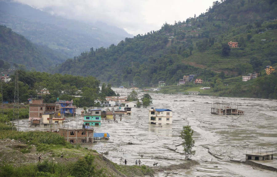
Recent cascading and compound hazards, for instance, the 2021 Melamchi flood, need a better understanding of the complex links between human activity, environment, and infrastructure. These hazards have caused immense losses. The 2012 Seti Kharapani flood killed over 70 people and impacted many. Similarly, the 2014 Jure landslide engulfed over 150 people, submerged houses and infrastructures, caused over 40,000 displacements, and disrupted the country’s economy for over a month. They had far-reaching repercussions resulting in numerous casualties as well as affecting local, regional, and national economies.
We can take proactive measures to prepare ourselves and mitigate the potential damage of natural hazards. However, the formation of cascading hazards remains poorly understood due to the limited predictability of extreme weather conditions, the high computational cost to run sophisticated models, and a lack of datasets to characterise the Himalayan landscape. To address this pressing issue, we need a dynamic and generalisable framework that can help to identify and monitor the connection between the various elements and their associated risks in the region.
New scientific insights
Talchabhadel et al. (2023) conducted a diagnostic analysis of the 2021 Melamchi flood. The study integrated remote sensing data, hydrologic and hydrodynamic modelling, and machine learning techniques to understand the individual and interacting dynamics of several physical processes and their cascading and compound effects. Given the high risk of landslides in mountain areas, particularly following the 2015 Gorkha Earthquake, it is essential to assess the risk susceptibility of settlements and infrastructure on a timely basis to prepare for potential future landslides.
In the case of the 2021 Melamchi flood, the landslide dam’s outburst, combined with rainfall, resulted in a sudden breach of accumulated water that caused sediment-laden flooding over a broad area and severe damage down to the Melamchi Bazar. This emphasises the need and importance of evaluating risk by considering a range of non-extreme circumstances in addition to extreme ones. The Melamchi flood should be viewed as a warning that other areas may be at risk of similar cascading and compounded hazards.
It is essential to assess the vulnerability of infrastructure to various hazards (such as mapping landslide susceptibility, delineating flood plains, mapping fire risk in forests, and others). The threshold for rainfall that leads to different hazards triggering landslides must be regularly updated using data collected at a high frequency. Interactions between hazards must be studied closely, as a combination of non-catastrophic events can create unforeseen compounding hazards. Also, a small hazard may start in one particular location but can escalate in magnitude and extend to impact a broader area and for a longer period. Additionally, sediment-laden floods behave differently than clear-water floods. Large seismic activities can also cause massive landslides, block rivers and create temporary reservoirs behind unsorted and unstable deposits.
There is an insufficient number of hydro-meteorological stations to effectively evaluate the situation. Properly utilising earth observations and satellite-based estimates is essential when gauge data is unavailable. However, these products should first be tested against gauge data to ensure accuracy. Gauging stations may fail to provide data during extreme weather conditions. The national weather radar network is not yet complete, with some areas of the country still not being monitored. There may be a dearth of skilled personnel to tackle the concern.
The National Disaster Risk Reduction and Management Authority (NDRRMA) is making strides to digitise disaster risk management by creating the Building Information Platform Against Disaster (BIPAD) portal. This platform combines data from various authorities, non-government organisations, educational institutions, and research firms. Stakeholders and users can access indicators of various disaster-related activities throughout the country.
Investing in science and technology
Currently, available scientific resources are inadequate to understand complex weather processes in the Himalayan region. More investment is needed in science and technology to enhance resilience to face extreme events. We must train and educate the new generation in emerging technologies like machine learning, high-performance computing, and new Earth system models. This also demands coordinated and collaborative research and exposure to the wider scientific community for accurately and effectively predicting cascading hazards and formulating strategies to mitigate associated risks. Undergraduates, graduates, and doctoral students should be encouraged to research and participate in projects and capstone initiatives that address real-world problems.
Making government data and research open to the scientific community can promote transparency and trust in the scientific process. Satellite-derived estimates, remotely-sensed data, earth observations, and re-analysis data can be beneficial to acquire information in areas where data is sparse. Nevertheless, creating a comprehensive network of gauging stations should be paramount to making informed decisions. Importantly, measuring is an essential part of assessing any situation, and understanding the full scope of a situation is difficult without ground-based observations.
A data-driven model and machine learning approaches that integrate hydroclimatic models, remotely-sensed data, and non-traditional data sources such as Citizen Science and expert knowledge needs to be developed. Such a modelling framework would act as an operational decision support tool, enabling stakeholders to conduct “what-if” analyses and design mitigation strategies. To make the tool more accessible, it should be implemented as either a cyberinfrastructure or a mobile application. Decision support tools should not only provide data about past incidents but should also provide information to assist in making informed spatial decision-making about financing in climate-resilient critical infrastructure.
To complement data-driven models, anticipatory actions must be taken based on our results and knowledge. This can be practised through various means, such as early warning systems, improving the adaptive capacity of the communities, and considering risk in spatial planning and infrastructure designs. These can be effectively practised with coordinated approaches with governments, stakeholders, and communities, such as community-based disaster risk reduction, participatory approaches, ecosystem-based approaches, and prepared and response training. Traditional and indigenous wisdom can help better implement and align these measures with the local context.
Local authorities must adopt and timely update a comprehensive plan that includes an early warning system, prevention measures, mitigation strategies, and response protocols. This plan must also entail emergency procedures to coordinate evacuations and to provide prompt relief and assistance to those affected by the hazards. In addition, public awareness, education programmes, science, and effective communication must be implemented to ensure that people know the potential risks to their locality and are equipped with the knowledge to respond effectively.


 9.12°C Kathmandu


