Columns
Multisectoral multiscale disasters
Investment in science is crucial for improving the prediction of cascading hazards and risks.
Sanjib Sharma & Rocky Talchabhadel
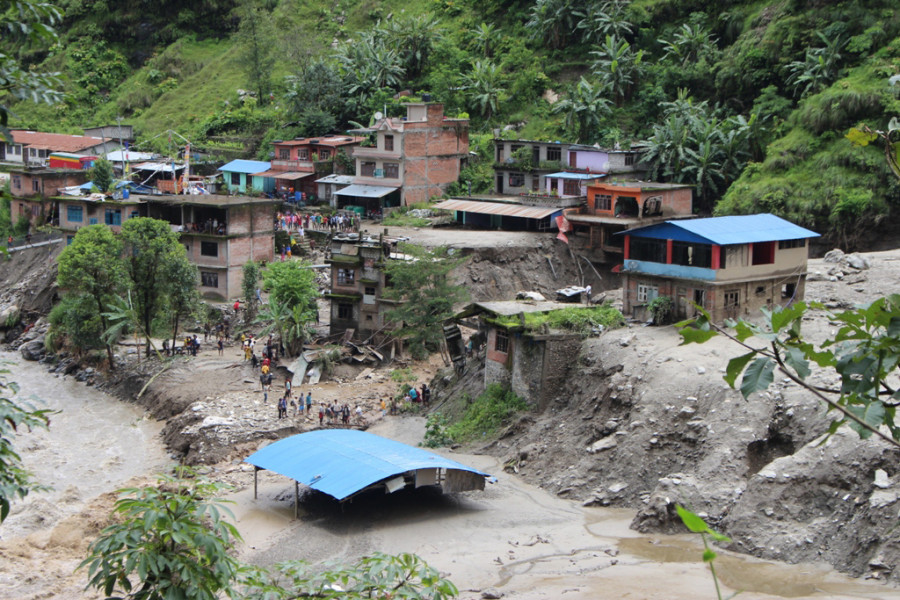
Losses and damages from natural hazards are escalating. Over 70 people died in the 2012 Seti flash flood, 150 in the 2014 Jure landslide, and 20 in the 2021 Melamchi flood. Tens of thousands of people are displaced. Weather-related losses in Nepal are among the highest in the world. The impacts are multisectoral, threatening human settlement, critical infrastructures, economy and ecosystem.
Extreme weather, climate, and water conditions are rising in Nepal, according to a recent study published in the scientific journal Natural Hazards. And extreme events are likely to become more frequent and intense as climate changes. That means more record-breaking rainfall, floods, heat waves, drought and wildfires are expected in the next decades.
Cascading hazards
Cascading hazards result from a series of hazardous events and their interactions. One hazard often triggers another hazard (Event A is followed by Event B, which is followed by Event C and so on), and the compounding impacts lead to massive disasters. For example, rainfall after wildfires can trigger massive landslides and floods. Cascading events may begin in a specific location; but can intensify, propagate and become widespread to impact more extensive areas.
The upper Himalayan regions are more prone to snow and glacier avalanches. Global warming can cause the early onset of snowmelt, amplify the glacier melt rate, and contribute to glacier retreat. The number and size of glacial lakes are proliferating. Many of these lakes have unstable moraines (dams). Impacts from rock/ice avalanches or landslides can destabilise the dam, increasing the chances of glacial lake outburst floods with disastrous downstream consequences.
The Mid-Himalaya are affected mainly by landslides. Landslides often block the river and create landslide-dam lakes. In August 2014, prolonged rainfall induced a catastrophic landslide in Jure, Sindhupalchok. Debris from the landslide formed an earthen dam that blocked the Sunkoshi River. Landslide-dam lake destroyed sections of the Araniko highway, disrupting cross-border trade exchange. The cascading event interrupted the power transmission from five hydropower projects and caused a deficit of 66.5 megawatts of electricity in the national grid.
The 2021 Melamchi disaster resulted from multiple hazardous events that cascaded from high elevations to river valleys. Heavy rains in the upstream region triggered a massive erosion of glacial deposits, overtopping of a glacial lake, and temporary damming of a river. The dam breach resulted in a large flow of debris and a sediment-laden flood. Continuous toe-cutting and river aggradation from landslides made the river system vulnerable even to moderate rainfall.
Seemingly normal weather conditions can trigger a chain of hazardous events with disastrous consequences. Days of warmer temperatures in the higher altitudes increase the chances of glacial lake outburst floods. A series of average rainfall events in regions with altered land use and other human activities increase the probability of landslide dam outburst floods. The interaction between glacial lake outburst floods and landslide dam outburst floods amplifies flood risks in the downstream settlements.
The southern plains are more susceptible to floods and sediment deposits. Sediments eroded from the Himalaya are transported and deposited on the southern plains. Such depositions can change the river landscape and inundate floodplains. The Koshi flood of August 2008 is a typical example where embankment failure altered the river course. The flood deposited large amounts of sediment on agricultural fields, drastically reduced crop yields and affected millions.
Land use and land cover changes can increase the risk of wildfire, landslide and flood. Wildfires can make the landscape susceptible to landslides even under normal rainfall conditions. Deforestation and unplanned earthen road constructions exacerbate the risk of landslides and flooding, particularly during the monsoon season.
Human activities most often cause wildfires. Wildfires and severe heat waves in the southern plains have been happening more frequently in recent decades. Dry wind exacerbates wildfires, magnifies air pollution and threatens public health. Rainfall over the burned areas can cause flash floods, increase soil erosion, and drastically deteriorate water quality.
Cascading hazards lead to cascading failures across critical systems. For example, urban areas like Kathmandu and Bhaktapur are at high risk of heavy floods due to unmanaged development patterns and river encroachment. Floods overwhelm the drainage system, lower water quality, inundate the streets and destroy the power grid. Critical infrastructure such as fire departments, schools and hospitals lose access to power supply, transportation, water and communication.
Managing hazards
Investment in science is crucial for improving the prediction of cascading hazards and risks. More research is needed to understand what drives natural hazards, their interactions and failure modes, and how human and physical systems respond to risk and failures.
Better data and computer models are needed for effective hazard prediction. For instance, urban flood modelling requires a detailed representation of local rainfall, land surface characteristics, surface and subsurface flows, drainage networks, buildings, roads and water infrastructures (culverts and bridges). Predicting how risk evolves with time requires a sound understanding of future climatic conditions, development patterns, vegetation dynamics, demographic changes and adaptation strategies.
Opportunities exist in improving the predictions of cascading hazards. Recent advances in modelling capabilities, emerging computational innovations (high-performance computing, artificial intelligence and machine learning), and the availability of high-resolution remote sensing and satellite information can help in improving our understanding, modelling and predictions of cascading hazards.
Reliable early warning systems are critical for disaster preparedness and management. However, current early warning systems focus on a single isolated event, mostly on heavy rainfall and floods. We need to develop, expand and automatise early warning systems to communicate the risk associated with potential hazards, their interactions and cascading phenomena.
Infrastructure design specifications must change with the changing climate. Engineers often rely on historical climate records to design water infrastructure, transportation systems and commercial buildings. Scientists have produced many different projections of future climate. Engineers and decision-makers need to evaluate the performance of design strategies across the entire plausible range of future climates to identify robust design choices.
Adaptation and mitigation responses should be socially equitable, scientifically sound and economically efficient. Such an approach helps to enhance resilience in diverse, vulnerable and underserved communities. Resilient risk management strategies could be expensive and require strategic investment policies. Engineers, climate scientists, risk analysts and policymakers must work closely to manage risk and optimise cost.


 9.12°C Kathmandu


