Editorial
Dialogue of the deaf
Both Nepal and India have made unilateral moves to stake their claim at the source of the Mahakali. Now what?
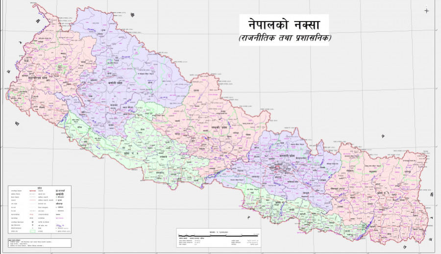
In a strong statement, staking its long-held claims on disputed territory, Nepal on May 20 released a political map that for the first time included Kalapani, Lipulekh and Limpiyadhura within its territory. While the Oli government has been lambasted for attempting to use the issue of the disputed claims to distract the public from its failures in managing the SARS-CoV-2 crisis at home, to some extent it had no other option. In a short span of time, India has moved unilaterally to secure for itself all the territories on Nepal’s northwest corner.
First, it followed up on previous agreements with China to open up border passes by signing an agreement in 2015 to develop the road to Kailash-Mansarovar, which passes through Lipulekh, that Nepal has claimed as its own for long. In doing so, both China and India ignored Nepal. Then, last year, after revoking Article 370 in its Constitution, thereby scrapping the autonomous status of Jammu and Kashmir, Delhi released a new political map of India. While Lipulekh and Limpiyadhura have been featured in India’s maps for a long time, something Nepal’s leaders have tacitly acquiesced to (besides the routine call for dialogue) this new map placed Kalapani within Indian borders. That stirred public sentiment against India again in the latter half of 2019, reversing the years of healing it took for the public to somewhat forget the 2015 economic blockade.
Finally, the straw that broke the camel’s back: India decided to ignore Nepal’s recent calls for dialogue to sort out the border issues, and then decided to inaugurate a new road development through Lipulekh, in the midst of a pandemic. India’s moves in this whole debacle have been insincere. Even if it claims total sovereignty over the disputed area, it must as a good neighbour sit down and open a dialogue with Nepal on the matter. Yet, time and again throughout history, it has used Nepal’s disadvantage and the leaders’ partial silence to completely ignore the claims.
Now that Nepal has released its map, and the Indian government subsequently released a strongly worded statement, analysts say the two countries are in a ‘cartographic war’. With the addition of 335 square kilometres of land within Nepal, the total area of Nepal now is 147,516 square kilometres, up from 147,181 square kilometres. The government has said it has historical evidence and facts to prove that Kalapani, Lipulekh and Limpiyadhura are Nepali territories. A day ahead of the official release of the new map, Prime Minister KP Oli told Parliament that his government would soon reclaim the disputed territory.
Nepal has made the boldest move it could, given the circumstances. But a dispute of any kind—whether cartographic, diplomatic or economic—is not a good prospect for either country. It is not good for bilateral ties, for people to people relations or for regional stability. Nepal cannot survive without its largest trading partner, and India cannot thrive with a hostile neighbour. The onus is now on India to use this development to open an avenue for dialogue—something Nepal has wanted all along. Both countries should find an amicable solution, given the remarkable and historical ties they share.


 13.12°C Kathmandu


